Hey, there! Log in / Register

Maps in BPL's exhibit show locations of rebel alliance
By JohnAKeith on Fri, 08/21/2015 - 4:48pm
The Norman B. Leventhal Map Center at the Boston Public Library (BPL) is hosting an exhibition, "We Are One, Mapping America's road from revolution to independence" to commemorate the 250th anniversary of the colonial resistance to the British Stamp Act.
This week, four new maps from the King George III Topographical Collection and other collections at the British Library were added to the exhibition. These maps are "one-of-a-kind", watercolor paintings in a beautiful 18th-century style.
A Plan for Boston and its Environs (1775) shews "the true Situation of His Majesty's Troops, and also those of the Rebels; likewise all the Forts, Redouts and Entrenchments erected by both Armies". Apparently, it was no secret where the British were located, or the "American" rebels.
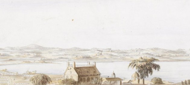
The artist of that map, British Lieutenant Richard Williams also drew a series of six watercolor landscapes providing a 360-degree panoramic view from Beacon Hill, of which four (I think) are on display at the BPL.
One depicts British encampments in the foreground with George Washington’s headquarters across the Charles River. Another features North Boston with the ruins of Charlestown, which burned during the Battle of Bunker Hill. A third includes John Hancock’s house, on Beacon Hill. (It was next to where the State House stands; torn down mid-19th century.)
The exhibit is at the BPL until November 29th.
Much of the BPL's and Map Center's permanent collection can be viewed online.
EDIT: I wrote this up before realizing that Steve Annear wrote an article for today's Boston Globe with more details & information. (Subscription required.)
Neighborhoods:
Topics:
Ad:
Support Universal Hub
Help keep Universal Hub going. If you like what we're up to and want to help out, please consider a (completely non-deductible) contribution.
Comments
Dantooine. They're on
Dantooine. They're on Dantooine.
Among the many amazing
Among the many amazing artifacts in the collection for "We Are One" is Washington's Boston medal. It was proposed by John Adams after the British evacuated Boston in 1776 and eventually presented to George Washington in 1790.
Poorly displayed
I understand that there are likely conservation issues that I don't fully understand, but the lighting there pretty much sucks. Looking at the maps is kind of like trying to read a book through an aquarium. I went out of my way to check these out this morning. Pretty disappointing.