Hey, there! Log in / Register

Plans filed for all affordable, 12-story residential building in Chinatown
By adamg on Tue, 12/05/2023 - 11:35am
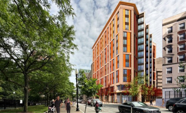
Rendering by Stantec.
Two non-profit groups have filed formal plans for a 12-story residential building with all the units rented or sold as affordable on what is now a parking lot at 290 Tremont St. in Chinatown.
Under the plans by the Asian Community Development Corp. and the Community Builders, 96 units would be rented as apartments, 36 sold as condos. Roughly 75% of the units will have two or three bedrooms.
Because of its location near two Orange Line stops, South Station and several bus routes, no parking is proposed for the building.
The site is owned by the BPDA, which would lease it for the new project.
The building will have 2,500 square feet of "community/commercial" space on the ground floor.
Neighborhoods:
Topics:
Free tagging:
Ad:
Support Universal Hub
Help keep Universal Hub going. If you like what we're up to and want to help out, please consider a (completely non-deductible) contribution.
Comments
Fantastic!
The only possible complaint is that in such a location, it should be twice as tall and have twice the units.
another possible complaint
Is that "Affordable" (with a capital "A") set aside units create a hole for families in the 100%-150% AMI income level who are too wealthy to buy an income restricted unit but also too poor to afford a market rate unit.
Agreed
1000% agree. And eliminating parking spots in a location like that is an added bonus.
That was the original plan
Five years ago, this was proposed for 30 stories. But between NIMBY influenced review and changing financing options, it was cut down significantly. Still better than nothing, but not as much housing as should be built at that location.
Now Get The Street Car Tunnel On The Left Open
The architects really went for broke making Eliot Norton Park look like it was a forest.
Wouldn't it be great if trolleys from City Point, Roxbury, and the South End got to use the tunnel that is under that grass on the left again?
No.
Unless you are being facetious.
Go Back To Ohio
If you want a little tidy midwestern village.
More trolleys (put into existing infrastructure) is what is needed over buses and old pathetic men complaining about the possibility of extra MBTA service that might interrupt their watching The Talk.
So you’re being a nostalgic fantasist.
Thanks for the clarification.
It would cost real money
But it's not a terrible idea.
The issue is that the T runs its trolleys as if they were running a tourist streetcar with 10 mph limits when interacting with traffic, which makes for less predictability as trains slow for green lights and traffic expects them to stop but they don't. With improved operating rules, which would be safer, the amount of street running to have a reasonable transit service via the old Pleasant Portal might make sense.
Tremont is 68' wide there including the sidewalk along the park, and portals are about 30 feet wide. Retaining a 10 foot sidewalk would leave 28 feet, enough for two lanes and a bike lane there. One-way pair the service on Oak/Washington and Shawmut/Marginal over to get to Washington with platforms along the sidewalks. The north end of Washington is narrow (48') but probably wide enough to keep a light rail service out of mixed traffic (maybe running it along one side of the street, with one lane of traffic and parking on the other), widens out until Nubian, before another bottleneck there. Make Warren a transitway?
It would then make sense to push this south to Mattapan since light rail on Blue Hill would be relatively easy. The first mile to Quincy Street is plenty wide. The next half to Grove Hall would also require some sort of transitway; the street is only 40' wide (since light rail vehicles have much tighter tolerances than buses, a light rail transitway can actually be somewhat narrower than a busway). There's only one curb cut on the west side of the street, and it's to an ABCD parking lot that could be accessed from a side street). The street would lose much of its parking (but keeping 21 feet on one side of the street for a travel lane and parking would work).
Then it's a straight shot down BHA to Mattapan.
The T can lay track quickly when it wants to and basically all of this had streetcars at some point so the utilities probably aren't too bad. But it, and the city, and the neighborhood, would have to want to, and find the funding, and good luck getting those stars to align.
What about
What about turning the tunnel east to connect with the underground Silver line at South Station? BHA seems more suited for heavy rail than light rail.
All this talk gets me so excited about the potential of the MBTA, but then the realities of the neighborhoods, city, state, and the MBTA bring me back down to earth.
Go to Archboston.com
There are some deeply detailed discussions on that architecture/urbanism board regarding this very idea. Essentially, there would be a junction designed to allow Nubian cars to go either to the Seaport via South Station, or to Park St and beyond. Likewise, cars from the north would have the option of going toward Copley, Nubian, or the Seaport. It's all very doable, but as Ari notes, the key requirements of funding, political will, and neighborhood buy in are not currently there.
Anything on the surface
Should be light rail.
Heavy rail is Red-Orange-Blue. The cars are wider and can't take sharp curves, the trains are longer, and they operate off of third rail power, which would be next to impossible in a shared right-of-way (there are third rail power crossings in a few places, notably Long Island, Westchester and Chicago, but the T wouldn't want to do this and probably for very good reason). Plus, the tunnel which extends south of Boylston was built for streetcars, which would preclude Red Line-sized trains (Orange and Blue line trains are sized for streetcar tunnels since they originally were streetcars; in fact the Orange Line used this very tunnel from 1901 to 1909 when its own tunnel was complete). They also have higher floors, so level boarding from the street would be more difficult. Light rail is basically Beacon and Comm Ave, which would look quite nice along BHA (with, you know, some trees, although the same could be said for Comm Ave in Allston, too).
The tunnel from South Station to the Silver Line was a complete white elephant which was rightfully killed off. Buses in tunnels just don't work, they require much wider tolerances, operate at lower speeds, and given the amount of water present under Boston, the pavement doesn't last well, especially since buses have very heavy axle loads so they require a lot of concrete. But then at Boylston, because the existing Green Line tunnel is stacked over the old Green Line tunnel, the bus tunnel was going to have to go three levels down, and then make some kind of loop under the Common, with all sorts of environmental and historic issues there, to get to the second level. And no one could even explain why a slow bus ride underground to get from Nubian to the Airport was worth $1.5 billion. The bus lane on Essex Street and the transfer to the Silver Line there made just as much sense for less than a penny on the dollar. Even better would be to put the Silver Line on the surface in a bus lane on Summer which would be way faster than the underground loop-the-loop. The tunnel there was originally designed for light rail, which would be far better at handling the crowds on rainy days on the Silver Line (which is at capacity when it rains or is cold out because people will generally walk to South Station which is faster, but take the bus when the weather precludes this).
tl;dr light rail
Appreciate the info
I meant put heavy rail UNDER Blue Hill Avenue because of the ridership, but appreciate the information on the Silver Line and Boylston stations.
The section of the abandoned
The section of the abandoned tunnel under Tremont where the eastbound/westbound tracks
come together: https://en.wikipedia.org/wiki/Tremont_Street_subway#/media/File:Pleasant...
would need to be widened. It was able to accommodate 100 inch wide PCC cars passing each other at speed until the line closed in 1962, but the space between the tracks (the "devil strip") is too close for 104 inch wide Type 7/8/9/10s to pass each other without danger of sideswipe if one of them was rocking. (This was even the case before the tunnel closed in 1962, as the 104 inch wide Picture-Window PCC cars of 1951 build could not be used on the line except for one special move of one car running in one direction on a fan trip). This unpleasant truth has been mentioned by the MBTA in past discussions of reviving the tunnel, but is never acknowledged by advocates of reusing the tunnel.
Not at the expense of a well loved and fully used park …
… in Boston’s densest neighborhood which will become denser if the Tremont proposal is okayed.
If the old Pleasant St portal can be reopened and used without destroying the park and the size of the old tunnels work with modern equipment, then it might work. But there are many other options to be explored.
The city is studying decking
The city is studying decking over the Pike between Shawmut and Washington, a block away from Eliot Norton Park, and putting a new park there. I'm not saying the loss of an existing park would be a good thing, but it's not the end of the story for this neighborhood. Neither of these projects is likely to ever happen of course.
Thats a thought!
.
Wouldn't that release the C.H.U.D's?
BUT seriously... Is the round building at one corner of the park still a church? I went there once after St. Phillip's on Harrison Avenue burnt down on a field trip from the "temporary" sanctuary that replace it. I finally settled down at Immaculate Conception Church also on Harrison Avenue, As I recall the round church was truly multi-denominational.
BOT: That design looks ultra-cool. I wouldn't mind living there.
The church is long gone
It was a theater for a while, but now appears to house some sort of media and communications consultancy.
You knew this was coming
“ Because of its location near two Orange Line stops, South Station and several bus routes, no parking is proposed for the building.”
Developers have this sentence on their clipboards so all they have to do is cut and paste it on their application.
From the rendering, I can't tell if it's going to be...
...lovely or hideous, but at least it's not going to look like every other g**d*mmmed piece of cheap crap we're throwing up every 37 seconds in this (and every other) city.
Stantec is generally a cut
Stantec is generally a cut above.