Hey, there! Log in / Register

Where the trees are
By adamg on Wed, 02/28/2024 - 10:27am
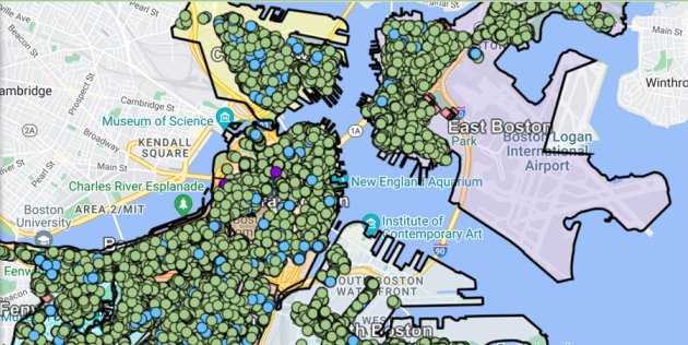
Fronm the Boston tree map.
All of Boston's street trees, mapped.
The data comes from the city's inventory of both street trees and trees in parks, which is available for download as spreadsheets.
More info on Boston's "urban forest" efforts.
Neighborhoods:
Free tagging:
Ad:
Support Universal Hub
Help keep Universal Hub going. If you like what we're up to and want to help out, please consider a (completely non-deductible) contribution.
Comments
But
Where are all the trees on the Commonwealth Avenue Mall from Dartmouth Street to Kenmore? I saw them yesterday, surely they can't all have wandered off.
also missing
The trees in the public garden
Is that a city of Boston park
Is that a city of Boston park or a special entity for the common?
May be a tract boundary issue
Census tract-based mapping can get weird like that - if nobody lives in a space, it isn't included in the tract. Meaning that the Common and Garden and the Comm Ave Mall are excluded at the margins of tracts.
ETA: this map doesn't include trees in parks - just the street trees. Comm Ave Mall, the Arburrito, Car Infested Expressplanade, and Common/Garden are thus not included.
But
The trees on the Mall appear on the map between Arlington and Dartmouth so explain me that.
Included in a tract/block group
I compared it with a standard tract map for Massachusetts. That upper part is included an areal unit. The Common, Garden, and most of the Comm Ave. mall are not - they have been excluded because nobody lives in them and they are sufficiently separated from the houses around them.
Read the article
"Street trees" - trees in sidewalk tree pits. Not parks, etc...
I did some tree stuff for
I did some tree stuff for this project. I identified, measured and logged trees in the area of the dead end of HP Ave. My old HP area is tree deficient.
What, there are no trees in the Arnold Arboretum?
In fact, there don't seem to be very many trees in the city at all.
Street Trees
Arb trees aren't street trees.
See also - comment about areal boundaries.
I think we need to learn to read the map correctly
Don't worry, the Arnold Arboretum. Franklin Park, Forest Hills Cemetery, Jamaica Pond all are densely tree laden. The map draws from census data and unless the animals in Franklin Park Zoo or the ducks in the pond get counted during 10 year census then this shall continue to be the way.
Different colored pins...
... but I see no guide to what the colors mean.
:-(
kind-of
More of a map of tree pits. Zoomed into my block and many pits are, in reality, empty. (and they missed at least one tree pit) But a cool tool to identify the empty ones and give the city a hard time...