Hey, there! Log in / Register

As odds rise of a Sandy-like storm here, so do the chances the T could be pretty much wiped out, new study finds
By Oliver Blake on Sun, 04/30/2023 - 9:51am
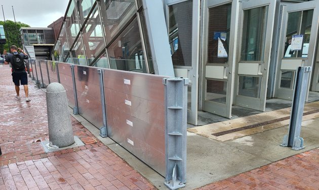
Is a temporary steel wall enough? The T now surrounds one Aquarium entrance with steel panels before potential flooding. Photo by Nicholas Bauer.
The T is already spending more money every year repairing storm damage and that's even before we get hit by something like Hurricane Sandy - or worse - in the coming decades according to a study published last week.
The report, by Michael Martello and Andrew Whittle in Communications Earth and Environment, paints a grim worst-case picture that would make the 1996 Muddy River flooding that shut Kenmore station for several weeks look minor: In the worst case, in a "100-year-storm," a rising Boston Harbor would pour into the T, starting at Aquarium, and flood all four subway lines and the Silver Line tunnel downtown with corrosive salt water, up to a depth of 15 feet, causing billions of dollars of damage in addition to the flooding along low-lying stretches of the T, such as almost all of the Blue Line in East Boston and Revere.
The authors caution, however, that the worst-case scenario assumes no new mitigation effects are in place before a Sandy-like storm hits.
In February, the BPDA agreed to spend $880,000 to study ways of fortifying Long Wharf, under which the Aquarium station largely sits, against rising sea levels, both to protect the historic wharf and to keep it from becoming a flood gateway to the rest of downtown. The city is also in various stages of planning for heading off future catastrophic inundations, through everything from turning parks into sort of giant sponges to sop up water to possibly building a flood barrier across Fort Point Channel. And the Army Corps of Engineers, which has proposed a $52 billion system to protect New York City, says it will begin looking at Boston as well.
Their report estimates that the MBTA's costs for dealing with just today's flooding issues has doubled since 2008, to $24.4 million a year and will likely more than double again by 2030. They detail would could happen in a "100-year storm," similar to what happened in New York when Sandy hit:
Here, we observe widespread flooding throughout Greater Boston, with inundation along the entirety of the Blue Line, significant portions of the Orange, Red, and Silver Lines, and at critical rail maintenance facilities along the Orange, Blue, and Red Lines. The results ... show widespread flooding along the at-grade portions of the system with significant volumes of inflow into underground portions of the system, primarily through tunnel portals, that generate inflows one order of magnitude greater than other ingress pathways at transit stations (e.g., station entrances, ventilation shafts, etc.). The analyses show widespread flooding throughout the underground portions of the system in Downtown Boston, due to the interconnected nature of the underground space that allows floodwaters to inundate adjacent lines in the system. ... Here, we expect flood depths exceeding 5 m [roughly 15 feet] along the majority of the Red, Orange, Blue, and Silver Line tunnels reaching to the crown of the running tunnels. At this level of saltwater inundation, we expect most linear assets (i.e., rail, signals, power, lighting) and stations to sustain damages equivalent to at least 75% of replacement cost.
Considering the projected extent and severity of saltwater inundation across the entirety of the system, we estimate $5.3B (2020 USD) in direct flood damages to the MBTA rail rapid transit system, with expected losses of ~$1.2B to the Red, Blue, and Orange Lines. ... We further observe that damage to connecting stations (i.e., stations where passengers can transfer) are expected to contribute $1.4B in flood losses, a greater proportion than any single line in isolation. We note the significant uncertainty in transit station replacement cost estimates largely informs uncertainty in station flood damage cost estimates, as well as uncertainty in overall flood damage estimates.
Free tagging:
Ad:
Support Universal Hub
Help keep Universal Hub going. If you like what we're up to and want to help out, please consider a (completely non-deductible) contribution.
Comments
Warning Shots All Around
While Superstorm Sandy was the wakeup call, it doesn't even take a hurricane to mess up the blue line at Aquarium - remember March 2018? A Noreaster on top of a high tide will just about do it now.
NYC has had a lot of problems even after Sandy - like Ida and other deluge storms.
How about a real solution?
If it's really going to get this bad, why aren't we talking about real, if expensive solutions, like a movable sea barrier between Deer Island and Long Island along with a permanent barrier between Moon Island and Long Island (much cheaper than a bridge) built with a road on top that would allow all the social services for the addicted and homeless on Long Island to reopen? Sure it would be unsightly and environmentally harmful, but Boston being destroyed by a flood would be unsightly and environmentally harmful as well.
Any sea barrier solution is
Any sea barrier solution is based on the idea that the sea won't rise that much for a long time. Just about everything I read (mainstream stuff) related to the fast warming of the poles suggests otherwise.
Problems with sea barriers
A sea barrier as you propose would result in additional flooding in areas outside the barrier on the north and south shore. Revere, Lynn, Winthrop, Nahant, Quincy, Weymouth, Hingham, Hull.
I doubt that people in those areas would appreciate being destroyed by floods either.
25 years ago
The mighty muddy waters rose and wiped out the Green Line from Kenmore to Boylston.
Hurricane Sandy
Only NYC can act like Yankee fans and putting the spotlight on them having a “Superstorm” and not just like a hurricane like everyone else. Vain pricks.
Boston has an east facing harbor which has a lesser chance of a hurricane causing a storm surge like south facing harbors such NYC, Providence, New Bedford, Falmouth, or Marion.
We have a greater chance of storm surge from a Nor’Easter. Gloria and Bob did not have a storm surge. The Hurricanes of 1938 and 1954 caused more wind damage in Boston than surge.
It didn't get the moniker
It didn't get the moniker "superstorm" because it hit NYC. It was because the National Hurricane Center had determined the storm no longer had tropical characteristics and therefore could not be labeled a hurricane or tropical system of any type. This is a common occurrence, but what wasn't common was that it transitioned to a monster post-tropical storm after merging with a non-tropical system and it happened to affect several large population centers. I'm not sure who coined "superstorm", but it fits.
Also, realize that the only difference between a nor'easter and a hurricane is the latter has tropical characteristics (lots of info on what this means on the internets). The biggest effects of an inland-running nor'easter or hurricane (the paths Bob and Gloria took) are the rainfall and the coastal damage on the south shore. A hurricane or large post-tropical system taking a nor'easter path over the "benchmark" (40°N, 70°W) would definitely create major surge issues for the city.
Vain pricks?
Sandy wasn't a hurricane when it reached shore, but it was a hell of a storm. Here's the USGS:
So what would a John-Costello-approved name be for a giant storm with historic impacts, that was not a hurricane? Please note that the USGS article is all about the storm's effect on New England. Yeah, they don't call it a superstorm, but post-tropical cyclone doesn't exactly roll off the tongue. I do think New Yorkers are often vain pricks, but I don't think their using the term superstorm is that.
"Nor'Easter"
I honestly don't know how anybody says the word "Nor'Easter" with a straight face. This isn't ye olde whaling days of ships headed to Cali-forn-i-o. I realize there is a certain history to the word, but this is 2023. I also don't recall any weather forecasters in the media using it as it is used now before the 80s or so. It's a contrivance.
How do you feel about “ fo'c
How do you feel about “ fo'c's'le “?
Actually it's fo'c'sle.
Actually it's fo'c'sle.
Where's the t?
Since it is an abbreviation of "forecastle", it would seem that the third apostrophe would be called for.
The OED, on the other hand, acknowledges the form fo'c'sle, and makes no mention of fo'c's'le, but what do they know?
There is no th in nor'easter
It's a completely different word from northeaster, and the apostrophe is vestigial.
rain, wind, storm surge
We may be at greater risk of flooding from heavy rains than from storm surge. Either a storm that stalls just offshore (like Harvey, in the Gulf of Mexico), or one that drops a huge amount of rain in a short period can do that.
That doesn't mean we're safe. It means we should probably protect every tunnel and subway entrance, not just the ones near the harbor. But that still won't help if enough water gets into the system to flood Park Street, Downtown Crossing, and Government Center.
Part of why Sandy was so destructive is rising sea levels, which meant under-river tunnel entrances that were only half as far about sea level as when they were built. Sea level is rising faster here than in a lot of other places.
By the way, Sandy made landfall in Atlantic City, New Jersey. That was also atypical, and surprised almost everyone.
Park Street, DTX, Government Center, State
All well above the level of Aquarium station's level. Just look up from the platform at Aquarium westward.
Just because one a few stations in Manhattan flooded two years ago does not mean we will get flooded stations too.
The flooding of Kenmore in 1996 was caused by rain, yes, but mostly because the T was too stupid to close the flood gates at Fenway. The Muddy River (which has been opened up a bit since), overflowed and gravity took over. It the gates had been in place (or at least sandbags), millions would have been saved.
...entrances that were only
"about"?
Is that "half as far above sea level" or "half as far from water's edge"?
Typo
I do believe they meant "above" as it would make sense if you visualize the stations.
sorry--half as far above sea
sorry--half as far above sea level as when one of the highway tunnels was built, which was in the 1950s.
Instead of a three-foot margin for storm surge, an 18-inch storm surge was enough to flood a highway tunnel under New York Harbor.
That's not something people tend to worry about -- you design something with a reasonable safety margin, you build it, it works. And then in 2012 the storm surge that would have been okay in 1950 or 1978 turned out to be a major problem.
Thank you. That's what I
Thank you. That's what I thought you meant, but I wanted to be sure.
Yes, because storms are named
Yes, because storms are named by some random guy named Gino from the Bronx and not by the national weather service.
Weak
That's all you got?
Pathetic.
By the way, nice stereotyping there. Why didn't you say Shlomo from Williamsburg? Tyrone from Bed-Stuy? Luis from Spanish Harlem?
Your lunch break is almost over. Calm down and focus on your work for a while.
I think the only stereotyping
I think the only stereotyping going on is happening in your comment. Feel free to put the shovel down anytime, buddy.
John, I'm honestly curious.
John, I'm honestly curious. What is the definition of "east-facing" or "south-facing" harbor you're using in this context?
If it's "sea storms in that area generally come from the south" (or something like that) - that's one thing.
Geographically, though, New York Harbor's main opening(s) face east. (Not the inland rivers) The channel running between NJ and Brooklyn/Queens runs east-west. Further north, if Hellgate counts as a harbor opening, Long Island Sound runs east-northeast.
I'm not worried
At the rate things are going, by the time the storm hits the T would have effectively curtailed service anyway that few will notice when it's eliminated entirely. (/s?)
The solutions to these problems require huge investments and the coordination of dozens of agencies coupled with smart engineers who are given the freedom to make significant changes without the limitations of community reviews and unrelated interests.
It's cheaper and more efficient to address the problems now but politically it won't happen until the the tunnels are simply destroyed and need to be rebuilt from scratch.
Ah yes
Talk to people in formerly redlined areas about how well that works out. Disinvestment in minority areas was a systematic significant change without such limitations.
So was the siting of toxic infrastructure and routing of massive highways through said areas, which got the impacts but not the benefits.
There needs to be accountability for the impacts of toxic trespass and destruction of communities who are not allowed a voice. Inequity is a major determinant of the impacts of climate change already - let's not give our sainted engineers the latitude to magnify those impacts and inequities and sacrifice people in already burdened communities.
In any case, you seem to be unaware of the ongoing adaptation efforts in the Commonwealth. Governor Healey has elevated climate change preparedness to a cabinet level position and the state budget for FY 2024 reflects this. The 2023 Statewide Hazard Assessment and Climate Adaptation Plan is due out later this year, and materials are already going live as they are completed. Equity is a massive piece of this, as is evaluation of what is effective.
Resources:
https://dsl.richmond.edu/panorama/redlining/
https://www.mass.gov/info-details/massachusetts-climate-change-assessment
I wouldn't say the two are same
Redlining was about ensuring minorities and the poor would remain boxed in narrow sections of cities with little political power or the ability to accumulate wealth themselves.
Improving the resiliency of the MBTA and other infrastructure is about ensuring the people don't loose their homes again, this time to the sea. After all, the wealthy aren't significantly affected if the MBTA gets condemned -- it's not like this group depends on public transit anyway. (They should care from a social stability standpoint but few do.)
If engineers and planners get caught up in 20-30 years of bickering between competing interests before resiliency construction can begin, it will be too late.
Keep going
If you want to keep convincing me of how little you understand about the intersections of historic equity issues, climate impacts, and statewide efforts to improve climate adaptation. You clearly have no idea what has been going on since 2012, or that we have a governor whose bucket list doesn't include "destroy the MBTA".
Or read the provided links and learn some stuff.
Note that the problem isn't a lack of early enough planning or solutions - the problem was Charlie Baker's lifelong desire to drown the MBTA in a bathtub. https://willbrownsberger.com/mbta-behind-on-climate-adaptation/
From my pool of personal
From my pool of personal experience with engineers, the kind of people who get an engineering degree and then go into climate change work, which is dependent on a lot of charitable and grant funding, and the people who take their engineering degree and go work for large scale developers interested in turning a profit by doing things like bulldozing minority neighborhoods is a venn diagram with very little overlap. A big chunk of mitigating the climate catastrophe is recognizing the worst effects are going to be felt by those with the least amount of contribution to the problem and the least amount of power to fix it.
I also think it's an uncharitable jump to assume BostonDog is supporting Redlining levels of "fuck da people" interference when anybody who reads uHub on even a weekly basis is going to see the absurd and comical kinds of things community reviews produce in this city. Anybody who thinks that, say, the wealthy people in Back Bay (who are ABSOLUTELY going to feel the effects of this) are going to allow a big ugly non-historical seawall to block their now-valuable view of the charles from their 300k roof decks without a fight is a fool. Add in the "bikes are a communist plot to propagate pizzagate" contingent from certain neighborhoods fighting against, say, better drainwater systems to mitigate stormflow back towards the harbor and there's a lot of groups in this city that really should NOT be allowed to clog up this situation with their complaining.
It's the end of the world as
It's the end of the world as we know it, it's the end of the world as we know it, it's the end of the world as we it, .....and I...feel..faaaahhn!
Admit defeat.
The T is a lost cause.
All you bomb tossers
Should drive down to Plymouth MA and check out this rock that has been at the waters edge since the beginning of time. At high tide the water level is the same as the day the Pilgrims stepped foot on it.
Oh, FFS
Look, gang, another climate denier who doesn't realize they keep moving that stupid rock (and never mind there's a good chance the Pilgrims didn't actually step on it).
But here, have an article:
Here, have a video:
Ridiculous Speculation
Just wondering if Hurricane Sandy [wasn't actually even a hurricane by the time it got to NYC] was a once in one hundred year storm -- what then was the "un-named 1938 New England Hurricane]?
That storm flooded downtown Providence to above the first floor and carried away trolley cars. It's winds were measured to be above 100 mph at Blue Hill, Providence and New York City. It also was intense enough to be a gale in Montpelier Vermont where some structures suffered from salt spray deposits.
If it had turned left upon hitting Long Island rather than heading for Rhode Island -- NYC would still be pumping out the subways.
By the way the wood which was "harvested" by the '38 storm in Massachusetts's, Vermont and New Hampshire was still being used post WWII in 1946.
Well...
...those certainly are words.
Question for you: if one person says one thing, and another person says a different thing, does your head explode?