Hey, there! Log in / Register

Traffic on the Southwest Expressway is pretty light this morning
By adamg on Sun, 11/15/2015 - 10:30am
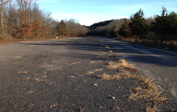
Tim the roving UHub photographer took a walk this morning on the only part of the Southwest Expressway that actually got built - a short stretch north of that weird, semi-cloverleaf where 95 joins 128 - from which it was supposed to head north through Hyde Park (with an interchange replacing Paul's Bridge), Roslindale, Jamaica Plain and Roxbury before joining with the Inner Belt roughly where the Ruggles T stop is now.
Topics:
Free tagging:
Ad:
Support Universal Hub
Help keep Universal Hub going. If you like what we're up to and want to help out, please consider a (completely non-deductible) contribution.
Comments
fascinating
I live near here and was completely unaware. Is there a walking path to get out there?
More info on the failed highway:
http://www.bostonroads.com/roads/southwest/
absolutely...
Fowl Meadow trail head near the intersection of Brush Hill and Neponset Valley Road...if you follow the Burma Road (basically a berm through a vast wetllands that follows a 2- mile length of pipe) all the way to the end where it intersects 95, you can get to the place where the on-ramps were constructed and disappear into the woods (thankfully, no further). White-tailed deer survived the Blue Hills hunt (saw two this morning; frequented by walkers, birders, coyotes and occasional old guy on a mountain bike. Highly recommended.
My dog and I try to
My dog and I try to incorporate that stretch into our morning run almost every Friday.

Always seems vaguely post apocalyptic.
Edit: I would point out that the ramps are also accessible by trail from the parking area at Little Blue Hill on 138.
great pic.
apocalyptic: was just thinking that yesterday a.m. (keeping an eye out, so to speak, for zombies); had the x-pressway gone thru, I think it would have hastened the apocalypse for Hyde park, Rozzie, JP, and Lower Rox anyway
I have to ask ...
Is this stretch in Fallout 4 (and was it completed in that alternate timeline/universe)?
I ask because my son managed to find his way into Lexington from Bedford by locating the Bedford Depot and following what were still the train tracks down what we know as the Minuteman Bikeway (which he rides fairly often).
If you google the DCR and
If you google the DCR and Blue Hills Reservation, I believe you will find a trail map which includes that area.
not to scare you...
but a friend of mine went on a hike thru blue hills yesterday, and ended up with roughly 20 ticks between her and the dog...
Oh, yeah. The ticks have been
Oh, yeah. The ticks have been terrible in the Blue Hills this fall.
good reason to stay on a bike!
When construction of the Southwest
Expressway was cancelled, the interchange between I-95 and I-95/128 remained a full cloverleaf for almost two years. The I-93 south to I-95 south movement was changed to the current 'outside' trumpet in late 1976 to eliminate the dangerous weave between traffic coming from I-95 north and traffic going to I-95 south.
The current "death ramp" movement from I-95 north to I-95/128 north is proposed to be replaced with a flyover ramp - see http://www.massdot.state.ma.us/highway/HighlightedProjects/cantoninterch...
Once the work is completed, ownership of the roadway immediately north of the interchange will revert to the DCR, who will then restore the area to its natural state.