Hey, there! Log in / Register

Back in the day, they checked Boston's boundary markers regularly to make sure nobody moved them
By adamg on Mon, 03/26/2018 - 11:26am
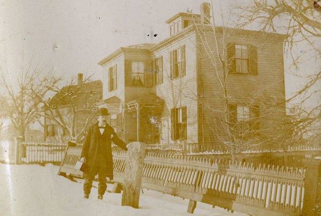
The folks at the Boston City Archives wonder if you can figure out where this city official was "perambulating the boundaries" - checking the markers that delineated Boston from its neighbors. See it larger. Hint: He's not at Marker 123 on the Hyde Park line.
Neighborhoods:
Topics:
Ad:
Support Universal Hub
Help keep Universal Hub going. If you like what we're up to and want to help out, please consider a (completely non-deductible) contribution.
Comments
For some reason
I want to say in JP, right next to the monument on Centre St
The one on the right
Looks like it could be Washington Street on the Brighton Newton Border.
If we all took one.....
https://www.google.com/maps/d/viewer?msa=0&mid=1tVpPT0ptWYbyP3axbkRoLcqz...
.... I would not waste a few hours :)
Hey I made this!
I made that map years ago when Uhub posted a similar photoset. I should go and try to find some more...I tried to find a couple along the riverway near where the daylighting was recently completed but couldn't, probably got destroyed or moved in the construction. I should go back out and try to find more some weekend...
Worth noting that anyone with a google account can edit that map and add photos/info of boundary stones that you may find.
I found a few earlier today using Goggle Street View
It's a cool map, I might go out into meatspace with it some time and look for more.
Maybe just displaying wrong?
When I bring that Google map up, it shows things in odd places and is missing obvious stones like the one on Harvard Ave in Allston and the one across from Faulkner hospital. Is it just me?
possibly
since it is editable by anyone, things go missing occasionally. Feel free to add/move markers if they're in the wrong spot. I check on it every so often and move the ones that I see got moved by mistake.
Across from Faulkner Hospital...
... where is this marker exactly? For example, the bus shelter across from Faulkner on Centre St is roughly a half mile inside the border, so I'm curious.
I found the stub of #20 today
It is at the edge of the lot of 744 Washington Street (address on the Boston side), between the house lot and the driveway.
I don't do Twitter, Google accounts, etc. How might I upload some photos and info to you?
I will try to make the photos public via TinyPic shortly.
Here's two photos of #20
I got the street number wrong above: it's #733 Washington (from the Boston side)
Note that TinyPic presents the close-up pic sideways for some inexplicable reason:
20 CU: http://i66.tinypic.com/25tknpd.jpg
20 wide: http://i63.tinypic.com/10879xk.jpg
I release these into the public domain. Anyone who can edit the Google map is free to add them to it. I might start my own account.
Thanks!
I've added them to the google map. Appreciate it!
Perambulation History Podcast
Link to HUB History podcast on perambulation (which acknowledges our own Adam Gaffin for raising awareness of the concept):
http://www.hubhistory.com/episodes/episode-44-perambulating-bounds/
Somerville boundary stones
Many of these still exist, especially on and near the Tufts University campus. I took some photos a few years ago (with a low-quality dumbphone) and also made
a map of the stones I found. There was also a discussion on Davis Square LiveJournal.
Medford's stones
Apparently there were some, but much of the borders of Medford are various types of water - Mystic Lakes, Mystic River, Malden River, tidal lands, Spot Pond, several brooks, etc. The Mystic has been straightened out, but some oddities with the Somerville borders remain due to former oxbows, tidal flats ,etc.
http://www.perseus.tufts.edu/hopper/text?doc=Perseus%3Atext%3A2005.05.00...
Displaced Somerville-Medford boundary marker?
This one is near Whole Foods, but doesn't seem to be where it belongs, as it's entirely inside Medford by a block or so.
River wander
That section of river was tidal up to 1911, and prone to wandering in its banks.
What was considered the colonial border may not have become the settled border when the river was channelized and straightened as the salt marshes receded.
I just cheated I think
But I just googled "City of Boston Boundary Markers" and I came across a link to scanned copies of the 1896 and 1902 books that have these photos (hosted by the CoB Archives) .
https://groups.google.com/forum/#!topic/westroxburyma/F-ZtwL5MUzI
These photos are from the 1896 Perambulation (https://www.flickr.com/photos/cityofbostonarchives/sets/72157629118996704/) and are markers 21 and 22, which are down in Brighton, near Oak Square. #21 is near the intersection of Tremont and Cufflin and #22 is on Nonantum not too far away from 21.
History?
Do they not still do this? When I lived in southern NH in the 90s, the town selectmen would annually "perambulate the bounds," meeting selectmen from neighbouring towns at the stones to verify their placement.
The Answer
Thanks for playing folks.
These markers mark the Newton/Brighton line.
You can see a map of the area showing the markers here: https://www.flickr.com/photos/cityofbostonarchives/8366993465/in/album-7...
And here's a scan of the entire page from the book, with a few others photos: https://www.flickr.com/photos/cityofbostonarchives/8368060138/in/album-7...
This book is dated somewhere between 1896-1902. We think its probably closer to 1902.
Known as "beating the bounds" in the English Church
This is known as "beating the bounds" in the English Church, whereby the parish boundary was walked so the location of the bounds remained annually present in the parish corporate memory. It frequently occurred during Rogationtide and could involve a liturgical procession of thurifer, crucifer, lights, choir, clergy, village officials, and parishioners, singing the Litany of the Saints (perhaps the Great Litany) and other prayers.
Wayland-Sudbury boundary stone
I took this photo a few weeks ago while exploring the future Wayside (Mass. Central) Rail Trail.
Corporate boundary markers
These exist all over the place, to mark boundaries between cities/towns and counties. Many/most? are maintained by USGS, and so they show on USGS topos. They're really useful if you want to practice map and compass skills: navigate this line and you should find this boundary marker, out in the middle of the woods somewhere.