Hey, there! Log in / Register

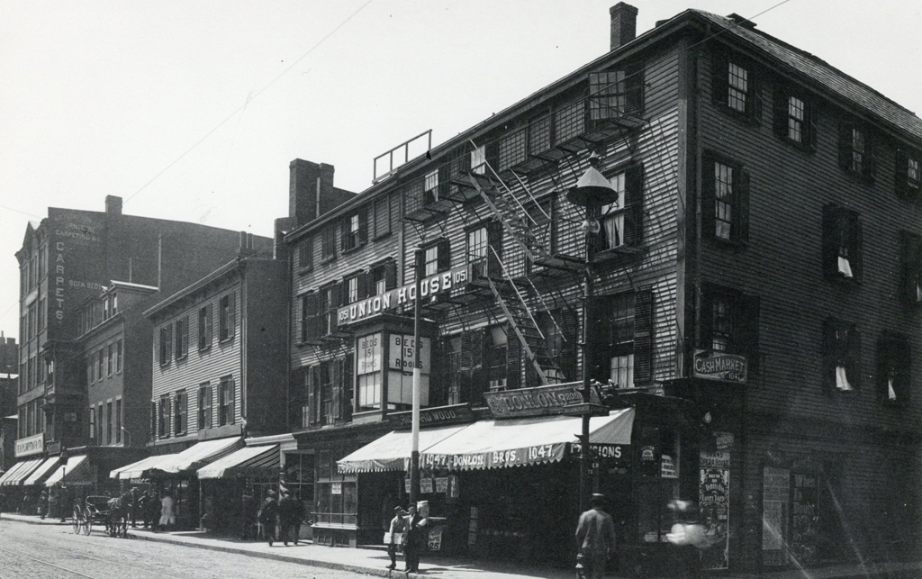
Just 15 cents a night for a bed at the old Union House
By adamg on Wed, 06/02/2021 - 10:22am

The folks at the Boston City Archives wonder if you can place this scene. See it larger.
Neighborhoods:
Topics:
Ad:
Support Universal Hub
Help keep Universal Hub going. If you like what we're up to and want to help out, please consider a (completely non-deductible) contribution.
Comments
1047 Washington St
If Eeka Is Right
This building is right where the phone company warehouse is on Washington across from Traveler Street with the Borg Cube church on Shawmut being just out of the frame to the right.
ye not so old
union house
15 cents for the bed
and 25 cents for companionship.
The corner of
Washington and Cherry Sts, probably before 1908.
Washington St in the South End/Shawmut area
https://alpha.mapjunction.com/?lat=42.3452531&lng=-71.0651248&clipperX=0...
You can see the Union House boarding house mentioned in the 1917 atlas between Cherry St (now an alley/private driveway) and then Compton St (now gone completely).
The block was also the Shawmut Substation after purchase and transformation by the MBTA in the late '70s. It now appears to be owned by Robert Gottlieb as part of the same parcel as the parking lot next door. A 2002 land survey had it as the NE TeleCo service garage but I can't find anything to validate what it is today yet.
There are some interesting old newspaper clippings online regarding that boarding house. One in which a jewelry thief from NYC was using it as a local home away from home and another in which two seemingly unrelated gentlemen simply dropped dead in the middle of the night there.
You can also find an old classified ad from the Donlon Brothers looking to sell their cash register as they were getting out of the goods business in the late 1890s.
Wait... Albany Street?
That area of the northern South End (NoSoWa?) sure had a lot of streets before urban renewal bulldozed it all. But looking at the now gone streets led my mind to wander and notice that the roads in what's now the Ink Block used to be named after various destinations in upstate New York. Which makes me realize: oh was Albany St named after the Boston and Albany Railroad? Looking at the older maps they seem to have been built around the same time around the area of what would end up getting consolidated into South Station and then Albany St gradually extended its way in a different direction down the South End to Roxbury as more landfill was built there. Even today, Chinatown and the Leather District have a few New York streets too.
More subtle than Old Colony Ave.
Harrison Avenue
Was called Front Street (as in waterfront) when laid out.
Was changed after President Harrison decided he didn't need a coat at his swearing in and died.
Yes, the New York Streets were all named for New York towns where the railroad was going to reach.
Old Colony Avenue was named because it used to be a railroad that was abandoned when South Station was built. The lines consolidated on the present line which runs south from South Station.
The Answer
Thanks for playing, folks! Washington Street is correct! Date is 1899