Hey, there! Log in / Register

Keeping Boston Harbor from reclaiming much of the downtown waterfront could require raising the Harborwalk, installing new pumps, pipes and tanks, report says
By adamg on Sat, 06/03/2023 - 12:45pm
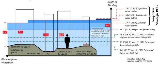
Glub: A man who never moved from the Custom House would need air tanks in a storm by 2070, report says.
A report released by the Wharf District Council, which covers the downtown waterfront between the North End and Fort Point Channel, says the area is going to need extensive work, costing hundreds of millions of dollars, to keep it from turning into a permanent extension of Boston Harbor as sea levels continue to rise.
As first reported by Banker & Tradesman, the report lays out the problem - within seven years, a major storm could leave much of the area underwater, even more so than a 2018 storm in which Atlantic Avenue and Seaport Boulevard lived up to their names. Even without storms, downtown residents and workers can expect to see more "sunny day" flooding from harbor water percolating up through storm drains, as now sometimes happens on Long Wharf near the Chart House.
MBTA photo of Long Wharf flooding in the 2018 storm:

The report calls for studies of a series of steps, including turning the Harborwalk into what would basically be a series of berms topped with a walkway, new seawalls and even planted area on the water side of the Harborwalk, installation of beefier pumps, tide gates and other systems to quickly pump out storm water and a separate series of underground tanks along the water to hold increased rainwater, as well as inflatable barriers along Atlantic Avenue that could rise five feet to minimize damage from storm surges.
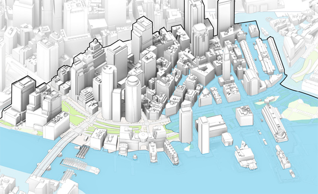
In just seven years, half of the downtown waterfront would flood in a major storm, report says:
The report suggests replacing the current dysfunctional Northern Avenue bridge with what would essentially be a large seawall topped by a pedestrian walkway. In a separate report a consultant hired by the Boston Water and Sewer Commission recently suggested building a Providence-like flood wall where Fort Point Channel meets the harbor, the goal of which would be to protect areas further inland that were once part of South Bay.
Ultimately, the decision on what to build could rest with the Army Corps of Engineers, which has signaled it plans to study how to protect Boston from rising sea levels and more intense storms now that planning is underway for a system to protect New York City.
Neighborhoods:
Topics:
Free tagging:
Ad:
Support Universal Hub
Help keep Universal Hub going. If you like what we're up to and want to help out, please consider a (completely non-deductible) contribution.
Comments
We can’t even replace
The Cape Cod bridge. I’m sure this will be build by late 2200.
Does not seem so smart to be
Does not seem so smart to be building so much new stuff in the flood zone, but its OK, in the end the taxpayers will bail out the banks.
Or, just spitballing here, we
Or, just spitballing here, we could send the bill to the oil supermajors.
Magoo sez
Egagagagoooooo! Magoo.
So, turning it back into the
So, turning it back into the harbor. Too bad we cut down some hills back in the day.
Great for construction companies!
What happens when construction companies are not able to persuade the BPDA to destroy good solid buildings? Granted the BPDA masters never saw an attractive building they believed worth keeping, but eventually the city will run out.
I'm thinking specifically of the destroyed building that stood at Arlington and Boylston. A structure a thousand times more attractive than the box of shlass (a glass box equal to a pile of dung) that will will rise in its place.
Sarcasm aside this could turn out to be one of the rarer instances of not waiting until the worse happens to actual deal with a major problem.