
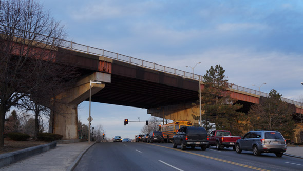
The blizzards may have slowed the work, but there's no mistaking the Casey Overpass is coming down: Trees all around it have been chopped down, there's a new road and sidewalk on the bus-depot side and construction equipment is everywhere.
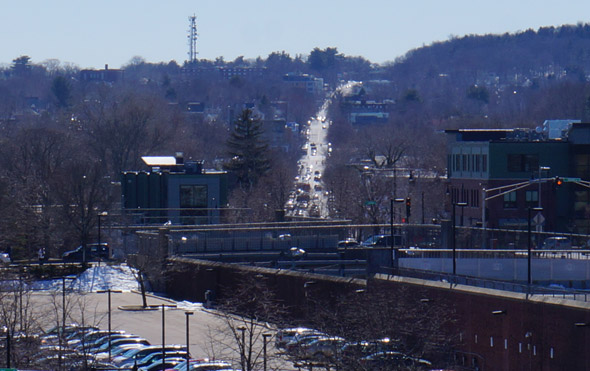
There are some pretty nice views up there, which will disappear with the overpass - unless you happen to have a drone - from Forest Hills and Roslindale on one side to Jamaica Plain, Roxbury and the Back Bay on the other. In January, just before the first blizzard, I walked up along the bus-depot side of the overpass. Returned yesterday with the kidlet to find that sidewalk is now blocked off. Fortunately for us, the sidewalk on the T-stop side of the overpass remains open for now. Here are some photos from the two walks.
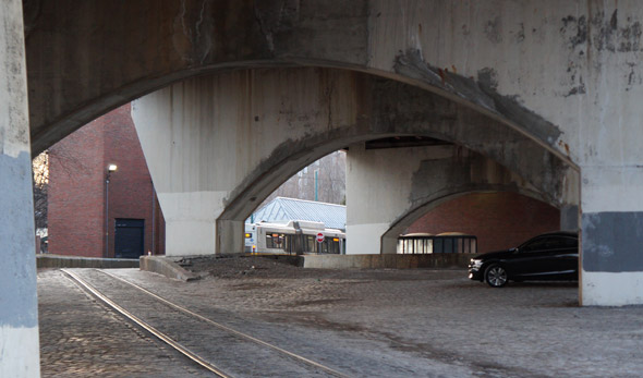
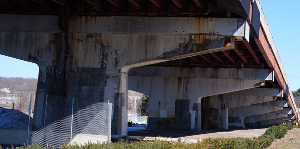
Yeah, the overpass is in rough shape - which you can see both at the top, where the four lanes have been reduced to two, and from below:
The overpass is pretty curvey:

The main reason for the overpass was to get cars over the elevated that used to go down Washington Street - where there's now just a lot of space:
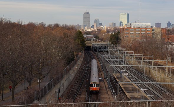
The Green Line used to go under the overpass, too:
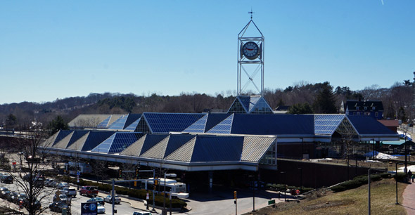
The trolleys used to sleep at night at the Arborway Yard, which these days is a "temporary" bus yard next to the overpass. You can also see (from left to right) the old Jamaica Plain High School, English High, the Pru and the Hancock and the round senior-citizen apartment tower in Egleston Square (See it larger):

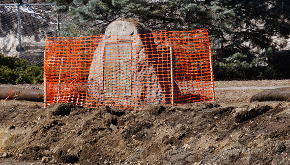
One thing that won't be moved during the construction, at least not initially, is the memorial to the "Men of the Jamaica Plain Car Barn Who Served in the World War:"
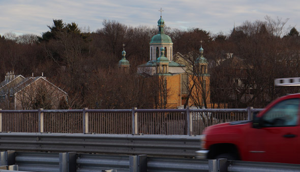
You get a good view of the Ukranian Orthodox church from the overpass:
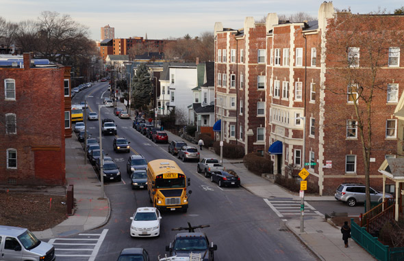
One thing that surprised me was just how much of a hill Washington Street goes up in Roslindale:
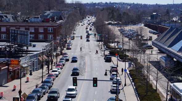
By comparison, South Street and Hyde Park Avenue are relatively flat:
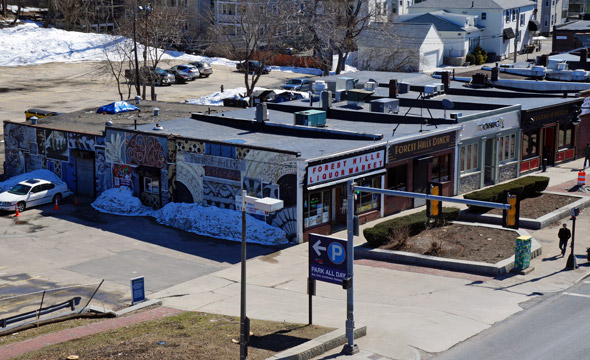
Across from the liquor store is the Forest Hills T station:
Going down:
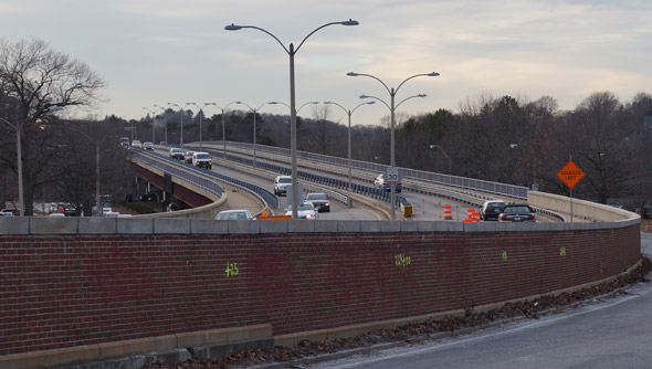
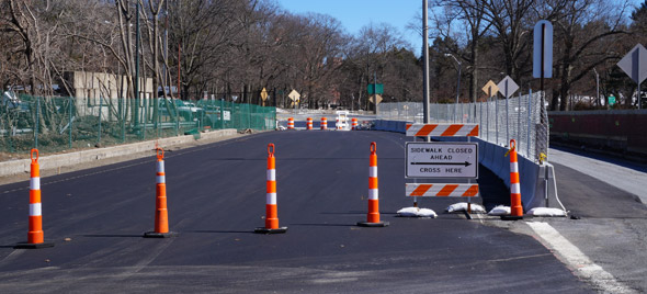
New, temporary road, to carry traffic between the time the overpass comes down and the new surface roads are ready:
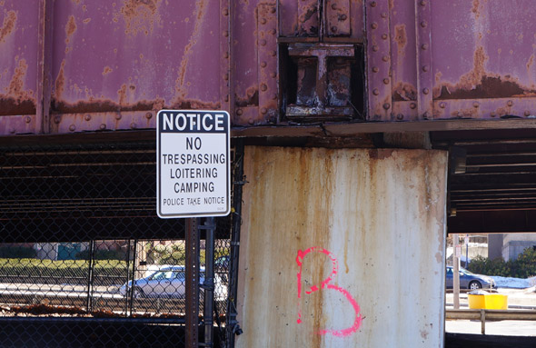
And, as always, no camping allowed under the overpass.
Like the job UHub is doing? Consider a contribution. Thanks!
Ad:
Comments
Ah, the nostalgia
By Waquiot
Mon, 03/30/2015 - 10:03am
Yes, the thing is structurally unsafe and needs to come done, and yes, I am predicting gridlock even when construction is done, but in my heart, I'll miss the old thing. The configuration of the area when it was built, coupled by the grade change from the Arboretum to Franklin Park, made the views from the top amazing and, in my controversial view, I never felt the overpass overwhelmed the streetscape a la the Central Artery or even the elevated roads south of Chinatown built when the highway was buried.
The overpass served it purpose for the length of time it was built for. We'll see how things work out. Thanks for the photos.
I hear you.
By Sally
Mon, 03/30/2015 - 12:28pm
Though I suspect it'll be like looking at the photos below of the old Orange Line--despite a certain charm, the replacement will be better, cleaner, brighter.
I get nostalgic for the scenes I never knew, like the old Green St. station which just looks so stately and solid (you can see the photo if you scroll down) http://www.jphs.org/victorian/reminiscences-of-jam... .
You might like these shots too
By 500Monkeys
Tue, 03/31/2015 - 11:37am
http://arborwaymatters.blogspot.com/2013/09/under-...
Under the Overpass: A Visual History
Courthouse parking
By BB from Dot
Mon, 03/30/2015 - 10:09am
What are the plans for courthouse parking once the overpass comes down? It seems like a lot of cars are under there every day.
Space by the old MBTA building, I think
By adamg
Mon, 03/30/2015 - 10:36am
That office building between the overpass and the bus yard.
Courthouse parking
By 500Monkeys
Mon, 03/30/2015 - 3:14pm
Pretty sure this is going to now be in a new (temporary?) lot off Washington within the bus yard.
What Court House?
By Justice For All
Tue, 03/31/2015 - 12:28am
For those not aware, with the exception of some small claims and miscellaneous filings, the courthouse will be greatly reduced. It already moved its docket case load to other court houses back in January in anticipation of the construction - notably to Brighton.
Has MassDOT announced a final closing date for the overpass?
By Ron Newman
Mon, 03/30/2015 - 10:09am
I'd like to take one final bike ride over it (and maybe other folks would like to organize that more formally).
Weather permitting, end of May
By adamg
Mon, 03/30/2015 - 10:39am
Based on presentation at March meeting. I don't think they have a specific date yet.
End of May
By BikeWithKids
Mon, 03/30/2015 - 10:42am
We were told at the first Casey Construction Meeting that the Casey will be completely shut down by the end of May. All vehicles will utilize surface streets, by the end of May.
Demo of Western Abutment first
By 500Monkeys
Mon, 03/30/2015 - 3:21pm
Page 13 of the presentation Adam linked to above says the demolition of the western abutment (between South Street and the Arboreturm, the westbound lane on the northern side) will begin in mid-April - so some portions will be closed sooner than others.
Before that, the westbound overpass traffic will be diverted to the new temporary surface lanes. Once that portion is demolished, the rest of the overpass will be closed and the eastbound overpass traffic will be diverted to the surface where the western abutment was... yes: by end of May.
Here's what confuses me
By Waquiot
Mon, 03/30/2015 - 3:39pm
I view the bridge traffic as east-west.
There is one abutment per section so how can they demolish half of the abutment?
Unlike my criticism of the plan, I accept that there must be a way to get the bridge down, but I am scratching my head about this.
I suppose at the end of the day, I'll see how this works. Still seems odd to take down have an abutment.
One cheek of the abutment
By 500Monkeys
Mon, 03/30/2015 - 5:30pm
I dunno exactly how they're going to do it, but... they do!
The plan as described in the Staging documents is to first close the westbound overpass lane sending its vehicles to the temporary surface lanes being created now, then demolish the westbound (northside) half of the western abutment between South and the Arboretum - carefully, quickly, using giant pinching shears to cut the steel girders into truck size chunks and cart it away without releasing lead-paint toxins into the atmosphere as they might with blow torches... and then presumably use bulldozers and loaders for the earthen/brick part of the abutment. As I understand it, one side of the hammerhead pier top will be removed leaving the base intact for a while. When they've removed that half, they're going to create a temporary eastbound surface lane where that was for the use of what was the eastbound Overpass traffic - the exit ramp by the Arboretum will continue as it is now for a while. Then they'll close the rest of the overpass so they can demolish what's left in the months after. It will look pretty wild for a while - the tallest spans over Washington go last, I think.
I'm gong to trust the engineers
By Waquiot
Mon, 03/30/2015 - 7:40pm
At least the demolition engineers. As you know, the jury is still out with me and the traffic engineers.
With any luck, the demolition
By anon
Tue, 03/31/2015 - 12:53am
With any luck, the demolition engineers are more competent than the design and maintenance engineers who allowed the overpass to end up in an unrepairable condition.
Yes, clearly the fault of the engineers.
By Sally
Tue, 03/31/2015 - 10:47am
Who designed it 60-odd years ago. Just let it go already.
Thanks for the photos!
By anon
Mon, 03/30/2015 - 10:28am
I'll miss the panoramic views, too. I realize now that those are what I most valued about the overpass.
Great photos
By cw in boston
Mon, 03/30/2015 - 10:34am
I, too, am surprised by the hill on Washington St. Now I have to pay attention next time I drive that way.
The overpass lost a lot of charm when they removed the bricks some years ago. It is the end of an era, and I hope for the best with the at-grade solution.
Thanks for posting the pictures.
As a runner, I'm painfully
By chaosjake
Mon, 03/30/2015 - 11:26am
As a runner, I'm painfully aware of the two big bumps heading outbound on Washington out of Roslindale Square. The first tops out near Pet Cabaret, and the second is right at Washington and West Roxbury Pkway. That second hill is a shoulder of Bellevue Hill, the highest point in the City of Boston. There's a little park and trails that lead up to some water towers on top. It's worth walking up just to say you've been tot he highest point in Boston.
The key is
By Waquiot
Mon, 03/30/2015 - 12:21pm
Not to run up those hills.
I do tackle those hills, but downhill only. I run to Dedham via Hyde Park, then face a rise over the course of 2 or so miles on Bussey/Grove Street and Washington Street, ending with the drop from High Point to the Square. I am always amazed when I pass people going the other way.
Nah, I always do it the other
By chaosjake
Mon, 03/30/2015 - 1:09pm
Nah, I always do it the other way. I like to run up Bellevue on either Washington or Liszt (parallels the W Rox Pkway) then back down Washington to Grove/Bussey to my house in Readville at least once a week. And always in the second half of the run, when I'm nice and tired. If I'm really feeling frisky, I'll go up the right side of W Rox Parkway and over the second-highest trail in Bellevue Hill park. Yesterday I hit the top just short of mile 20... because I'm not a sane man.
Oh, that reminds me of another thing
By Waquiot
Mon, 03/30/2015 - 10:53pm
The BAA Half Marathon is going to have a section that will be worse than before. The grade of the overpass was easier than it will be, assuming they will still start/finish it at Franklin Park.
front row seat
By neuroboy
Mon, 03/30/2015 - 10:35am
I statrted a new job right next door to Forest Hills a month ago. It'll interesting to have a front row seat (and a before/after view) of its demolition. Thankfully I'm not driving around here. I'm guessing the construction will snarl things up real good.
Apartments nearby for cheap!
By MassMouse
Mon, 03/30/2015 - 10:40am
I'm currently looking for a better home to live in, and keep laughing at the ads for South Street near the MBTA station. You could not pay me to live there over the next few years!!
Worry not, you won't be paid
By anon
Mon, 03/30/2015 - 3:58pm
Worry not, you won't be paid to live there, plenty of people will pay to live there. Do you live in Boston now? In the past 8 years, I have had 3 apartments and during each time, a pretty large construction project occurred across the street or behind us, after we moved in. Its part of living in the city, especially during a strong economy where lots of construction is going on.
Washington St.
By gradontripp
Mon, 03/30/2015 - 11:17am
I used to ride the 34E between Roslindale Square and Dedham, and was always impressed with the skyline view between Enneking and Beech St. I'm surprised that, when they redid the Washington Beech housing, some greedy developer didn't cut a deal with the BRA to put a more "market friendly" development there.
The houses on Metropolitan
By chaosjake
Mon, 03/30/2015 - 11:28am
The houses on Metropolitan Ave just uphill from Washington also have million dollar skyline views.
Amazing
By Darryl
Mon, 03/30/2015 - 12:11pm
Spot on, I like driving slow by those houses to gasp at the great view they have.
Thank you!
By Sally
Mon, 03/30/2015 - 12:24pm
Fascinating. Parts of it are so beautiful and parts...well, you can't but be grateful it's gone. Amazing to imagine Blackstone square bisected by the Elevated...
4th of July Fireworks
By Michael Kerpan
Mon, 03/30/2015 - 12:55pm
That is our spot for watching fireworks -- breezier, less bugs, not as noisy as down by the river -- and a pretty decent view of the fireworks, exceopt for really low-level ones.
Bellevue Hill
By Jason
Mon, 03/30/2015 - 11:21am
As Washington Street goes uphill outbound through Roslindale, it climbs up to pass by Bellevue Hill, just after the intersection with West Roxbury Parkway.
https://en.wikipedia.org/wiki/Bellevue_Hill,_Boston
Bellevue is a serious hill climb
By Ron Newman
Tue, 03/31/2015 - 8:19am
The 50-mile route of the annual Hub on Wheels bike tour climbs it from the Bellevue Hill Road and Lagrange Street side. It's sufficiently steep and grueling that many people get off their bikes and walk up.
Descending the other side is fun, on that narrow winding paved path through Stony Brook Reservation.
Bummer! I too will miss the
By anon
Mon, 03/30/2015 - 11:46am
Bummer! I too will miss the views and am not looking forward to being stuck in traffic on the surface streets. This is what the neighborhood and cyclists wanted though so I hope it works out for them.
But
By Neighbor2
Mon, 03/30/2015 - 11:46am
But gee, the Long Island bridge was demolished within - it seems- 48 hours of being condemned. Seems like we can get things done quickly when there's
something to hide,a really urgent needjust water underneath.wut?
By anon
Mon, 03/30/2015 - 1:06pm
wut?
They condemned the Long Island Bridge last October. Just last week they were still demoing parts of it. There are still more spans to remove, too.
Fun Orange Line Site
By Darryl
Mon, 03/30/2015 - 12:14pm
If you are interested in seeing what the area looked like when they were building the overpass, check out: http://theelevated.org/. You'll have to scroll for a bit, but many of the photos that are there show the old Forest Hills Station (which was where the parking lot for the lower bus terminal is currently).
If rust and water damage
By anon
Mon, 03/30/2015 - 12:46pm
If rust and water damage means bridges have to come down and everything needs to be rebuilt at grade, I'm not looking forward to the new Porter Square after they demolish the commuter rail underpass and Red Line station and have them both run in the street.
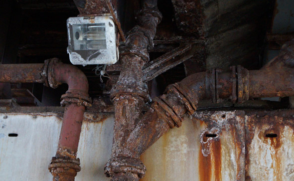
There's more wrong with the overpass than just some rust
By adamg
Mon, 03/30/2015 - 12:52pm
I photographed that because it makes for an interesting photo, but there's a lot more wrong with the thing.
And there's a lot more wrong
By anon
Tue, 03/31/2015 - 12:47am
And there's a lot more wrong with the Porter complex than some rust.
There's a continuous waterfall flowing down the wall and onto the subway tracks.
And the Mass Ave bridge over the Commuter Rail is a mess. The platform under there is a perpetual salt lake because of all the water infiltration.
How does the water get down there
By Waquiot
Tue, 03/31/2015 - 9:09am
It's the deepest station in the system, so it's not like we are talking Broadway or Copley.
That waterfall is probably just a failing retaining wall, not the bridge. The bridge will probably be okay, but the Red Line will eventually shut down north of Harvard if they don't do anything about that.
Nobody's demolishing the
By chaosjake
Mon, 03/30/2015 - 1:11pm
Nobody's demolishing the Orange Line and Commuter Rail underpasses at Forest Hills and having those run in the street either.
All analogies must be
By anon
Tue, 03/31/2015 - 12:50am
All analogies must be perfectly analogous, or else they'll be rejected by the Central Transportation Analogy Bureaucracy.
Thank god...
By thanksbrah
Mon, 03/30/2015 - 2:31pm
thank god our lease is up July 1, need to get the hell out of here. It's going to be a disaster, we only have one way to get out of our street (Morton St) and for the next 2-3 years it will be impossible.
I'm hoping each day our LL raises the rent so I can have a big ol' laugh
Washington St. Hill
By HenryAlan
Mon, 03/30/2015 - 8:37pm
Yeah, never realized that until I started biking it. Serious elevation climb from the car wash to High Point Village. Fortunately, I only have to bike as far as the square, which is bad enough.
Add comment