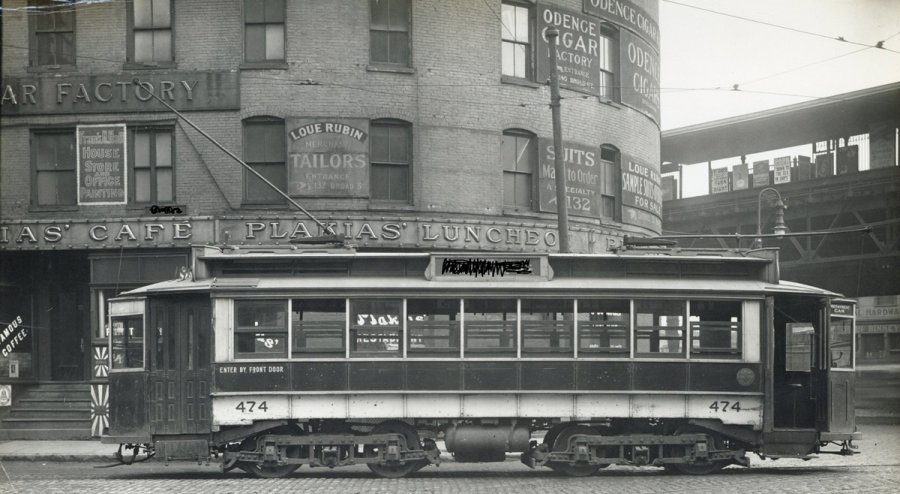
The folks at the Boston City Archives wonder if you can place this scene (some details that would make it obvious scribbled out). See it larger.
Neighborhoods:
Topics:
Like the job UHub is doing? Consider a contribution. Thanks!
Ad:
The folks at the Boston City Archives wonder if you can place this scene (some details that would make it obvious scribbled out). See it larger.
Like the job UHub is doing? Consider a contribution. Thanks!
Ad:Help keep Universal Hub going. If you like what we're up to and want to help out, please consider a (completely non-deductible) contribution.
Comments
Broad & Atlantic?
By bibliotequetress
Fri, 01/20/2023 - 12:22pm
Where the Panera is, maybe? Guessing because of the el tracks-- where would they be visible from Broad Street.
Good guess.
By Section 77
Fri, 01/20/2023 - 12:48pm
I'm assuming you didn't see the sign that says 132 Broad st.
They didn't do enough scribbling
By Ari O
Fri, 01/20/2023 - 1:45pm
Sure, the trolley car sideboard is scribbled, but they left a lot of Broads in there!
I could see Broad but I
By bibliotequetress
Fri, 01/20/2023 - 9:05pm
I could see Broad but I couldn't make out the number.
Good guess.
By Section 77
Fri, 01/20/2023 - 2:23pm
I'm assuming you didn't see the sign that says 132 Broad st.
Rowe's Wharf station
By Charles Bahne
Fri, 01/20/2023 - 2:55pm
Yes, that's the Rowe's Wharf elevated station at right, which was on Atlantic Ave. at the junction of Broad.
The site would actually be where the Greenway is today.
Car 474
By Ari O
Fri, 01/20/2023 - 1:48pm
Built in 1903, last ran in 1930. A sibling (car 475) became a work car and was eventually preserved at Seashore.
The Answer
By Boston City Archives
Sat, 01/21/2023 - 10:39am
Thanks for playing, folks! Yes, this shows 132-140 Broad Street at Rowes Wharf. We're dating the photo between 1900-1915, based on the trolley car and business signs. You can see a high res version of the photo here: https://cityofboston.access.preservica.com/uncateg...
Add comment