
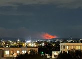
BostonTimelapse looked out of his South Boston window towards the Blue Hills Reservation around 7:50 tonight and saw the red-hued smoke from brush fires in the park. He reports that an hour later, the fires, or at least the glow from them, had died down. Read more.
By adamg - 11/17/24 - 11:10 pm
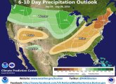
The National Weather Service's Boston-area office says an end to our "red flag" days could be coming mid-week: Read more.
By adamg - 11/10/24 - 12:35 pm
The Crimson reports the prolonged drought has been drying up Cambridge's reservoirs, leading to officials urging residents to conserve water - like by taking shorter showers. Worst case, Cambridge could buy water from the MWRA, which has larger, still relatively plentiful water sources out west, but that water would cost more.
By adamg - 11/9/24 - 3:36 pm
NBC Boston reports more than 100 acres of woods burned overnight in Lynn.
The National Weather Service has a red-flag warning up for the entire state, until 6 p.m. on Sunday. There's a chance of rain after that and through Monday.

By adamg - 8/1/22 - 1:48 pm
It's got to be frustrating to be a Millennium Park beaver these days: There's just not enough water to dam up along the Charles, but especially in Sawmill Brook, which no longer empties into the Charles because it no longer flows. This morning, Mary Ellen spotted this once eager beaver forced to waddle across mud and what's left of the water.
Update: Mary Ellen posted video showing that the little guy was able to get a bit of a swim in.

By adamg - 7/31/22 - 2:29 pm
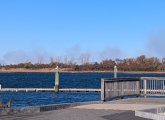
Gio Valencia watched a couple of kayakers walking their craft down the deepest part of the Charles River by Millennium Park in West Roxbury. The river's normally pretty shallow in that stretch, but the current drought has reduced it to a shallow creek there.
By adamg - 7/29/22 - 4:07 pm
The level of the Charles River where Millennium Park in West Roxbury meets Cutler Park in Dedham and Needham is now so low that somebody who doesn't mind getting their calves wet - and maybe sinking into some mud - could easily wade across at its narrowest points. Read more.
By adamg - 4/13/17 - 9:06 am
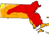
The latest state drought map shows just 0.15% of the state is still in drought, while 52% of the state is "normal," and the rest - including the area around the Quabbin Reservoir - is "abnormally" dry. At the peak of drought conditions last year, pretty much the entire state, save Nantucket, was considered to be in a drought, with some areas in "extreme" drought.
By adamg - 1/26/17 - 8:51 am
The newest Massachusetts drought map shows eastern Massachusetts is now in a "moderate" drought, down from the "severe" drought we were in just last week - and the "extreme" drought in September.
By adamg - 11/3/16 - 9:58 am
The weekly drought map is out and shows Boston is now in a "severe" drought, rather than an "extreme" one. The portion of Massachusetts still in "extreme" drought has shrunk as well.
BWSC rain totals show a monitoring station on Adams Street in Dorchester got nearly 6 inches of rain last month, more rain than the station saw in June, July, August and September combined.
By adamg - 10/17/16 - 12:06 am
The Cambridge Water Department turned on the spigot for MWRA water this month because of the drought that has dramatically reduced levels in its own reservoirs along Rte. 128. Read more.
By adamg - 10/7/16 - 9:41 am
That rain a few days ago wasn't enough wasn't enough to break the drought's grip on Massachusetts.
By adamg - 9/22/16 - 9:00 am
The latests Massachusetts drought map, updated this morning, shows the weekend rains failed to change much.
By adamg - 9/16/16 - 9:24 am
WBZ's Eric Fisher runs the numbers, says the drought actually started in the winter of 2015, you know, the endless winter and all, because while we got snow UP TO HERE, it was incredibly "dry" snow with little actual moisture in it.
By adamg - 9/15/16 - 1:44 pm
The weekly state drought map now shows that more than half the state is experiencing an "extreme drought."
Things have gotten so bad in Worcester the city is now spending $1.7 million a month to buy water from the MWRA, which still has plenty of water in the Quabbin Reservoir.
By adamg - 8/30/16 - 10:22 am
Our local National Weather Service office isn't holding out much hope for much rain over the next ten days or so, so looks like none of the tropical storms brewing in the Atlantic will help.
By adamg - 8/25/16 - 9:16 am
The weekly drought map shows little change in Massachusetts: The Boston area remains in an "extreme drought" and most of the rest of the state is in a drought as well, except for the extreme western end, which is "abnormally dry."
Scituate, not part of the MWRA water system, is asking residents to limit their shower time.
By adamg - 8/23/16 - 2:47 pm
Many of the buildings sit on wooden pilings that only rot when exposed to dry conditions. The Beacon Hill Times reports on nascent concern in the area about the pilings.
By adamg - 8/21/16 - 2:13 pm
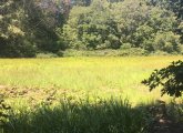
Gedalia Pasternak notes that on a map this field is officially known as Bellevue Pond in Medford.
The National Weather Service says we could get some heavy rain tonight, thanks to a front that is currently over New York state.
By adamg - 8/20/16 - 11:05 am
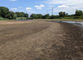
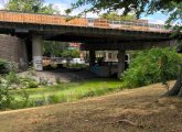
Penny Cherubino went for a walk on the normally green grass along the normally brown Muddy River the other day.
- Page 1
- next ›