
NBC Boston reports (with video of non-aquatic drivers just trying to survive the flood) MassDOT spent the night pumping out the tunnel.
By adamg - 12/12/24 - 9:57 am
Jeremy Reiner reports it's been 1,019 days since the last time Boston has seen six or more inches of snow in a single day, the fifth longest such streak since 1891.
By adamg - 11/17/24 - 11:10 pm
The National Weather Service's Boston-area office says an end to our "red flag" days could be coming mid-week: Read more.
By adamg - 11/8/24 - 5:08 pm
All that rain we haven't been getting has meant dramatically lowered rivers, a statewide "red flag" warning about how easily things can go up in flames and now a state "critical drought" designation for "Massachusetts's Central and Northeast regions, including the Charles River watershed," according to the Charles River Watershed Association:
Streamflow in the Charles River is at critically low levels, with some sections showing zero flow.
By adamg - 9/17/24 - 2:03 pm
The current forecast from NWS Boston shows a chance of rain for Wednesday night into Thursday.
By adamg - 8/19/24 - 10:35 pm
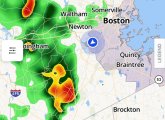
A little after 8, Gary C. called up a Boston weather map on his Storm Radar app and got a map that Dick Albert would've loved. Rogers noticed it, too.
By adamg - 8/7/24 - 10:25 pm
National Weather Service forecasters are saying that Tropical Storm Debby's track has shifted more to the north and west, so the impact on the Boston area will probably Friday into Saturday will probably be relatively minimal: "It appears the threat for significant flooding has shifted west of the region."
By adamg - 8/4/24 - 7:10 pm
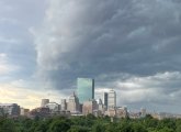
Mark Smith watched the storm clouds roll in over Roslindale Square this afternoon (the Municipal Building and the Greater Roslindale medical clinic building in the lower left).
By adamg - 7/23/24 - 11:00 am
The Supreme Judicial Court ruled today that if it had its way, it would rule in favor of collapsing Steward Health Care System and its property-owning spinoff MPT in a case involving the amount of insurance money they should get for rebuilding Norwood Hospital, destroyed by flooding in 2020. Read more.
By adamg - 6/26/24 - 9:59 pm
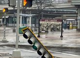
At least three drivers got stuck in the raging floodwaters, well, deeper-than-it-looks lake that formed on Spring Street in front of the Star Market plaza in West Roxbury tonight. Read more.
By adamg - 6/14/24 - 2:09 pm
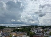
Louise Miller watched the ominous clouds moving over Boston around 1:15 p.m.
By adamg - 4/30/24 - 9:41 am
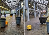
Boy, it sure rained buckets early this morning, huh? In case you managed to sleep through it all, you could still get a feel for just how much rain fell inside Ruggles station, where Handmaid captured some of the many fine barrels the T put in to capture all that water inside the station.
By adamg - 4/4/24 - 9:48 am
Teddy Kokoros recorded the aftermath of a mighty wind at the JFK/UMass T stop this morning.
Damien Drella reports that high winds caused the partial collapse of a four-story section of an apartment building in Saugus. Read more.
By adamg - 4/4/24 - 9:30 am
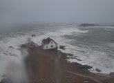
A National Park Service/Coast Guard camera on Boston Light, where the ocean meets Boston Harbor, recorded the sea's ragin' glory at 6:24 a.m.
Photo via Boston Timelapse, which reposts photos from Boston Light, Bunker Hill and Dorchester Heights every hour.
By adamg - 4/3/24 - 3:49 pm
So no snow (so what else is new?), but the National Weather Service has a high-wind warning in place between 8 p.m. and 2 p.m., Thursday, with possible gusts of up to 60 m.p.h. here in the Greater French Toast Region: Read more.
By adamg - 3/8/24 - 3:50 pm
The National Weather Service has issued coastal-flood watches for the entire Massachusetts coast for Sunday morning and afternoon, because of Yet Another Rain Storm that could mean 1 to 2 feet of flooding. Read more.
By adamg - 2/13/24 - 9:51 am
Jamaica Plain News reports the Arnold Arboretum lost some 40 "accessioned" trees, including a dozen hemlocks snapped in half - by a storm in December that brought both rain to already saturated soil and high winds.

By adamg - 1/14/24 - 2:07 pm
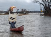
One of these days, years, decades, the state promises to do something about Morrissey Boulevard so it doesn't flood when it rains or somebody spills their iced Dunk's. In the meantime, Savin Hill Sailor shows us yesterday's Second Semi-Annual Morrissey Boulevard Challenge, which involved getting across and along Morrissey Boulevard when cars couldn't. Don't worry: The canoe was equipped with a paddle for when the winds die down or the sailor's arms get tired. Video.
By adamg - 1/14/24 - 1:43 pm
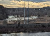
Yesterday afternoon, just before the deluge that gave us That Rainbow, the Long Ditch that connects two loops of the Charles at the Dedham/Needham line (dug by the busy-beaver colonial settlers who also gave us the Mother Brook), had overflowed its banks and was flooding the nearby marshes of Cutler Park. As it was designed to do. Read more.
- Page 1
- next ›