Hey, there! Log in / Register

Did they ever get off of that train?
By adamg on Thu, 12/08/2016 - 11:06am
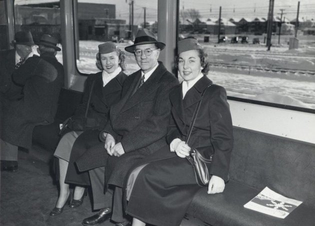
The folks at the Boston City Archives wonder if you can identify these people and what they're up to. See it larger.
Neighborhoods:
Ad:
Support Universal Hub
Help keep Universal Hub going. If you like what we're up to and want to help out, please consider a (completely non-deductible) contribution.
Comments
Given the style of overhead wire
in the background, my guess this is a publicity photo related to the opening of the Revere Extension - now the Blue Line. Likely Orient Heights carhouse in the background.
Seems right
Especially since it seems like the two women are dressed as stewardesses.
Flight attendants, please
'Stewardesses' was used in the 1950s.
Now, the term is 'flight attendants'.
Contemporary term
The photo was taken in the 1950s. The job title of the two women pictured was "Stewardess."
I would say we have a bingo
And the MTA manager noted below. Probably touting the ability to get to the airport via the blue line.
Technically guessing this was the "revere extension", later rebranded the Blue Line. Based on the note below - guessing 1954.
From Wikipedia
From 1952 to 1954, a surface-level extension was constructed along the recently-defunct Boston, Revere Beach and Lynn Railroad, from Maverick to the current terminus at Wonderland. The original trackage had been narrow gauge, but was converted to standard gauge for this Revere Extension of the subway.[6]:51 The first above-ground station on the new extension served Boston's Logan Airport, and was the first American urban transit connection to a commercial airfield.[6]:51 Beyond Maverick, the power feed was changed from third rail to overhead catenary (both at 600 V DC) to reduce the risk of winter ice buildup due to proximity to the ocean.[6]:51
Yes, it wasn't the Blue Line yet
when the photo was taken - thanks for pointing that out. That's what I get for typing before I think - have revised my original posting.
What counts as going "to" an
What counts as going "to" an airport? When the Airport T station opened, not only did you have to take a bus to the terminals like today, but you had to pay a standard bus fare.
However, that bus was undoubtedly faster than today. They understood back then how to build an elevated busway that didn't require traffic lights to connect to the airport roadways. And the recent detour to the Rental Car Center makes things much worse.
"...recent detour to the Rental Car Center makes things much"
I agree that it's at least a little weird on the face of it.
I haven't flown much recently and haven't gone by T when I have. Until you said so (which made me go look it up), I assumed there was one route looping subway & terminals, one looping rental center & terminals. Shows what I (don't) know.
I would point out that the layout of the airport roads means that a bus going from subway to terminal A will pass right in front of the rental car center. It's not a huge route diversion (for people starting from subway), it's just a question of whether it creates undue crowding. It must suck for people picked up at terminals and headed for rental center - stuck going all the way out to subway before coming back in to rentals.
For people who do the airport thing more frequently (or have done more recently) than I have - is traffic noticeably different with fewer rental company shuttles?
MTA General Manager Edward
MTA General Manager Edward Dana (center), and two passengers, riding the new No. 3 East Boston Tunnel cars in the '50s. Maybe on or near the opening of Orient Heights?
Yes
January 3, 1952 with some "airline stewardesses" according to the book Boston's Blue Line by Frank Cheney.
Ed Dana was the General
Ed Dana was the General Manager of the Boston Elevated and then the MTA from 1919 to 1959. Hard to imagine somebody holding on to that job for 40 years today.
Fun Times
Imagine how enjoyable it must have been to preside over the transit system from it's heyday to almost complete elimination.
Red Line near Von Hillern St
Red Line near Von Hillern St and the back of the McCormack Houses.
Rare sight
Three happy people....riding the T
The good old days
Are those...padded seats? ON THE BLUE LINE?!?!
What is this madness
Padded seats
If the (T) had padded seats like that today, believe me, they wouldn't last...
Padded seats
Nowadays, compared to 1952, the passengers themselves are more likely to have their own padded seats.

hmmm
I wonder what other trend correlates to this, ie income growth, etc.
One possibility
You might have a point
Funny how the biggest surge in that graph started about the time Coke released their intentional failure (New Coke), then re-introduced their "original" formula (Coke Classic) that just happened to be HFCS based instead of sugar based.
New Coke
Hey Steve, check snopes.com as the new coke was NOT a marketing ploy.
YES
I've been saying this for years. If you compare a map of the obesity epidemic and another when HFCS appeared in foods, you see a striking similarity.
Another possibility
Another possibility is economic uncertainty. At a basic evolutionary behavioral biology level, if you're worried about not having enough resources to make it through the coming winter, you're going to pile on some extra fat. The increase in obesity correlates with the loss of economic security for the middle class.
Boston and Massachusetts Obesity rates MUCH lower than all-US!
Boston has increased, yes, but not nearly so much as all the US has! We are amongst the leanest of states and cities. Boston's obesity rate is little more than 20%, while the rate for MA is under 25% (46th fattest)
http://stateofobesity.org/states/ma/
This is despite having a fairly aged population.
Of course, if Charlie's Big Campaign to destroy the T succeeds and forces people into cars, we are likely to see that collective waistline grow. Public transit use correlates with physical activity level, which negatively correlates with fatness.
I'm guessing pure socioeconomic factors?
Is there any difference between Massachusetts and the rest of the USA in obesity rates when corrected for income and education level?
Physical activity
If you look at the stats, people are more active.
CARS and FAST FOOD are both less used around here.
Face it - carchitecture kills.
Yes
It is the physical activity level that separates us from other wealthy states like NJ.
Car use
Mostly car use. People in MA have remained active, walking, taking the T, driving much less than the rest of the US.
It isn't income - it is cars: http://www.economist.com/blogs/dailychart/2011/06/obesity-and-driving
Once you get outside the core
Once you get outside the core of Boston and the immediately surrounding cities, it feels just as car-oriented in Massachusetts as in the rest of the U.S. I think something else is involved.
Small old towns
Once outside the core you still have good downtowns with some density them. You also don't have many people.
I thought it might be the guy
I thought it might be the guy from the Indiana Jones movie trying to steal their necklaces. It is the T after all.
is that train going backwards?
acton?
The
Thanks for playing, folks! Those of you who guessed Orient Heights are correct. This is a preview trip for the new "Orient Heights Line" for airline officials and staff on January 3 1952.. The man pictured is MTA General Manager Edward Dana, and the two women are both airline hostesses.
The magazine on the seat
Well, turns out the Boston Architectural College library has a copy (imagine if the MBTA put out a magazine):
Has all the hallmarks of a Leslie Jones photos....
Was there a photo credit?
Not Leslie Jones
All his stuff is housed at the BPL. The City Archives have stuff taken by mostly anonymous city employees.