Hey, there! Log in / Register

What the el?
By adamg on Tue, 06/25/2019 - 11:06am
Ad:
Support Universal Hub
Help keep Universal Hub going. If you like what we're up to and want to help out, please consider a (completely non-deductible) contribution.
Comments
Charlestown?
Doesn't seem wide enough for Commercial St, Washington St, or Atlantic Ave. Doesn't look right for Lowell St in the West End. I am guessing Main St Charlestown. I would say pre 1920. I don't know enough about what the El looked like down towards Dudley, so could be there also.
Dudley heading north on
Dudley heading north on Washington street
Definitely not Washington past Dover
1925 map showing elevated. Not a lot of choices with a straight away and a curve at one end.
I disagree
For some reason, I'm thinking the church is the Cathedral of the Holy Cross.
In any event, I go with the South End, which means Washington Street is the only avenue, so to speak.
Definitely not Lowell Street
These are Orange Line tracks with third rail, not Green Line with overhead wires.
Atlantic Ave near Beach St?
Looks like it was pretty tight in with the houses
https://www.flickr.com/photos/cityofbostonarchives...
Looks like the downtown 4
Looks like the downtown 4 train, having left the elevated stop at Yankee Stadium and headed for the tunnel portal before entering the 149th St Station.
Cheeky.
Cheeky.
Hey - I like going to the
Hey - I like going to the Stadium. That Tony Lazzeri's a helluva second baseman.
Seriously (half), I was just down in the tri-state area this weekend, including a game, and the photo reminded me a little of the straight line of the elevated IRT there.
Besides - I took some transit therapy. The light rail, the ferries, the IRT - even with NJTransit commuter rail's self-inflicted and Amtrak-inflicted problems, it was a pleasant contrast with the T's dumpster-fire fortnight.
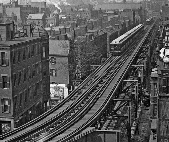
Harrison Avenue
Harrison Ave., looking north from where the Mass. Pike is today, on the old Atlantic Avenue El. If you enlarge the picture, you can see a street number, 278, on the round sign at lower right (just to the left of the letters "AR" painted on the side of the building). The buildings match the ones shown in old real estate atlases from 1902-1938. The long roof just above the train is St. James' Church.
And there seems to be some sort of backup, with the two trains following so closely. Probably both of them are stopped, waiting for a jam ahead to clear.
Tremont Street, Chinatown / Bay Village
Tremont Street looking into the South End from Chinatown, the Mass Turnpike now runs through the photo. There is the old Catholic church (can't recall it at the moment) in the background on present day Shawmut Ave. The Orange Line bent to the right and then started an decline to enter the tunnel.
Hard to recognize as such in the photo,
but I believe you're referring to the former Holy Trinity Church, the last site of German-language Masses in the Archdiocese, now the very pricey The Lucas condo building.
The Church sold it as part of its settlement fund-raising for the priest sex-abuse scandal.
They had great icons and a
They had great icons and a lovely midnight Mass.
I bet NONE of the condos have that.
I'll take a stab at City Sq
where there was a sharp (and noisy) turn before heading to North Station.
Also, one of the few times when "there's another train right behind" turns out to be true.
Once in a lifetime
"Also, one of the few times when "there's another train right behind" turns out to be true." Possibly the only time. This could be a photo of a historic occurrence!
Just a Test
In the answer, the team mentioned that this was probably a test of the Atlantic Ave. El over Harrison Ave before the line opened. So we're still waiting for an instance of this in revenue service.
Washington Street looking east from Dudley Square turnaround
I don't know the year
Harrison Ave
Based on the curve and building numbers at the bottom right (272, 270), my guess is Harrison Ave where it now crosses the Pike. That would make it the St. James Church in the background.
Edit: I agree with Charles above. Get an account and your comment will show up quicker and not make me look repetative...
This is the right answer
Saw your answer first.
Harrison Ave El
Yes, this is the Harrison Ave El looking down Harrison toward downtown from atop 5 Way Street. If you look at Plate 14 from the 1938 Atlas you can see that 272 Harrison would have been the next visible building on the right which is the address that can be seen if you enlarge the photo that the City Archives posted.
The photo would have been taken sometime between 1901 when the Harrison Ave El opened and 1917. Sometime between 1912 and 1917, 231, 233, and 235 Harrison Ave were torn down and a new, single building spanning all three lots was built, which does not appear in this particular photo.
Definitely Harrison!
It's definitely Harrison, as others have pointed out. Here's a zoomed-out shot from the archives that clearly matches:
(I *knew* I had seen this very picture before)
Awesome
I grew up in Roxbury off of Harrison Avenue and had no idea there was once an elevated line there. Thanks N.
Only a short stretch of Harrison Ave, in Chinatown
had the elevated train. In Roxbury, the el was only on Washington Street.
https://en.wikipedia.org/wiki/Atlantic_Avenue_Elevated
Motte Street is now called Herald Street.
Herald Street
Checked it out on Google Maps. Looks like Waquiot had the first closest answer even if he missed Harrison Avenue.
I used to range from Dudley square to the Cathedral of the Holy Cross (I was confirmed there) anything after that was no man's land (Nothing to do with gangs) unless I was on the Washington Street side. Back in my day that was just an industrial area.
Bonus!
Here's an 1899 view of roughly the same spot, before the elevated train was completed. The road bridge appears to be under construction:
A lot of trees got removed
In the older picture you can see trees covering the roadway in the background.
The Answer
Thanks for playing, folks!
This does indeed show Harrison Ave in May of 1901. One quirk of this photo is that the train has 10 cars. Boston never had had 10 car trains - this photo was most likely during a power test done before the line opened.