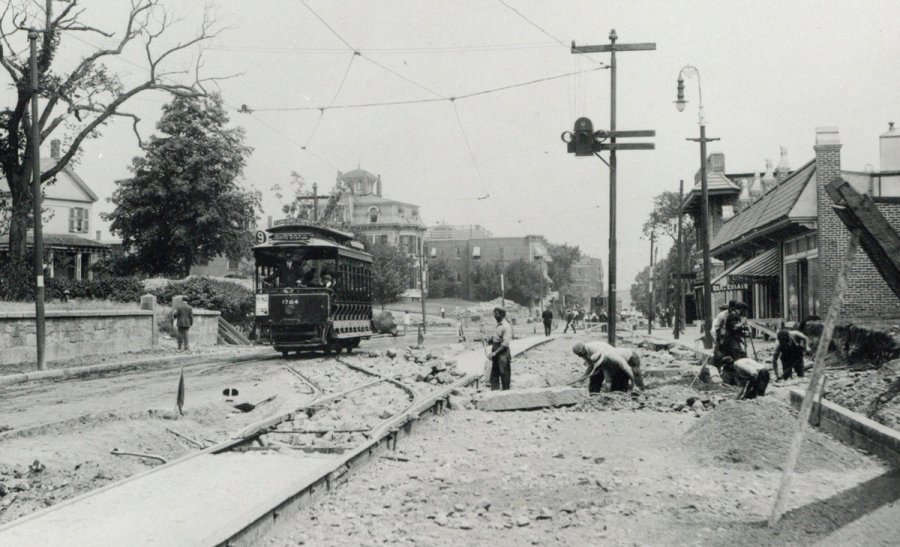
The folks at the Boston City Archives wonder if you can place this scene. See it larger.
Neighborhoods:
Topics:
Like the job UHub is doing? Consider a contribution. Thanks!
Ad:
The folks at the Boston City Archives wonder if you can place this scene. See it larger.
Like the job UHub is doing? Consider a contribution. Thanks!
Ad:Help keep Universal Hub going. If you like what we're up to and want to help out, please consider a (completely non-deductible) contribution.
Comments
Upper end of Warren Street
By Don't Panic
Wed, 02/05/2020 - 10:31am
In Roxbury with the trolley headed to Grove Hall.
house in background has same
By datdogg
Wed, 02/05/2020 - 10:49am
house in background has same roof as a house I ride by all the time with red doors. I think you are right.
Outbound car on Beacon Street
By Rob
Wed, 02/05/2020 - 11:00am
Outbound car on Beacon Street? The top signs appear to say "Coolidge Corner" and "Subway to North Station".
Don't think so
By Jethro
Wed, 02/05/2020 - 11:42am
That was my first guess, but Beacon Street wasn't that narrow any time in the Subway era. Plus, most of Beacon Street is in Brookline which would usually dq it from the mystery photo.
Ahh the good old days
By Gary C
Wed, 02/05/2020 - 11:02am
Today we get a single Orange or Red line car and have to test it for the better part of a year before people can ride it. I see here that the tracks seem to be still in a state of extreme newness and yet there's a full trolley heading down the track.
Harvard Ave., Allston
By bohhh
Wed, 02/05/2020 - 11:46am
The open car is on Harvard Ave in Allston traveling toward Comm Ave in front of what is now Blanchard’s. The intersection of Brighton Ave is in the background.
What He Said^^
By Div2Supt
Wed, 02/05/2020 - 12:05pm
To which I note that just around the corner is Wilton Street, from which A Streetcar Named The Allston/Dudley Xtown ran until September 1938.
Div 9 desk to Div 2
By bohhh
Wed, 02/05/2020 - 12:15pm
SES (Mr. Dana) - Dunks soon, kid.
A forerunner of the 66,
By Rob
Wed, 02/05/2020 - 1:23pm
A forerunner of the 66, Div2Supt?
Sort of, but the 66 is new
By Ari O
Wed, 02/05/2020 - 3:02pm
It's only been around in its current for since 1989.
Before that, it ran from Allston to Dudley, so, yes, that would have been the route. Why Allston? Because that's where the streetcar barn was. A separate route ran from Union Square Allston to Union Square in Somerville.
1989 changed all this (for the better!).
Before the change
This meant that there was no direct service from Harvard to Brookline, or even to Allston beyond Union Square.
The realignment swapped the outside of the 63 from Reservoir onto most of the 86 and created the new, longer 86, creating a route from Cleveland Circle to Brighton to Harvard, extended the 66 over the old 86 territory to connect the LMA and Brookline to Harvard (Dudley has had a connection via the 1 bus since it was combined into a single route from the 47 and 76 which met at Mass Ave Station, now Hynes). The 63 was discontinued entirely since its route was covered by the 64 and 70.
Lots more connectivity. Bang for your buck. Too bad the T has barely done any of this in the past 30 years.
I never knew that, but it
By Rob
Wed, 02/05/2020 - 7:23pm
I never knew that, but it makes sense.
Bus routes that started as legacies of street car routes - most of the Boston-Cambridge bridges didn't have rails, did they?
There wasn't a direct Brookline-Cambridge bus route originally because there hadn't been a streetcar route that did that.
There were streetcar tracks
By anon
Thu, 02/06/2020 - 9:41am
There were streetcar tracks on the Cottage Farm bridge but none on its replacement the BU bridge.
Never a Brookline-Cambridge streetcar
By Ari O
Thu, 02/06/2020 - 5:09pm
There may have been a horsecar in the West End days, but it was never electrified and anything in Lower Allston ran to Central (and would until 1989). I guess there wasn't demand to Harvard. Once BERy started to add bus routes in 1924ish, it was an early addition, running from Brighton to Harvard, and would become a Union-to-Union bus probably not long thereafter.
OMG I was gonna say that!
By Gary C
Wed, 02/05/2020 - 12:47pm
I thought I recognized the building on the right as being the old Fathers First (now Korean Bar-B-Q), but I figured that was crazy. Here's the view today.
https://goo.gl/maps/izk3G6yXknkCzUwt5
What the what
By crispino
Wed, 02/05/2020 - 1:04pm
Okay. If you are correct, then seriously, HOW did you ever figure that out? I have been living very close to here for many years and I would never have guessed that. Comparing with the modern view though the tops of the two buildings on the right match exactly. All I can say is wow.
Father's, that's a blast from
By anon
Thu, 02/06/2020 - 8:13am
Father's, that's a blast from the past. Lots of knock 'em down bars once on Harvard, blood alley !
Actually going away from us
By Charles Bahne
Wed, 02/05/2020 - 4:29pm
A close look shows that the streetcar is actually going away from us, towards Brighton Ave. and Cambridge St. The car was going "wrong rail" because of the construction on the right side of the street. You can just barely make out the trolley pole which shows that it's going away.
Since the car is double ended, they didn't bother to turn the destination sign at the end of the line. Thus it reads where the car is coming from, since it's now on the back of the car. At the end of the line, the car will reverse directions and the sign will be correct.
The route turned at Coolidge Corner and took Beacon Street into the subway.
It is heading toward us. You
By anon
Thu, 02/06/2020 - 9:18am
It is heading toward us. You can clearly see the moterman with their hand on the controller in the photo.
Did this route turn onto
By Rob
Wed, 02/05/2020 - 7:29pm
Did this route turn onto Beacon at Coolidge Corner and run to Kenmore?
Yes
By Charles Bahne
Wed, 02/05/2020 - 10:48pm
If this photo was taken in 1913, an inbound car would have turned left at Coolidge Corner onto Beacon Street, then continued straight on Beacon through what was then called Governor Square. (It was renamed Kenmore Square in 1932.) The car would have turned right from Beacon onto Mass. Ave., then left onto Boylston, and it would enter the subway adjacent to the Public Garden, between Arlington St. and Charles St.
On Oct. 3, 1914, the subway was extended from the Public Garden to Kenmore Street, which is a short cross street intersecting Comm. Ave. just east of modern-day Kenmore Square. At that time the cars ran on the surface through the square, branching onto either Comm. Ave, or Beacon St.
On Oct. 23, 1932, the subway was extended from Kenmore Street, through the new Kenmore subway station, to the current portals at Blandford St. and at St. Mary's St. At about this time the square was renamed Kenmore.
The name Governor Square came from never-realized proposals to build a governor's mansion in the square. But streetcar conductors usually announced the trolley stop to their passengers as "Kenmore", after the cross street, and so the Kenmore name stuck.
Columbia Road Uphams Corner
By anon
Wed, 02/05/2020 - 12:35pm
Columbia Road Uphams Corner
What do you base that on
By Don't Panic
Wed, 02/05/2020 - 4:02pm
What do you base that on another anon?
Thanks for playing, folks!
By Boston City Archives
Wed, 02/05/2020 - 4:17pm
Thanks for playing, folks! Those of you who guessed Harvard Ave are correct. This photo shows Harvard Ave at Brighton Ave in about 1913.
I wasn't even close.
By Don't Panic
Wed, 02/05/2020 - 11:23pm
That white house on the left looked so familiar. What did they call that room with all the windows on top of that house. I think it had something to do with ships?
A Widow's Walk
By Rob
Thu, 02/06/2020 - 12:35am
A Widow's Walk
Thank you
By Don't Panic
Thu, 02/06/2020 - 8:33am
n/t
But
By APB
Thu, 02/06/2020 - 10:02am
That looks more like a cupola. A widow's walk would have a railing.
A telescope
By Don't Panic
Thu, 02/06/2020 - 2:25pm
Probably wouldn't have fit in the Widows Walk on Warren Street. A spyglass maybe.