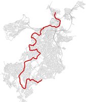
Miles Howard has created a guide to 25 miles of connected trails through Boston, from Mattapan and Hyde Park all the way up to Charlestown - complete with a variety of types of maps and step-by-step directions, along with lists of what you'll see as you hike Boston's own scenic countryside:
Connecting 14 Boston neighborhoods from the Neponset River to Bunker Hill, the Walking City Trail is a hiking path through Boston's most immersive parks, urban wilds, community gardens, and greenways.
The trail is divided into four segments that are accessible by public transportation and include frequent stopover points for food, drink, art and culture, and restrooms. You can section hike the trail, or traverse the whole thing in one day. (It's pretty much the same length as the Boston Marathon route.)
Like the job UHub is doing? Consider a contribution. Thanks!
Ad:

Comments
love love love this!
By bibliotequetres...
Sat, 06/18/2022 - 2:37pm
Thanks! I tried to piece together something like this on AllTrails, but this is much better.
Could be even longer
By Ron Newman
Sun, 06/19/2022 - 10:16pm
if you start further east than Mattapan on the Neponset River trail. (Suggestions: Finnegan Park in Port Norfolk, or Pope John Paul II Park, or Lower Mills). And now you have 15 neighborhoods, as you've added Dorchester.
Goal is for only Boston route
By HenryAlan 2.0
Mon, 06/20/2022 - 12:35pm
I'm pretty sure from his Twitter feed that the goal was for an all in Boston route. Starting in Port Norfolk, the Neponset trail ends up in Milton for a few miles before crossing at the Harvest River bridge, where the trail as he has mapped it beings.
Brookline
By Ron Newman
Mon, 06/20/2022 - 2:51pm
It looks to me like his route crosses over into Brookline at Olmsted Park (Wards Pond) and at Riverway Park.
Awesome idea!
By Bob Leponge
Mon, 06/20/2022 - 9:07am
Awesome idea!
Has anyone had any luck opening the linked maps in AllTrails? I get the thumbnail, and then when I select “view full map”, I get a blank white screen with a map scale at the bottom
Add comment