Hey, there! Log in / Register

Developer removes trees, scrub along ancient rail line in West Roxbury to make way for four single-family homes
By adamg on Tue, 03/26/2024 - 1:48pm
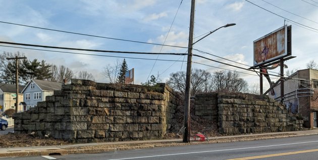
Abutment for where the bridge used to be. Behind the pole are detritus-covered stairs to the top of the embankment.
A developer is getting ready to build four single family homes off Spring Street in West Roxbury, on a former railroad right of way on which steam locomotives once paused to pick up passengers at a small train stop before thundering across a bridge over Spring Street, hauling commuters from Dedham and West Roxbury up to Park Square in Boston.
The last passenger train ran over the long gone Spring Street Bridge in 1940, but even after tearing down the bridge and selling off the land now occupied by the Star Market plaza, the railroad - eventually Penn Central - held onto the right of way until selling it in 1973 to the MBTA, which then also sat on the land, as one can see on a map of the area. Also left behind: The stone abutment on one side of Spring Street.
Finally, in 2011, the MBTA sold the half-acre stretch along Powell Street between Spring and Cass to a Powell Street resident for $325,040, according to Suffolk County Registry of Deeds records. In 2020, he sold the land, pretty much entirely covered in trees and scrub, to developer Anthony Petruziello for $1.03 million, the records show.
Last August, Petruziello got building permits from ISD to put in four houses - unusually for Boston, they required no zoning variances. In January, Petruziello sold the land and building rights for $1.45 million to another developer, Ivan Biesty, who has since put up two signs near the abutment about the project advertising "anticipated completion" this December.
The parcel's railroad history, as part of the West Roxbury Branch, dates to the 1840s, with the opening of a 5 1/2-mile Boston and Providence Railroad branch line.
The line ran between the Dedham Village train station (now the Dedham Center municipal parking lot) and the main line at Tollgate in Forest Hills, by way of Baker and Spring Streets in West Roxbury, after which it followed the route of today's Needham Line through West Roxbury and Roslindale (including what became the infamous Bussey Street Bridge in Roslindale). Unlike today's terminus at South Station, though, the line ended - and began - at a station in Park Square.
The West Roxbury Branch initially crossed Spring Street at grade - next to a small station there, along what is now Powell Street. In 1896, the state legislature passed an act requiring the New York, New Haven and Hartford, the state and the city to work together to eliminate all grade crossings on the West Roxbury Branch (and also the Dedham Branch, which connected Dedham to Boston via Readville).
The railroad hired a contractor to build a bridge across Spring Street and the city widened Spring Street from 40 to 80 feet and excavated a dip under the planned bridge so that vehicles (such as trolleys) could get under it without getting stuck.
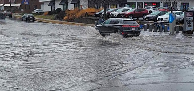
That dip remains today - and might explain why that particular stretch floods in heavy rains.
The bridge was a "span plate girder" bridge, according to a 1901 report in the Journal of the Association of Engineering Societies, which added "the abutments at Spring street were built upon broad foundations of concrete, resting directly upon quicksand."
The report said engineers had "considerable difficulty" in rebuilding Spring Street under the bridge, and that it needed twice the expected amount of "broken stone" to keep the road in place above quicksand.
The Spring Street bridge, looking towards Lagrange, in 1904; today's stone wall is on the right (From the Boston City Archives):

Ridership on the line seems to have peaked in 1900 and began declining afterwards, in part due to riders preferring the Boston Elevated Railway's extensive trolley network. In 1938, the New Haven shut Spring Street station, along with 87 other Boston-area stations as it tried to re-emerge from bankruptcy. Its bankruptcy turned into a court case, known as the 88 Stations case, that went all the way to the Supreme Court. Eventually, the state agreed to let the railroad shut a fair number of stations in exchange for continuing to operate at least some commuter-rail lines.
The railroad shut passenger service on the West Roxbury Branch for good in 1940. In 1945, the Metropolitan Transit Recess Commission called for turning the old branch into a rapid-transit line between Dedham and Forest Hills, using an overhead catenary, at a cost of roughly $4.1 million. As we know, the idea went nowhere - the same destination as a proposal in 1916 by the state Public Service Commission to convert the line into an extension of the Boston Elevated's Main Line (today's Orange Line) from Forest Hills to Dedham.
H/t John.
Neighborhoods:
Topics:
Free tagging:
Ad:
Support Universal Hub
Help keep Universal Hub going. If you like what we're up to and want to help out, please consider a (completely non-deductible) contribution.
Comments
I am an abutter. I remember
I am an abutter. I remember when I was a kid that area seemed like a wild jungle. Sad to see it go.
Ditto
Grew up on Dent Street. People see this as an eyesore, and they’re right, it is, but it’s a special kind of eyesore. Lots of teenage stories.
What will they do next, bulldoze the Grove?
I'm sad to see it go too
This could have been a nice linear park and rail trail...
But 20ish years ago, the powers that be (including an adjacent city councillor) decided to sell off instead of create a linear park for all in West Rox to enjoy... Others on this forum will have more details on the demise, but a lost opportunity for sure.
Demise?
The T offered it up parcels to abutters.
People made their back yards bigger.
These people enjoy it.
The bike path you speak about would have been about 1,500 feet long, if that. Not worth the investment considering the neighborhood, the population density, and the traffic of the area.
Money was invested elsewhere for longer community paths and they work better than this would have.
People use short bike paths too
For many years, the Somerville Community Path went only a half mile east from Davis Square, to Cedar Street. It still got heavy use. (Since last June, it now goes all the way to East Cambridge.)
Yes They Do - People Do Use Short Paths
Those paths however are at grade.
You would have had to do a lot of work for a very short path here.
The parallel streets are available for full bicycle use.
There was no "bike path" mentioned, John.
Your hatred of bikers is so strong and irrational, you see them where they don't even exist. Tsk tsk tsk.
bike path == rail trail
People often use the term "bike path" for these, even when much more of the traffic on them is pedestrians.
Hatred Of Cyclists Who Run Red Lights And Stop Signs
That's All. With summer coming, the arrogance and lawbreaking increases.
I love bike paths.
I want to ride the Assabet this spring.
Adam - Shove that Anon where the sun don't shine.
Wow
Do you know what the phrase "shove it where the sun don't shine" means? Why are you directing this aggression at Adam?
Are They Spreading Manure On The Fields?
Guess who allows Anons on the board? I'll let you think about that while the farmers take care of things around you.
A linear park that maybe ended at the Dedham line
It wasn't all that long ago that Dedham voters rejected a proposal to turn what remained of the Dedham Branch (the rail line to Readville) into a rail trail.
The T is lousy at transportation
But pretty successful as a real estate agent.
Oh god, no, no they are not
When they do sell, they sell at the wrong time:
They could have waited and gotten a million bucks, instead they sold 9 years earlier for a third the price.
And when they do have land adjacent to transit, their first inclination is to build a bus yard or a parking lot, which don't generate revenue.
The T sucks at real estate about as much as they do running trains.
The MBTA isn't legally allowed to profit from development
Sad but true!
Selling air rights is somehow allowed.
Bridge and More
The bridge over Spring Street was there well into the 1960s and maybe later. The track skirted the senior housing now in that area and then connected to the existing rail line. Currently not on display, but the West Roxbury Library used to have a wall artwork dating way-back-when showing this track and that the Star Market parking lot which was an active freight car series of sidings where boxcars and gondolas could be set out for pick up and delivery.
And as noted this was the track on which the ill-fated train passed to the Bussey Bridge and the ultimate collapse. The current bridge, now solid granite, has a commemorative plaque on the eastern (Archdale Rd.) side, often occluded by tree branches.
The current Dedham Soccer Field adjacent to Staples was at one time a wye track where trains could do a 3-point turn then return to their point of origin. Small commuter trains, often single-car Buddliner RDC units (called a DMU these days) picked up and delivered passengers well into the early 60s. I have memories of getting off a train in what would now be Staples parking lot when a very young child. Too bad that is not running today, but it is now a rail trail. That might have been a great short line from Dedham Center to Boston. The track made its way to Readville where it joined the main line for Boston.
From the current soccer field, another bridge carried the tracks over High Street, and eventually under Washington Street at a point that would now be behind Lowes. That concrete bridge where Washington Street passed over the tracks was filled-in sometime in the 1970s. The track then crossed what is now the Dedham Mall parking lot into the Belle Ave area eventually following Belle Ave and crossing Baker Street with a similar steel bridge and proceeding to the spring street crossing. A lot of that land has since been redeveloped or offered for sale to abutters along the route the tracks followed..
It used to be easy to follow with a Google Satellite aerial view but is rapidly becoming less prominent.
The old track bed used to be popular with off road dirt bikers, especially the part that went behind Ocean State Job Lot and back towards McDonalds and vicinity.
The path not taken
Of the 1945 plan, only two pieces were implemented before the 1970s: the 1950s extension of the Blue Line up the BRB&L (but just to Wonderland, not Lynn) and the 1959 Highland Branch of the Riverside Line.
There's an interesting thought experiment where the Riverside Line was replicated along what is now the Needham Line from Newton out but potentially also from Arborway out to Dedham (and potentially also out to Needham Junction). I'm somewhat surprised that this wasn't offered up as an alternative in the 1940s, since the operating yard at Arborway could have supported this service and it probably would have been cheaper to operate than extending the Main Line El since the stations would have been much easier to build (like they were on the Riverside Line).
From the historic aerials, the bridge here was taken down sometime between 1969 and 1971, and the supermarket built in between 1971 and 1978. Between there and the Dedham Mall, the right-of-way was intact until 2005 or so, when it was finally sold off in pieces for home construction (which you can see the start of on this 2007 Streetview image, and most of Belle Ave is still the tree-lined ROW at that point). Most ROWs in the region were preserved for trail or future potential transit use, but not this one.
South Station
Well, sure, because South Station didn't exist. All of the B&P's (and then New Haven's) trains went to Park Square until 1899.
The MTA, which was replaced
The MTA, which was replaced by the MBTA in 1964, never owned the right of way. The MBTA bought it, along with all of the south side commuter rail assets, from the Penn Central in 1973. The New Haven had been merged into the Penn Central in 1969.
Thanks!
I'll fix.
That explains it
I was wondering why the NIMBYs weren't already on the move to block this.
I mean, they are single
I mean, they are single family homes. Of course it didn't require variances. That's the bare minimum housing stock.
Single-family homes require variances all the time in Boston
The few that are proposed, that is, but typically because they are on lots that are smaller than current zoning allows (like our house is on a 4,500-square-foot lot on a street that is now zoned for 6,000 square feet, which is pretty common in Roslindale and West Roxbury) or too close to a lot line, or both.
I haven't looked at the zoning for this particular parcel, but it's 24,500 square feet, which basically gives you four 6,000-square-foot lots, and I bet the zoning there has a 6,000-square-foot minimum.
funny
BTW the original lot sales were to abutters only who could pay market price with the ability to sell. The market price was still lower than retail at the time or a lower price with a promise not to sell. Also at the other end of this rail bed where it abuts Baker St. was given a building permit with no hearing. It was undersized and needed 4 other variances after the neighbors threatened to sue.
Also all those houses on Belle Ave are not up to code
All who you know… still
Rail trail
There was also a bridge at the end of that lot and one over baker street. Baker street one was torn down sometime in the 1940’s. the one at Summer Street was taken down after the T sold the land in their neighborhood program. And yes, you could walk the length of the old rail bed from Spring Street to the Dedham mall all the way until the 1990’s. Did It more than a few times. There was discussion of a bike walking path when the T finally sold. Of course there was vehement opposition. There is a large rock outcropping halfway between Spring and Baker as well as it was quite overgrown at that time. It was the favorite place for CM kids to smoke at the time. If you walked it back then you could still find coal on the side of the rail bed.
My only question is are they going to bring it down to street level, it’s quite elevated. Another piece of history gone….
And if they don't...
And if they don't drop it to the level of Spring Street who becomes responsible for the maintenance of the granite retaining wall. Lots of questions there.
Boston and Providence Railroad Station in Park Square
The center and right portion of the image is the Boston and Providence Railroad Station
I've been expecting this article...
I've been expecting this article since last week when I saw the shorn embankment. I didn't expect the article to be this informative, though. It's weird that you don't charge a fee for the work you do on this site, it definitely qualifies as worthwhile local journalism.
Is no one else..
Is no one else going to mention the quicksand? Quicksand in West Roxbury. I thought the rumors of quicksand in the swamp near Houghton's Pond was a suburban legend. Now I find out there was quicksand even closer than the Great Blue Hills for real. I'm in shock!
4x1? Why not 3x2?
I get it, it's West Roxbury. But they couldn't have even done three 2-family homes? Hell, I'm surprised Boston didn't figure out how to fit a biolab in that space.
Always interesting to hear
Always interesting to hear the history of these old stone walls that appear random today. Even a google satellite view now, you can tell there used to be an old rail right of way there. As others have commented, too bad it was not preserved in some way. Obviously rail-trails are very popular but also I tend to think of what if it could still be used as light rail?
Anyway, cool back story and loved that old photo of the bridge still up. Anyone here ever rode that line when it was operational? (or knew people that have?)