Hey, there! Log in / Register

Probably wasn't right next to the G & G
By adamg on Mon, 03/30/2015 - 11:01am
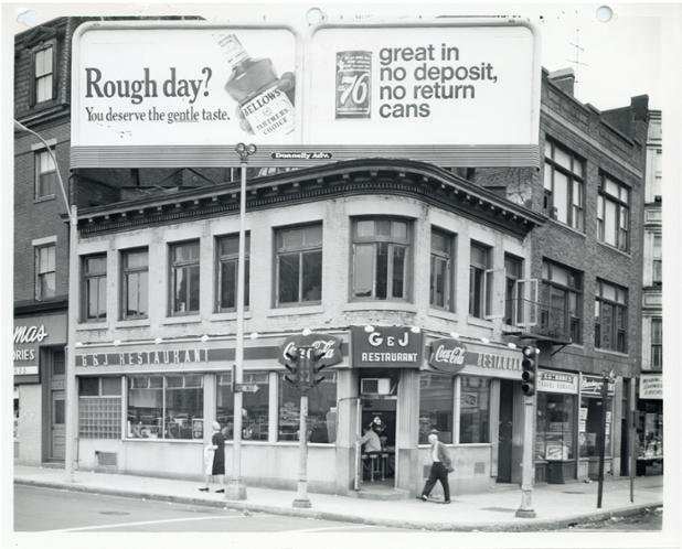
The folks at the Boston City Archives wonder if you can place this photo. See it larger.
Neighborhoods:
Ad:
Support Universal Hub
Help keep Universal Hub going. If you like what we're up to and want to help out, please consider a (completely non-deductible) contribution.
Comments
Boylston street
Boylston street
Hmm
Looks like where New York Pizza is on Mass Ave.. or whatever that pizza place is on the corner of Tremont and Mass Ave.
Just a guess.
Update: Nope, I'm wrong. Totally difference building. Helps if I look before I post. Oh well!
635 Huntington?
used to be a soda fountain there...
Sparrs?
Looks VERY much like the old Sparrs diner on the corner of Huntington and Longwood Ave.
Yep that's it!
Here's how it looks today...
https://goo.gl/maps/UVwdP
Are you sure?
What's the billboard pointed at? Seems like there should be a bigger road nearby to see it than what's in Longwood.
There Are Similarities, But Too Many Differences
Maybe.....
I still think it's Sparr's, but there IS a One Way sign in front in the old picture that would be pointing the wrong way if that is Huntington Ave.
Also, John Costello's comments below about the internal layout of the counter are spot on...but who's to say they they didn't renovate when it became Sparrs.
I'm wavering, but not ready to give up yet.
Sparr's is (was) pretty old.
It may have been there in the 1950s, I'm told it was there in the early 1960's anyway.
Theater District
I'll go with where Wendy's was on the corner of Tremont and Stuart.
Sparr's was the first thing I thought too.
Not Sparr's
The building to the right is completely different to be Sparr's. Also, the lunch counter in Sparr's was off to the left, not right when you walk in the door like is shown here. You walked into Sparr's and the floor rose with the Cliff Notes on the right, the candy counter in the middle, and the food counter on the left.
This is in Bay Village, somewhere on Tremont Street before it was reconfigured near the Church of All Nations / Elliott Norton Park. The travel agency on the right is still listed as being in that housing development bounded by Tremont, Marginal, and Washington. It might be where Beacon Hill Skate is now or at least in front of Beacon Hill Skate with the widening of Tremont.
Urban renewal took this building at some point. The address should be in the mid-300's of Tremont and the picture looks about 1962-1966.
Bay Village seems very right
If you look at the cleaner on the far right, it says "Broadway" cleaner... prior to urban renewal, Broadway from Southie actually extended all the way there. Today there is just a smidgen of Broadway left, but it it still there in Bay Village.
It's not Sparr's (I miss
It's not Sparr's (I miss Sparrs!)
If you look in the photo there are a couple things of note. The doorway on the left has 149 on it. 149 Huntington Ave is down in Copley Square area. It looks to me if there is an address of 328 or something like that above the door on the corner and if you google Kutrubes Travel it still exists at 328 Tremont Street which is in Bay Village.
Alright I'm convinced
The fact that the travel agent is still at the same location (but in a new building) is solid proof to me.
City Directory
You're right. Here's a Boston City Directory from 1956. No C&J Restaurant in it (they probably opened after '56), but Broadway Cleaners (right side of photo) is in there, and listed as 309 Tremont St:
http://www.donslist.net/PGHLookups/Boston1956M.htm (see page 365)
This intersection has since been completely redeveloped, and now looks nothing like the photo. Now it's where the bend in Charles St. is (Eliot Norton Park), but back then, it would have been the intersection of Broadway and Tremont.
When you see it larger...
... there is one of those plaques on a pole with a small flag dedicating the corner/intersection to a veteran. Nothing like that at the Huntington Ave site others have suggested & I don't think that's the type of thing the city removes.
Broadway and Tremont
Broadway and Tremont
G&J was #318 Tremont and Kutrubes Travel Services (in the photo next door) was #320 Tremont (1964 Boston street directory)
Kutrubes is still in business at 328 Tremont. The area is completely unrecognizable from the photo now.
help for the youngsters?
1) what was 76 soda?
2) was there serious "anti-deposit" feelings when the law took effect?
this picture
is older than 1983... so I doubt that.
Bottle law was passed in 1983.
No deposit, no return
While few states were mandating returnable containers, many stores marketed products in returnable containers. That's because the cost of the container itself was still considerable.
My husband talks about A&P having returnable bottles for soft drinks.
This makes sense if you think about the kind of sturdy glass soda bottles and milk bottles used at the time.
It does help date the picture: while aluminum cans entered the market in 1957, easy-open aluminum can ends for beverage packaging debuted in 1962. That puts us right in the range of dates that John Costello states, above.
http://en.wikipedia.org/wiki/Aluminum_can
As a kid in the late 1960s
I vividly remember soda companies strongly pitching "No Deposit No Return" in both their advertising and on the "by the case" and bulk packaging for the bottles/cans.
Castle Square...
...corner of Tremont and (no long extant section of) Broadway.
This is the area where the Pleasant Street incline came out of the subway, until the entire area was substantially remade in the 70s.
As others have pointed out, Kutrubes Travel still exists at 328B Tremont -- can't be a coincidence. But the building it currently occupies is new. In addition, Tremont Street today is on an entirely new alignment here, and almost every inch of Broadway west of the channel has been wiped away.
One can barely make out the number of the restaurant as 318. Zooming in on a Bromley map from 1938 reveals a building with a curved corner at #318 Tremont. http://www.wardmaps.com/viewasset.php?aid=4826
Throw in Broadway Cleaners and it all fits. The only mystery is narrowing down the date. Fonts on the billboards speak late 60's to early 70s.
Correction: not Castle Square as such
but Castle Square area. (I was just going by what Ward Maps called the detail map of that area. I don't know exactly where Castle Square was/is.)
Castle Square...
Castle Square was on the other side of the railroad tracks (and now the other side of the Mass. Pike), at the corner of Arlington, Tremont, and Chandler Streets, near the Animal Rescue League today.
Thanks for the info
The 1938 Bromley map itself calls that intersection "Arlington Square", but Ward Maps lists that map page as "Castle Square"
The 1912 Bromely map calls it "Castle Square" and what we now call Arlington Street was Ferdinand Street. Stands to reason they renamed it Arlington Square at the same time they renamed the street.
You're definitely right.
You're definitely right. Corner of Tremont and Broadway. You can barely make out #149 Broadway to the left of G & J Restaurants, which perfectly corresponds to the map.
Different angle on the same corner:
VERY different angle. Look at the upper right corner of the photo. fourth story Mansard roof: check. Billboard at angle: check.
https://pbs.twimg.com/media/Bl53BjKIAAAmxL5.jpg
Poor man's "7 and 7"?
Poor man's "7 and 7"? (Seagram's 7 and 7-Up)...
Bellows and 76.
Was Bay Village
G & J was where WMEX employees went for lunch when the studios were at 111 Broadway.
The Answer!
Thanks for playing, folks! This is 318 Tremont Street on September 15, 1962