The follks at the Boston City Archives wonder if you can place this scene. See it larger.
Neighborhoods:
Topics:
Like the job UHub is doing? Consider a contribution. Thanks!
Ad:
The follks at the Boston City Archives wonder if you can place this scene. See it larger.
Like the job UHub is doing? Consider a contribution. Thanks!
Ad:Help keep Universal Hub going. If you like what we're up to and want to help out, please consider a (completely non-deductible) contribution.
Copyright by Adam Gaffin and by content posters.
Advertise | About Universal Hub | Contact | Privacy
Comments
Commercial point?
By Lmo
Tue, 12/20/2016 - 12:33pm
Commercial point?
Eastie, circa 1890.
By anon
Tue, 12/20/2016 - 12:51pm
Eastie, circa 1890.
I'm gonna guess Columbia
By Murphquake
Tue, 12/20/2016 - 1:00pm
I'm gonna guess Columbia point area, Savin Hill is in the background.
Not really sure tho
looks like it
By BoredatWork
Tue, 12/20/2016 - 1:13pm
picture taken from what is now the BC high football field area ? unless the white on the right side of that walkway is water ... unless that side of water dried up ? .. im like %65 sure
I think the water on the r is
By Lmo
Tue, 12/20/2016 - 1:20pm
I think the water on the r is where the Blvd and the football fields are now.
Is the foreground the DYC (Dorchester Yacht Club)?
By anon
Tue, 12/20/2016 - 1:32pm
Is the foreground the DYC (Dorchester Yacht Club)?
Granite Ave?
By SwirlyGrrl
Tue, 12/20/2016 - 1:38pm
Where it crosses the Neponset? The buildings are different but the terrain looks right.
Might be Mill Street, now Victory Road
By John Costello
Tue, 12/20/2016 - 7:44pm
Clam Point looking towards Popes Hill. The inlet on the left would be the Victory Road baseball fields now and midground riight would be the Armory now. Just a guess.
Shays Beach/ aka Shades beach
By ZD
Wed, 12/21/2016 - 3:48pm
Shays Beach/ aka Shades beach Orient Heights
Isnt it time for "thanks for playing"?
By anon
Wed, 12/21/2016 - 4:27pm
And the answer?This one is intriguing.
Answer?
By SBer
Wed, 12/21/2016 - 4:18pm
Has Boston Archives provided an answer? Usually they respond same day.
My guess
By Waquiot
Wed, 12/21/2016 - 7:46pm
They had their Christmas party yesterday and are still hung over. Archivists party hard.
That was one hell of a party
By anon
Thu, 12/22/2016 - 9:15am
It's 9:15 am on Thursday morning and we still dont know the answer.
Sorry folks, the archivist
By Boston City Archives
Thu, 12/22/2016 - 2:05pm
Sorry folks, the archivist took a day off yesterday, and forgot to post the answer before leaving work on Tuesday night!
Going to guess Clam Point looking toward Savin Hill....
By Stephmcc
Wed, 12/21/2016 - 5:52pm
... How early was there gas storage located there? The point of view seems well elevated above the rooftops - the kind of perspective you'd get from atop a gas tank. Maybe a predecessor to the one sitting there today?
Savin Hill in the background
By anon
Wed, 12/21/2016 - 7:48pm
Bridge is where Savin Hill Ave now goes over Expressway.
View is from Savin Hill Ave closer to Dot ave.
Water is filled in for T and Xway.
The answer
By adamg
Thu, 12/22/2016 - 9:32am
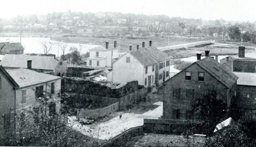
From the Archives: Preston Street in Dorchester from "gasholders", ca 1888.
Some more information
By anon
Thu, 12/22/2016 - 10:09am
Here is a map from 1888 on the Library of Congress website. (Be patient, It takes a while to load).
https://www.loc.gov/resource/g3764b.ct005938/
Preston St no longer exists and is now the Expressway, and the gas tank. The Boston Archives image is looking north. The bridge across the water is for the railroad, with Savin Hill located to the right of the bridge (mostly not shown in the picture ) Meetinghouse Hill the hill shown to the left of the RR bridge.
Also the reference to "gasholders" is mentioned on the Dorchester Historical Society website. (Norton currently shows this website as dangerous, perhaps it's infected with a virus or malware). I've used it without problems before.So here is a cache link to some information about gasholders and the site in question
http://webcache.googleusercontent.com/search?q=cac...
For Some Perspective
By John Costello
Thu, 12/22/2016 - 10:13am
The houses right in front of you are now under the Expressway. They were obliterated by Boston Gas in the late 1800's. The water part was called Barque Warwick Cove.
The water to the right is now Expressway Toyota and just beyond that is now Morrissey Blvd.
The street in the middle; the causeway is now Victory Road. The water to the left now has CVS and the former Bradlees, now National Wholesale on it. The first bit of land to the rear of the water on the left is now the Red Line to Braintree and that is Pope's Hill to the rear.
The photo was taken from what is labeled pink as Gas Holder on the attached.
http://www.dorchesteratheneum.org/page.php?id=2498
Or?
By anon
Thu, 12/22/2016 - 10:26am
Hmmm. You see it as looking south and the hill is Pope's Hill. I see it as looking north with the hill in question being Meetinghouse Hill.
I just posted this on a separate post, from 1888 . It takes a while to load.
https://www.loc.gov/resource/g3764b.ct005938/
If anyone from the Boston Archives is reading this, do you have any further information?
There was no bridge over Savin Hill Cove until the 1920's
By John Costello
Thu, 12/22/2016 - 12:00pm
You are looking west, trust me.
There was no bridge until Old Colony Parkway, now Morrissey Boulevard was built over that part of Dorchester Bay.
If it was Meetinghouse Hill, you would be able to see the First Church in Dorchester (1805 version of which the current 1890's church is a copy) and probably St. Peter's. Also, if you were looking towards Meetinghouse Hill, you would easily see both Meetinghouse Hill and Jones Hill.
I know the crest of Pope's Hill, I go by it nearly everyday from the train or the expressway.
.... "By the gas yard wall" as they old lyric goes
By Stephmcc
Thu, 12/22/2016 - 11:10am
Thanks for the map John. Now it all makes sense. It seems I was correct in thinking that the photo was taken from atop a gas tank and your map shows that we're looking down Plymouth St. You can clearly see the stacked logs in the "Wood Yd" and, beyond that, buildings in the "Coal Yard" as well. I suppose I shouldn't be surprised by time's transformation of the vista but fascinating nonetheless. Thanks again!
Dreamed a dream by the old...
By Lmo
Thu, 12/22/2016 - 12:27pm
Dreamed a dream by the old..... marsh?!?
The Answer
By Boston City Archives
Thu, 12/22/2016 - 2:04pm
Thanks for playing, folks! This shows Preston St in Dorchester and was taken from the "gasholders", in about 1888
Add comment