
It's 5:30 p.m. on a weekday on 95 south - where are all the cars?
By now, the story of why I-95 doesn't go straight through Boston is well known: Bands of determined residents helped convinced Gov. Francis Sargent we really didn't need a couple of superhighways rammed through Boston, Brookline, Cambridge and Somerville - I-95 and the I-695 "inner belt."
But before Sargent cancelled plans for the Southwest Expressway for good in 1972, the state had already taken hundreds of acres of land, demolished hundreds of houses and businesses - and actually begun work on the roads.
Today, 50 years later, you can still see evidence of the roads that never were, from the stub ramp off I-93 in Somerville to empty lots along Columbus Avenue. And you can, if you're out for a hike, even walk on parts of the I-95 that never was.
The other day, I set out for the northern half of the cloverleaf where Rte. 128 and I-95 were going to meet in Canton.
I took what might be the longest way to walk there: Drove over the Neponset at the Hyde Park/Milton line, veered right and pulled into the parking lot for the canoe launch. I followed the path sign to Fowl Meadow and then started walking. And kept walking. And walking. Until I could hear and then see the traffic on 128 (note: There's currently a fallen tree across the path near the end - you'll either need to carefully make through the large bramble or have thought to bring hip waders so you can walk through the swamp on either side of the path).
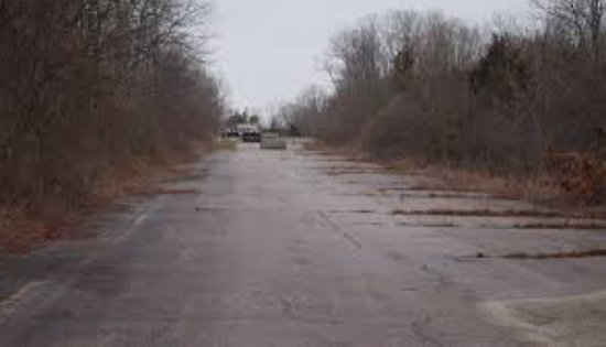
The path ends in a short paved section; follow that up, and you're at the exit ramp where traffic from 95 south would've gotten onto 128 north:

Turn to your left and you'll see the MassDOT storage shed that sits a bit further north on that ramp:

There's a path around the right of the shed that gets you back onto the ramp, which ends a few hundred feet into the woods with some dumped asphalt and logs:


At the dumped asphalt, you can get onto the main interstate, or what's left of it, heading south. It ends just past a collection of Jersey barriers - and just before 128:

If you look at a satellite view of the cloverleaf (see below), it looks like it'd be easy to get from the southbound to the northbound side - just walk through a bit of woods. What the view doesn't show, though, is the 15 or 20 foot drop in between. The cloverleaf was built in a large marshland - and had to be raised well above it. In fact, one of the objections to the highway was that it would have destroyed Fowl Meadow, which today is largely a wildlife preserve (on the way back, I saw a couple of deer). But the northbound lanes seemed equally quiet:

The ramp from 128 north to I-95 south:

Oh, look, a sign the state had to take down when it decided Rte. 1 no longer went up along the VFW Parkway (today, the exit towards that road is marked "To 1A"):

If you go, make sure the GPS on your phone is turned on - it's fun to see where you are and figure out which direction you'd be heading if the cloverleaf were actually in operation:
If you want to complete the undone I-95 circuit, head up to Revere for the northern part of the highway that never was.
Like the job UHub is doing? Consider a contribution. Thanks!
Ad:
Comments
Intrepid shoe-leather
By Rob
Sat, 04/14/2018 - 2:42pm
Intrepid shoe-leather reporting, old chum, but - ...
...doing that much photography around unused road, barriers, and brush, you forgot to bring along an important prop!
[img]https://www.modeltoycars.com/for_sale/pc/catalog/c...
Next time, come to Saugus
By Ron Newman
Sat, 04/14/2018 - 3:29pm
Some of the partially-built I-95 is in Revere but a lot more is in Saugus. Between Ballard and Bristow streets, there is a newly built stone-dust path. South of there, the path is unimproved dirt. Eventually you'll reach a drone airport.
Used to work near there a very long time ago
By merlinmurph
Sun, 04/15/2018 - 8:58am
In the 80's, I worked very near the train station and we had a running route that went down into this area. It certainly was an eerie area to run in. No traffic, though. ;-)
SHHHHHHHHH, Adam!
By chaosjake
Sun, 04/15/2018 - 1:56pm
You're going to blow up one of my favorite trail running spots! I chased a good sized coyote down the trail for a while on Friday.
Seriously, though, if you had gone just a little further up the southbound side, to where it ends in the woods, you could have crossed to the northbound lanes without clambering into the gully between them. Then heading south on the northbound side, just a few steps before the guardrail for the active highway ramp, a trail would have veered off to your left that would take you to Little Blue Hill and the park and ride area on 138 near the Dunkin Donuts.
Good to know!
By adamg
Sun, 04/15/2018 - 3:40pm
For my next visit down there (also good to know about the trail on the other side of 128).
Based on the impressions in the mud on the trail, somebody on a horse had ridden down it fairly recently.
Information in Southwest Corridor Park
By lbb
Mon, 04/16/2018 - 9:58am
There are a number of informational displays along Southwest Corridor Park, which is on land that was taken for the project, about what the neighborhoods used to look like and how the project was stopped.
Lots of families forced out
By anon
Wed, 11/25/2020 - 5:23pm
Lots of families forced out of their homes unwillingly. Thank goodness for the families who stood up and said no. We have the orange line now and a bike/pedestrian way directly in town. Just look at how the expressway ruined the boston waterfront as well as the whole waterfront of Dorchester - the downtown got the new greenway but the dorchester waterfront is ruined. Approximately 7 miles if prime waterfront real estate.
Just say yes to public transit over highways
Pages
Add comment