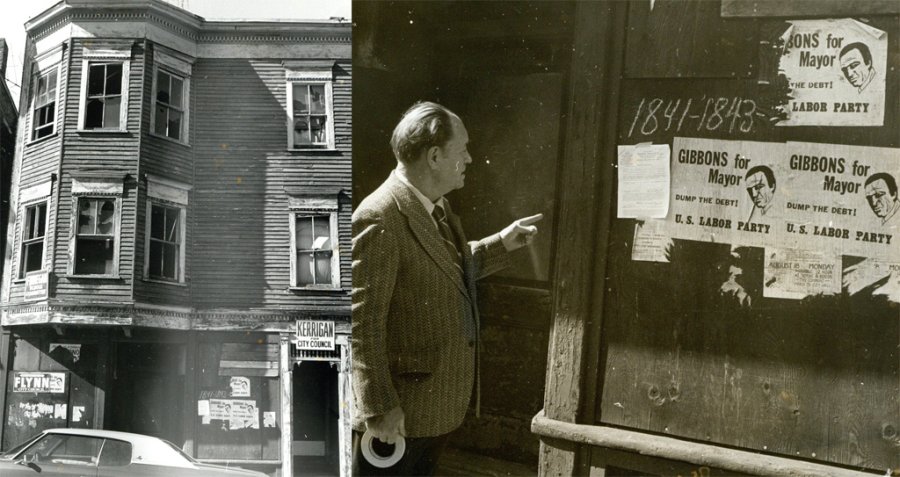
The folks at the Boston City Archives wonder if you can place this dilapidated old building. See it larger.
Neighborhoods:
Topics:
Like the job UHub is doing? Consider a contribution. Thanks!
Ad:
The folks at the Boston City Archives wonder if you can place this dilapidated old building. See it larger.
Like the job UHub is doing? Consider a contribution. Thanks!
Ad:Help keep Universal Hub going. If you like what we're up to and want to help out, please consider a (completely non-deductible) contribution.
Copyright by Adam Gaffin and by content posters.
Advertise | About Universal Hub | Contact | Privacy
Comments
1841 Columbus
By capecoddah
Tue, 06/18/2019 - 11:10am
On google maps, there is a Marty for mayor sign on the newer building there.
It's in Southie somewhere.
By MattyC
Tue, 06/18/2019 - 11:47am
It's in Southie somewhere. There's a Kerrigan for City Council sign on the wall, and he was from South Boston and served as city councilor in 15 non-consecutive terms from 1933-1973.
Link: https://en.wikipedia.org/wiki/John_E._Kerrigan
I know this building from riding around the neighborhood, but it's not coming to me where exactly it is. Best guess is City Point, on W 4th, somewhere between L and O.
Redo
By capecoddah
Tue, 06/18/2019 - 11:57am
Dorchester Ave. The building is still there.
https://www.google.com/maps/@42.2879725,-71.0637164,3a,75y,253.06h,91.22t/data=!3m6!1e1!3m4!1ssH2Ctcb0w4mZ7wlkFC_WYg!2e0!7i16384!8i8192
No the GMaps building is
By MattyC
Tue, 06/18/2019 - 12:08pm
No the GMaps building is brick, and the bow windows in the archive photo don't have fully encased trim panels.
Empty Lot Next Door?
By Jethro
Tue, 06/18/2019 - 3:00pm
The address on the building in the picure is 1841-1843. The exising building on GMaps is 1845-1847.
Big Bad Wolf
By capecoddah
Wed, 06/19/2019 - 12:01am
That is easy to explain.
1837-1839 was made out of straw. Empty lot.
1841-1843 was made of wood. Empty lot.
1845-1847 is made out of brick and still stands.
Seriously though. The windows and doors match perfect as for location. Too much of a coincidence to have a matching building (in brick) across town only two house numbers apart on such a high numbered street.
Found the big bad wolf
By eekanotloggedin
Wed, 06/19/2019 - 11:56am
It’s not the same building.
By Homer Bedloe
Tue, 06/18/2019 - 5:59pm
It’s not the same building. Original building is wood frame, your building is masonry.
Agreed.
By capecoddah
Wed, 06/19/2019 - 12:03am
Since the answer is Dot Ave, it makes me wonder why they built a brick one exactly like the wood one next door.
Kerrigan would have been at-large
By Waquiot
Tue, 06/18/2019 - 12:56pm
As the entire council was elected at-large from 1949 until 1983 (or 81.)
I'm going with Capecoddah. Tremont Street. And the year was 1975.
After 75..
By anon
Tue, 06/18/2019 - 1:29pm
Gibbons ran for Mayor in 75, but Flynn didn't run for City Council until 78..
Different John Kerrigan
By Jethro
Tue, 06/18/2019 - 3:06pm
Given that Gibbons ran for mayor in '75, the Kerrigan sign is likely for John J. Kerrigan
Bad guess
By anon
Tue, 06/18/2019 - 8:31pm
West Fourth Street is in the lower end. East Fourth is between L and M.
Typos happen...
By MattyC
Wed, 06/19/2019 - 10:12am
Typos happen...
that dilapidated triple decker?
By bostnkid
Tue, 06/18/2019 - 1:39pm
looks like a million bucks to me. at least a million.
1975 or after
By mv
Tue, 06/18/2019 - 12:34pm
Gibbons ran in '75 https://en.wikipedia.org/wiki/1975_Boston_mayoral_...
Dorchester
By The Fox 915
Tue, 06/18/2019 - 1:52pm
1841-43 Dorchester Ave Dorchester
1975
By Charles Bahne
Tue, 06/18/2019 - 4:33pm
August 18 was a Monday in 1975, also in 1969 and 1980. '75 seems most likely.
The "street number" 1841-1843 is a problem. There are only a few streets in the City of Boston that have numbers going up to the 1800s. I checked most of them on old real estate atlases, and none had any wooden buildings resembling this one at that address. Streets I ruled out were Beacon Street (Brighton, south of the reservoir), Centre Street (West Roxbury), Columbia Road (Southie), Columbus Avenue (near Egleston Sq.), Commonwealth Avenue (Brighton), Dorchester Avenue, Hyde Park Avenue, River Street (Hyde Park), Soldiers Field Road, and V.F.W. Parkway. [Blue Hill Avenue and Tremont Street only go up to the 1600s.]
Surprisingly, the best match seems to be Washington Street in the South End, between Camden and Lenox, which actually did have a wooden building at 1843. But the old atlases say that it was just a 2-story building, and they don't show any bay windows. On the other hand, the general state of decrepitude would match that location; so many buildings there had been abandoned in that era, assuming that the Inner Belt was coming their way.
Is there any chance that the number may refer to something other than the address?
Gibbons was a Lyndon LaRouche cult member!
By Ron Newman
Wed, 06/19/2019 - 7:00am
https://en.wikipedia.org/wiki/U.S._Labor_Party
https://en.wikipedia.org/wiki/1975_Boston_mayoral_... - he got a whopping 1002 votes in the preliminary election
Archives photo
By None Such
Wed, 06/19/2019 - 2:05pm
Since no one has suggested this yet, I thought it looked like the old Carroll building on the corner of Lamartine and Paul Gore Streets in Jamaica Plain, before it was renovated into the Nate Smith House.
The answer
By adamg
Wed, 06/19/2019 - 7:50pm