By adamg on Wed., 7/24/2019 - 10:36 am 


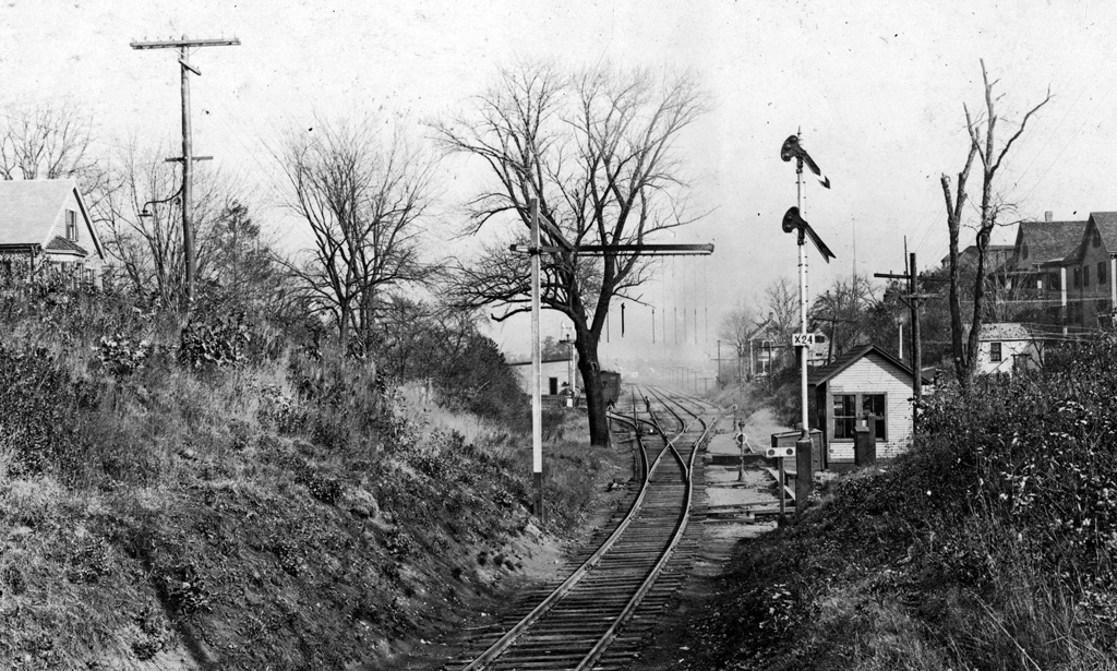
The folks at the Boston City Archives posted this photo, taken from a bridge over some train tracks and wonder if you can place it. See it larger.
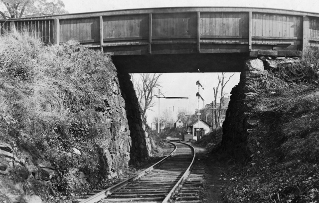
And here's the bridge the photo was taken from:

Topics:
Neighborhoods:
Like the job UHub is doing? Consider a contribution. Thanks!
Ad:
Comments
The terrain looks a little
By Scratchie
Wed, 07/24/2019 - 11:17am
The terrain looks a little like Brighton (e.g. Brooks Street area) but that's a total guess.
Single track, though
By Ron Newman
Wed, 07/24/2019 - 11:33am
Was the Boston & Albany mainline (now the Worcester commuter rail line) ever less than two tracks wide? Before the Pike, it was wider than it is today. So I say no to Brighton.
B&A
By Charles Bahne
Wed, 07/24/2019 - 1:36pm
The Boston & Worcester may have been single track when it was first built in 1834; but it was double track by 1874. And it was a 4-track line when the Boston & Albany grade-separated it in the 1880s.
readville
By bostnkid
Wed, 07/24/2019 - 11:24am
hyde park?
My thought too
By Gary
Wed, 07/24/2019 - 11:37am
Sure looks like Readville where the commuter rail lines cross now
Is that on the Mattapan "High
By bibliotequetres...
Wed, 07/24/2019 - 11:37am
Is that on the Mattapan "High Speed" rail, somewhere between Ashmont & Milton?
Mattapan Line has two tracks
By Ron Newman
Wed, 07/24/2019 - 1:30pm
So, no.
except
By anon
Wed, 07/24/2019 - 6:34pm
she was right.
It goes from a single track
By ScottB
Wed, 07/24/2019 - 11:40am
to at least four tracks in the distance, so I'd presume this is at the entrance to a train yard.
Fenway stop
By Mr. Jeff
Wed, 07/24/2019 - 11:53am
Is this the Fenway stop?
There was no Fenway stop on the original railroad line
By Ron Newman
Wed, 07/24/2019 - 12:14pm
The MTA added that station after converting it to what we now call a Green Line branch in 1959. Also that's flat land, not surrounded by wood-frame houses on top of bluffs.
Are the hanging chains there
By anon
Wed, 07/24/2019 - 12:56pm
Are the hanging chains there so a train doesn't get storrowed by the bridge?
That's called a Telltale
By Stevil
Wed, 07/24/2019 - 4:41pm
In the "olden" days men had to wander from car to car on top of the car to turn the brake wheels to lock up the train. If someone was up there working while the train was in motion (they did that back in the day), they might have their back to the bridge or not be looking up. Those are actually probably ropes, not chains. if the rope hit the guy working, he knew he had a second or two to duck down or HE would get Storrowed by the bridge. Early safety feature before they came to their senses and determined it's kind of stupid to have people wandering the tops of trains while they were in motion. Guessing modern braking systems helped speed that along.
I still waiting for that
By anon
Wed, 07/24/2019 - 2:53pm
I still waiting for that train.
It will probably come before
By my 2 cents
Thu, 07/25/2019 - 1:51pm
It will probably come before the Red Line.
Thanks for playing, folks!
By Boston City Archives
Wed, 07/24/2019 - 4:11pm
Thanks for playing, folks! This is the Medway Street Bridge, over the Mattapan High Speed Line, on November 5, 1923
Map Junction
By Jethro
Wed, 07/24/2019 - 4:52pm
The location can be seen in the 1918 Dorchester Bromley Atlas on MapJunction. I think this link goes right there https://mapjunction.com/index.html?id=/12828
Of the atlases available on MapJunction, the 1904 seems to be too early for this little freight yard, and the 1933 is post trolley conversion.
When was the Mattapan Line converted to double track?
By Ron Newman
Thu, 07/25/2019 - 12:13am
In this photo there is only one track, unlike today.
1929 I think?
By Cute Username
Thu, 07/25/2019 - 9:55am
I'm not sure, but that right of way didn't actually become the Mattapan Line per se until 1929, and that would make sense as the turning point. That's when they converted it to "high-speed" trolleys, and it's really difficult to do rapid transit without two tracks. And conveniently Wikipedia has an article about the previous Dorchester and Milton Branch that has a picture from 1928 where the track is still single-tracked at Central Avenue so that narrows things down quite a bit.
Add comment