Hey, there! Log in / Register

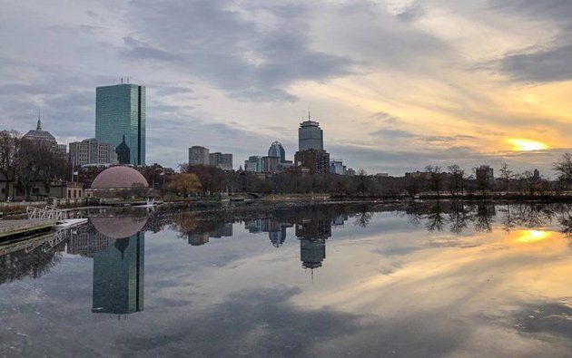
Reflecting on the sunset
By adamg on Fri, 12/27/2019 - 6:09pm
Ad:
Support Universal Hub
Help keep Universal Hub going. If you like what we're up to and want to help out, please consider a (completely non-deductible) contribution.
Comments
It's a very pretty city
Nice pic
Yes -- IT Is!
Olmstead and his company [sons] and others did a most amazing job of reworking the Charles from a tidal mostly salty creek meandering through mud flats [low tide] which was also a Tidal Pond with muddy shores [high tide]*1 into the Basin we know and love today.*2
However -- its not just their work we should celebrate -- we have to thank the visionary [or not so visionary architects and their clients] who gave us the sources for these great reflections which only add to our visual pleasure.
In particular we need to thank -- Henry Cobb for the building formerly known as John Hancock Tower, and even Charles Luckman for the Pru and don’t forget Henry Cobb again for the 1 Dalton
*1
Both before the filling of the Back Bay and also after the filling
*2
Note: I don't need to be corrected about the timing I know the dam creating Science Park for the MOS was in 1910 -- that's why the sons and others are mentioned -- although it was Olmstead's vision that was key
That reminds me ...
I need to get working on a story about how the Charles River Basin came to be (like how you can still see the old seawalls that used to line the Boston side of the river back when it was more of a tidal estuary).
I seem to recall Olmstead wasn't really that concerned with the Charles River - his main issue was to flush all the sewage from Stony Brook that was winding up in his newly done Fens segment of the Emerald Necklace into the Charles, where the tidal flow would take it out to sea, or at least away from the Fens, and so he created a fairly elaborate system to keep the Fens a sort of permanently flooded area (because the sewage only stinks when it's uncovered), via something called Charlesgate that would basically control water flowing into the Charles.
Except it didn't work for very long, because construction of the first Charles River dam changed the Charles from a tidal estuary into a large lake and ruined his tidal-flow solution, so city engineers had to go back and essentially bypass Charlesgate with a new sewage pipe to take all the stuff from the Fens and move it to the other side of the dam, so it could take advantage of outgoing tides (and as we know, that ultimately didn't work so well, either). And that's why there's that ornate, falling apart building that looks like a giant comfort station as you head down from the Fenway onto Storrow Drive - it's where Stony Brook crap was transferred to the new sewer main.
Olmsted & Charles River with some help
Technically Olmsted's work didn't include what today we commonly refer to as the "Esplanade" as in Hatch Shell area
However he did work on the strip of land along the Boston bank of the Charles -- specifically Olmsted's work on the Charles itself involved two projects: Charlesbank [near the MOS] and the Charlesgate/Upper Park [extending from the Harvard Bridge west to the Boston
University Bridge].
the following excerpts are taken from a Boston Landmarks Commission
Environment Department
City of Boston study document:
Boston?
mostly ugly and charmless, certainly WR, Roslindale and Hyde Park are. I guess the Back Bay is quaint enough. To each their own of course but I can't imagine why you'd come here as a tourist.
To each his own, I guess
I mean, no, I wouldn't recommend a tourist visiting Roslindale, Hyde Park or West Roxbury, either, not because they're charmless, but because there isn't all that much touristy to see, beyond the Arboretum and Stony Brook Reservation (although a Civil War buff might be able to find enough in Hyde Park to warrant a visit; ditto for a train buff).
I'm at a loss
to tell visitors what to go see in Boston anywhere. The Trinity Church and the Constitution are pretty much the only historical interesting things in this city that aren't just inert tombstones or commercialized homogeny.
Mapparium
At the Christian Science complex, is certainly one of a kind...
I'd send a tourist to see the Arboretum
and maybe also Forest Hills Cemetery. At least parts of these are in Roslindale.
Boston has a lot to see
Just spent the week touring our friends from Japan around Boston. They loved seeing everything. I didn't grow up here but have lived in the city for almost 40 years and I still love being a tourist in my own town.
Agreed...
Only I've only been in Boston for a mere 22 years (plus 4 more -- earlier -- in Cambridge).
Do you ever leave your house?
Either you never leave your house [perhaps just your basement where you spend your tedious days typing furiously mad at everything?] -- or you lack any sense of comparison with anywhere else except WR, Rozy and Hyde Park -- a very limited subset of Boston Neighborhoods
I suggest that first you spend some time just taking in your slightly less immediate surroundings
Just a few suggestions -- all for free except for the effort in getting to the venues [either on foot or by vehicle]:
best when the trees are leafed-out and lots of flowers are in bloom]
Now if you still feel the way you've described in your post -- Well??
By the way there are hundreds of places along the above where you can stop and learn or enjoy -- although some of them will cost money -- many of them are un-findable anywhere else*1
*1 Caveat -- while I've been to quite a few places around the world -- I've only really lived for extended periods of time [months] in a handful of them and so my comments are clearly so-influenced
So you like the Boston Skyline I take it.
It's fine for a bunch of tall glass towers where rich people launder their money. I'm truly happy you like it so much - that doesn't negate my opinion any more than mine does yours.
I"m not 'mad about everything', but it's fair that I find Boston slightly tedious and limited in natural beauty compared to many other cities I've visited. Life is full of trade offs, living here is one of mine. After 25 years, I'm very familiar with what the city has to offer including what's on your list. Suffice to say, you find different things interesting than I do and that's fine. Enjoy the city.
So...
...you gratuitously pissed all over someone's enjoyment, and now you're backpedaling with "to each their own". Maybe you should convert your complaint energy into moving to somewhere you like?
There are five lights!
You guys win, Boston is easily the greatest possible place to live and a shining beacon of beauty renown across the earth. [jumping on my couch Tom Cruise style as I type this.]
I've only been here a mere 22 years....
... I sure hope I don't get bored (jaded?) by Boston in the next 3 years -- but I suspect it is unlikely (thankfully).
Two suns? What is this,
Two suns? What is this, Tatooine?
Nice, but...
In four days Europe will be obliterated by climate change according to the Pentagon and science
https://www.theguardian.com/environment/2004/feb/22/usnews.theobserver
Posting pictures of our good fortune seems a bit tacky.
In fact, this picture http://hum54-15.omeka.fas.harvard.edu/items/show/650? shows that in the last 80 years, the Esplanade appears immune to scientific consensus. Sad that we cannot move all of Europe to the shores of the Charles.
Missing some important words in there
Namely "could", "plausible", "may". Not sure why people are so confused about predictions not coming true? There's probably thousands of Pentagon reports predicting a war or major conflict with the US and a foreign power in the last 20 years (and probably many decisions that have been made based on those reports) and yet that never happened - does that mean the USA should just assume that there will never be a major conflict again?
This is a job for *mansplaining*
Because left wing newspapers like the Guardian print headlines like:
"Now the Pentagon tells Bush: climate change will destroy us"
I never saw a town ban gas stoves because Canada might acquire nukes.
Go Away Troll
So. Tired. of. This. Bullshit. Talking. Points. Gotcha. Nonsense.
Learn some science or go preach to your toilet. This isn't about what you believe - it is about the facts revealed by actual research. Your inability to understand how science works does not equate to being "right" about anything.
Settle down, Gandolf
"Research" says that in three more days, Europe will be underwater and Siberian.
Methinks the trolls you perceive are working for the UK Guardian.
No it doesn’t
No it doesn’t.
Just go away and let the adults have a conversation, please.
Au contraire
You obviously have not gone to college and learned what a source is.
I will type slowly so you can understand. When submitting a college-level research paper, students are required to source their statements. Major newspapers are valid sources for many professors (However most professors will not allow students to rely solely on non-scholarly articles). The Guardian wrote "Britain will be 'Siberian' in less than 20 years".
Will be. Not "could be". Not "may be". Not "might be".
Will be.
"A secret report, suppressed by US defence chiefs and obtained by The Observer, warns that major European cities will be sunk beneath rising seas as Britain is plunged into a 'Siberian' climate by 2020"
Will be.
Three more days.
Source: https://www.theguardian.com/environment/2004/feb/22/usnews.theobserver
Reading is fundamental
No it didn't.
In the linked article, the Guardian makes no predictions at all. Instead, it reports on a Pentagon report that makes predictions.
What's wrong with you?
You see a nice picture and your reaction is to grind your stupid pointless lying ax. What's wrong with you?
He blocked me on Twitter...
I must've said something that was logical and reasonable.
You're unblocked...
Not sure why you were blocked... I was viciously attacked by a bunch of right wing trolls last fall so got a little block happy back then. Enjoy :)
Don't forget the Triple image of Old Hancock Tower
Just noticed that the Old Hancock Tower [the one with the weather beacon] -- [OHTwWB] is reflected in the River [though it is hard to see].
However -- it is easy to see that [the OHTwWB] is also reflected in the 200 Clarendon [formerly the John Hancock Tower] and then again it is as a part of the reflection of 200 Clarendon's reflection in the River
So there are 3 good views of the OHTwWB and one sort of lost in the stuff at the edge of the reflection
Clearly an Only in Boston image