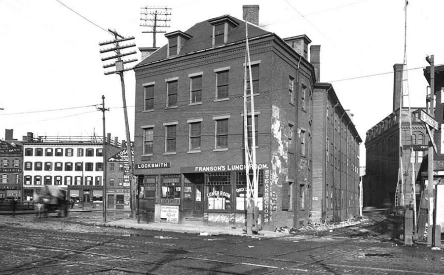
The folks at the Boston City Archives wonder if you can place this scene. See it larger.
Neighborhoods:
Topics:
Like the job UHub is doing? Consider a contribution. Thanks!
Ad:
The folks at the Boston City Archives wonder if you can place this scene. See it larger.
Like the job UHub is doing? Consider a contribution. Thanks!
Ad:Help keep Universal Hub going. If you like what we're up to and want to help out, please consider a (completely non-deductible) contribution.
Comments
Quick Guess
By Suldog
Mon, 12/30/2019 - 10:11am
Commercial Street?
Suldog
City Sq
By BUE
Mon, 12/30/2019 - 10:12am
Railroad along the building goes into the Charlestown Navy Yard.
Warren Ave - Charlestown
By Lowermills02124
Mon, 12/30/2019 - 10:29am
Warren Ave - Charlestown
Another angle
By Hardy Har Har
Mon, 12/30/2019 - 10:41am
https://www.ebay.com/itm/Photo-1890s-Boston-MA-2-6...
Charlestown
By Danrac99
Mon, 12/30/2019 - 10:38am
Warren St?
Warren AVENUE, not Street
By Charles Bahne
Mon, 12/30/2019 - 11:06am
This was between City Square and the river. Warren Avenue was the street that led from City Square to the Warren Bridge, which used to cross the river about where the dam is today.
The photo is before construction of the Charlestown Bridge, the bridge that is there today, which formerly carried the Orange Line Elevated.
The area has been entirely changed twice: once when the Charlestown Bridge was built in 1901, and second in the 1990s when the tunnel to the Tobin Bridge was built (replacing elevated highway ramps). In the 1990s construction, the north end of the Charlestown Bridge was rebuilt so that it curves to the west. Before that the north end of the bridge curved to the east.
There must have been a previous Charlestown Bridge
By Ron Newman
Mon, 12/30/2019 - 6:36pm
because my 1856 map of Middlesex County shows a bridge where the Charlestown Bridge is now, as well as the adjoining Warren Bridge.
Charles River Bridge
By Charles Bahne
Mon, 12/30/2019 - 8:13pm
That would have been the Charles River Bridge, built in 1785. It was not on the exact site of the current Charlestown Bridge, but slightly to the east of it. At the Boston end, it lined up with Prince Street. At the Charlestown end, there was a street called Charles River Avenue leading up to City Square.
The Charlestown Bridge -- soon to be demolished -- was purposely built adjacent to, not on the same site as, the older bridge. That meant the old bridge could be kept fully open until the new one was completed. And by being slightly to the west, it had a direct street connection with North Washington Street in Boston.
How long before someone brings back Franson's Lunch?
By O-FISH-L
Mon, 12/30/2019 - 1:23pm
How long before some woke entrepreneur brings back Franson's Lunch & Locksmith? The stories of George Washington ate here and Paul Revere made metal keys write themselves.
Is this the building today?
By Gary C
Mon, 12/30/2019 - 1:28pm
I think so, but I can't tell for sure.
https://goo.gl/maps/DMDNLci5WczVhFvp9
This is the view today
By Charles Bahne
Mon, 12/30/2019 - 3:43pm
Or about as close as you can get...
https://goo.gl/maps/3AmbTnzzGfY7pnQF8
As I noted in my earlier post, the entire neighborhood has been changed twice in the 120 or so years since the photo.
And ignore the "Warren Ave" label that Google Street View has added -- that's incorrect. Warren Avenue went at right angles to the street in the Google view. The street in the Google view is roughly where the railroad tracks were in the original photo.
No answer?
By Gary C
Tue, 12/31/2019 - 11:22am
Thanks for playing folks....
The Answer
By Boston City Archives
Tue, 12/31/2019 - 12:51pm
Thanks for playing, folks! This photo shows the Warren Ave Railroad Crossing in Charlestown on March 10, 1896.
Add comment