
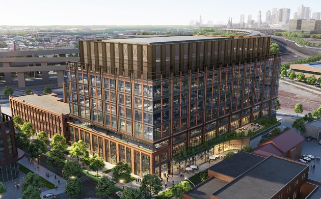
Rendering of phase 1 of the proposal.
A pair of developers say they will soon file plans for the first phase of their proposal for three clusters of buildings with 851 housing units, 200 hotel rooms and more than 1.75 million square feet of life-sciences labs and offices on the western and northern sides of Sullivan Square.
The proposal by Boston-based Rise Together and Trax Development will require the demolition of numerous existing buildings from the Somerville line to the Mystic River along Cambridge Street. When done, the developers promise nearly six acres of parks around Sullivan Square, which most people outside the area now know mainly as a traffic-clogged rotary on the way to somewhere else.
The proposal is the latest in a series by different developers to transform Sullivan Square. In addition to the ongoing Hood Park development, a developer has proposed a 29-story residential tower at Mystic Avenue and Dorrance Street.
In a letter of intent filed with the BPDA, Rise Together and Trax say the first phase of their work will focus on several parcels, totaling 6.3 acres, along Cambridge and Roland streets from the Somerville line to just past I-93, where they are proposing 160 housing units and 906,000 square feet of life-sciences space, as well as new parkland and a "shared streetway zone" for both pedestrians and motorists along Roland Street.
They developers are calling this part of their project Inner Belt, a name more commonly used in neighboring Somerville for the land left over from an interstate that was never built. The complex will wrap around the Tavern at the End of the World on Cambridge Street, which is named because it's the last watering hole before Somerville, isolated from the rest of Boston by the I-93 deck, to which the Inner Belt Highway was supposed to connect. Also planned: Green space from Sullivan station to Hood Park.
The developers say this work will turn Charlestown's forgotten corner into a "lively, walkable realm," that, when coupled with a Green Line Extension station just a ten-minute walk away in Somerville, will make the area "a key link between the lively, economically vibrant urban hubs of Kendall and Union Squares."
This cluster will then join up with another cluster at Cambridge and Spice streets. The third cluster, to be called Mystic Square, will include land from the Alford Street bridge, down Arlington Avenue and Temple and Sherman streets.
In their letter of intent, the developers said they will file separate plans for each of the three clusters, but that they expect to work with a common "impact advisory group" of local residents, appointed by the BPDA, to oversee planning for all three projects.
Like the job UHub is doing? Consider a contribution. Thanks!
Ad:
Comments
Money to Wu
By Stu Green
Wed, 09/22/2021 - 11:44am
Looks the Rise Together CEO has given $1500 to Wu over the past 18 months. Nada for AEG.
I'm pretty sure this plan is
By DrewD
Wed, 09/22/2021 - 12:15pm
I'm pretty sure this plan is far enough away that there isn't a risk, but I want to make it clear to the world that if the painting of a four eyed, pink wolf with a rather large bosom is ever destroyed I will riot in the damn streets. It is a masterpiece of obscene artistry.
For what it's worth....
By boo_urns
Wed, 09/22/2021 - 3:07pm
I'm pretty sure there are at least a few of these around. There's one on the wall along the Fitchburg tracks behind Market Basket (Somerville), for example.
Is art the mere image or the process too?
By DrewD
Wed, 09/22/2021 - 4:05pm
Would you destroy Picasso's sketch book just because you knew a final product existed!?!?!
Also, while I know this isn't the only one, I didn't know any specifics about where the others were. Looks like I need to take a trip on the Fitchburg line. Or to the street behind Market Basket.
If you squint just hard enough....
By boo_urns
Wed, 09/22/2021 - 8:51pm
You can see it from Google Maps Street View:
https://www.google.com/maps/@42.3811768,-71.1018589,3a,75y,199.07h,90t/data=!3m7!1e1!3m5!1sMZI-8RtgQXeU4xzye0aTCQ!2e0!6shttps:%2F%2Fstreetviewpixels-pa.googleapis.com%2Fv1%2Fthumbnail%3Fpanoid%3DMZI-8RtgQXeU4xzye0aTCQ%26cb_client%3Dmaps_sv.tactile.gps%26w%3D203%26h%3D100%26yaw%3D194.32254%26pitch%3D0%26thumbfov%3D100!7i16384!8i8192!5m1!1e2
(I cannot for the life of me to get hyperlinks to work on this site; copy and paste that complete URL for street view)
Washington Street runs behind those tracks, but you won't see it because it's on the track side of the separating wall on the inbound track side.
Like you, I know I've seen it in other spots but I'm having a heck of a time remembering where.
#ProTip
By Ari O
Thu, 09/23/2021 - 5:25am
If you click the three dots on Streetview and choose "share or embed" it will give you a shortened URL you can more easily paste into UHub. Either that or paste it somewhere like bit.ly or tinyurl.com and it will shorten it to a more UHub-friendly format.
My understanding was that
By anon
Wed, 09/22/2021 - 2:50pm
My understanding was that area was a wasteland on purpose, to keep the poors of slummerville from being able to access tony charlestown on foot? though I guess condos in east somerville are a million dollars so keeping a barrier of traffic and anti-pedestrian landscaping is less vital.
Wow. That's the kookiest
By anon
Wed, 09/22/2021 - 7:54pm
Wow. That's the kookiest theory I've heard in a while.
How would that even work? Who are all these powerful rich people living in northern Charlestown who enjoy living next to a traffic-clogged mess of vacant lots because that's somehow better than having good sidewalks, and are able to force the city government to block all improvements to the area?
I don't think that was the reason
By CuteUsername
Thu, 09/23/2021 - 1:08am
Charlestown and Somerville were both kind of "gritty" when the relevant decisions were made. I think it's just the car-centric mentality interacting with the weird geography that Sullivan Square had to begin with as a result of originally being the only land connection between Charlestown and the mainland.
So you start out with this weird intersection and then they turned the intersection into something cars can drive through faster, then they built a giant expressway next to that because it seemed like a convenient place to put it, then they moved the train station and put a parking lot in front of the new station which is partly a reaction to the car-centric nature of the neighborhood but also reinforces it.
Industrial areas were set aside for, well, industry.
By Section77
Thu, 09/23/2021 - 9:50am
Somerville was a much different place back then.
I’m sure this ought to
By anon
Wed, 09/22/2021 - 6:18pm
Lower the cost of housing in greater Boston right?
Alternate Universe
By Ari O
Thu, 09/23/2021 - 5:48am
There's an alternate universe in which 93 gets canceled along with the rest of the 1970s-era highways; it was only retained because it was close enough to completion that canceling it would have cost more than finishing it.
Imagine a world in which I-93 still ends in Medford. On the one hand, traffic from the north has to use a combination of McGrath/O'Brien and Rutherford Avenues to get Downtown. So the overhead ramp at Sullivan Square is probably still there, and the current Rutherford Avenue plans are harder to implement. This becomes a huge bottleneck, akin to where Route 2 ends at Alewife, while the four-lane portion of 93 through the Fells looks as overbuilt as Route 2 does between Arlington and Lexington. Like Alewife, there might well be a huge(r) park-and-ride structure at Wellington to accommodate some of this demand.
On the other, the Central Artery probably never gets as clogged as it wound up because from the north it is fed only by Route 1, not by Routes 1 and 93. So, does it ever get replaced? It was so overbuilt that it wasn't structurally unsound in the '90s, but completely oversubscribed. Maybe the Big Dig is just the Ted without the portion under downtown? Of course, with the structure approaching 75 years old, if it were still in use, it might be easier to talk about tearing it down and replacing it with nothing, or with better transit service.
Meanwhile, the only Commuter Rail line to lose ridership between 1972 and today was the Reading/Haverhill Line, because once 93 opened, a bunch of transit users decamped for the highway. Without 93, what happens there? It's probably much more likely that the Orange Line is extended to Reading using the express track between Community College and Wellington. Which means that service from Haverhill all winds up on the Lowell Line. Maybe the T instead chooses to split the Orange Line and run a branch over the old Medford Branch and then up 93 to 128 (or something) given the highway dead-ending at Revere Beach Parkway.
How does 128 look? Traffic to the south probably all follows 128, and the traffic between Exit 37 (it will always be Exit 37) and the Braintree Split is potentially more apocalyptic. There's probably a two-lane ramp from 93 south to 128 south, and all of Exit 37 probably gets a rebuild that it should have, because trying to push that much traffic through a cloverleaf is impossible.
What about local roads in Boston and Cambridge? Is there as much demand on surface streets and river roads in and out of the LMA and Kendall? Does Kendall become Kendall in the way that it does if it's harder to reach from the north (probably, since it's already a pain to reach from 93)? Is Downtown Boston more or less vibrant with less highway access? (I'd say more, but who knows.)
Reading/Haverhill Line
By ScottB
Thu, 09/23/2021 - 1:22pm
93 North wouldn't be the only reason it has lost ridership since 1972; the Haymarket North Extension of the Orange Line would have also had an impact since Malden gained access to the MBTA subway system. Local bus feeder lines from Melrose and Wakefield to the Orange Line would also have reduced demand on the Commuter Rail since a Combo/Link pass would be much, much cheaper than a Zone 1 or 2 pass.
Also, FWIW, I think the experience of the extension of the Red Line to Alewife and no farther tells us that the Orange Line would have still ended at Oak Grove. It is no coincidence that Oak Grove is less than 1000 feet from the Melrose town line. The Red Line ends at Alewife because Arlington and Lexington didn't want "those people" in their towns and the same would have been true for Melrose/Wakefield/Reading.
The jobs would still have left the urban core in the 1960s and 1970s and IMO would have been somewhat slower to return with worse highway access.
EDIT: Oh, and of course the huge commuter parking structure at Wellington would have also drawn traffic away from the Commuter Rail. Again, gas + parking + subway fare was probably comparable to or cheaper than the Commuter Rail fare for many years (and it still is!) and even as unreliable as the Orange Line can be, a train every 5 to 15 minutes sure beats waiting two hours if you miss your Commuter Rail train.
All good points
By Ari O
Thu, 09/23/2021 - 4:34pm
But even on corridors with competing service, ridership grew. The Alewife extension didn't sap Fitchburg ridership, for instance.
If Route 1 was the only highway-ish road from 128 to the city north of the Pike, I wonder if there would have been more appetite for transit along I-93. It's sort of a dead zone now. Maybe GLX would have gotten built earlier, but since it's Big Dig remediation, it may have never gotten built at all.
Wellington-Medford-Woburn via the old Medford Branch and 93 would be a nice branch of the Orange Line. Alas.
GLX
By ScottB
Thu, 09/23/2021 - 8:34pm
Wouldn't have been much help to commuters from north of Boston. There's nowhere (for non-residents) to park in Somerville and by the time one would have driven that far on McGrath Highway, it's really not much farther to go all the way into Boston. GLX is about local demand from Somerville to access the subway network, rather than having to take buses to Sullivan, Lechmere, etc.
As crappy as the Fitchburg Line is, Rt. 2 is worse. Plus the Alewife Extension provides an improvement to the Fitchburg Line by offering a connection to the Red Line at Porter. You can go from Concord or Waltham to Harvard Sq. without having to make a double connection via North Station and Park St. (or Downtown Crossing).
The Orange Line connection at Malden Center doesn't offer much for Reading/Haverhill line commuters since you can connect to the Orange Line at N. Station.
Got waders?
By SwirlyGrrl
Thu, 09/23/2021 - 8:37pm
You'll need them by 2100 or so - possibly earlier.
6 ft of sea level rise here: https://coastal.climatecentral.org/map/16/-71.0731...
If you're going to hand-wring about that
By ScottB
Fri, 09/24/2021 - 11:46am
You might as well do the same about every single structure that has been or will be built in Kendall Sq., not to mention the entire Assembly Square/Row development.
The vast majority of us here will be lucky to be alive in 2100.
Add comment