Hey, there! Log in / Register

Immaculate storrowing
By adamg on Wed, 02/23/2022 - 9:48am
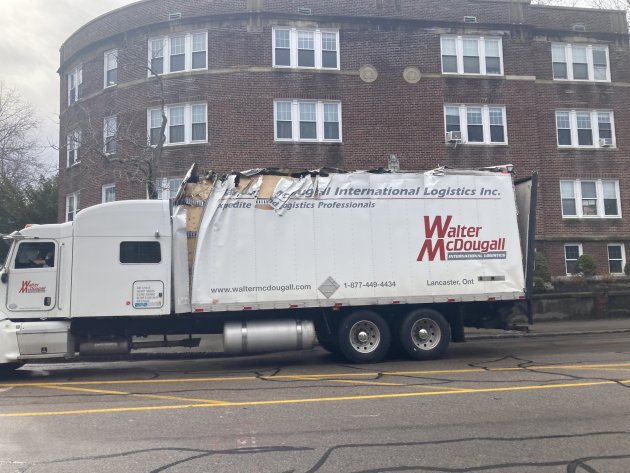
It's a real puzzler. Hugmajesty spotted this truck with a fresh haircut this morning on Washington Street in Brookline, where there are no bridges. Where could it possibly have storrowed?
Neighborhoods:
Topics:
Free tagging:
Ad:
Support Universal Hub
Help keep Universal Hub going. If you like what we're up to and want to help out, please consider a (completely non-deductible) contribution.
Comments
Riverway bridge over route 9 in Brookline Village
...is exactly 1 mile away and is on the lower side. The truck is admittedly pointed toward Brookline Village - not away - but it could simply have banged a U-turn.
Emphasis on "banged"
Emphasis on "banged"
Legal height?
That bridge is 13'6" on the direction headed to Brookline Village and 13'4" in the other direction. If he's over 13'6", I think he has to mark as oversized and have an escort...There's no way that flatbed is over 13'6". I have to wonder if he made it there from Storrow.
He also somehow smacked the left side first/only? (there's a frontal photo on the linked tweet) Which is even more bizarre because most bridges are going to be higher in the middle if there's any difference at all.
Brookline Village pedestrian bridge over Route 9 - demolished?
There used to be a large pedestrian bridge over Route 9 between Riverway and Washington/Harvard streets. I don't see it on Google aerial view, though, so I guess it was demolished recently?
It's been gone awhile now
Since 2015. It's not your father's Brookline Village anymore: They've even got a hotel now.
Going further back, the reason that part of Brookline Village has long been a soulless bit of highway has to do with, of course, demolition related to the planned construction of an interstate right through the area, the inner belt that Gov. Sargent killed in 1971. Here's a view from roughly where the overpass used to be, looking west on Rte. 9 (the firehouse is still there, at least, as is the big old bank across Rte. 9, although it's now a marijuana mart):
Source (used under this Creative Commons license).
?
The Innerbelt and 95 would not have gone near Brookline Village.
The highway as supposed to go where the Orange Line is with the Inner Belt going from Ruggles west by the MFA, through Audubon Circle and then looping to Central Square and onto Somerville. The east loop is not Melnea Cass.
There was some initial planning in the Master Highway Plan at the start in 1948 to work Brookline Village in, but by the time all this was knocked, that plan had been kicked in favor of screwing poorer areas over Brookline.
The Brookline Village thing was just urban renewal everyday late 1960's traffic planning and big project.
Any planning to get to the planned highway would have still had to dealt with Mission Hill and Huntington Avenue.
This part of Brookline Village was demolished to put some of Brookline's projects as close to Boston as possible. Plus allow 10 Brookline Village and the Brook House to get built.
I also think it was done to be a sort of "urban decay" firebreak to keep Brookline out of the urban fabric of Roxbury / Mission Hill of the time.
Not a Storrowing?
That kind of looks like he scraped up against the side of something.
Brighton I-90 underpasses?
North Beacon Street, Parsons Street, and Brooks Street all pass under the Mass Pike in Brighton, north of Oak Square. I don't know how high any of these clearances are.
How can you tell it was
How can you tell it was freshly Storrowed and not born that way?
Not a good look for…
….so called logistics professionals.
...unless it's a really
...unless it's a really creative and realistic-looking ad wrap meant to suggest that their shipping vehicles move SOOOO fast, the atmospheric drag and friction strip the paint off the sides and pull at loose seams.