Hey, there! Log in / Register

Extending the Chestnut Hill Reservoir
By adamg on Tue, 08/08/2023 - 4:09pm
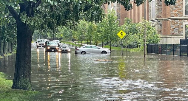
A roving UHub correspondent decided discretion was the better part of driving valor and turned around when he saw how flooded St. Thomas More Road, between the BC lower campus and the Chestnut Hill Reservoir, was after today's torrent.
The reason it's called the lower campus is because it's down from the Heights for which BC is better known. In fact, until 1949, most of it was underwater, part of a second reservoir, known as the Lawrence Basin, just across the street from what we know call the Chestnut Hill Reservoir, as seen here in this 1893 photo by the Metropolitan Water Board (note the large pumping station at the top, preserved today as the Waterworks Museum, as well as the smaller pump house off to the right, which still stands, although no longer in use, since the Brookline reservoir to which it once diverted water from Lake Cochituate is no longer in use, either):

In 1948, the state declared the Lawrence Basin "inactive" because of construction of the far larger Wachusett and Quabbin reservoirs, and sold the basin and adjoining land to Boston College, which filled it in and put a football stadium and dorms on the newly dry land.
Meanwhile, Ari Ofsevit reports part of Charles Street became a lake - with an ad hoc stream feeding the Public Garden Lagoon, which came close to overflowing its banks. Like St. Thomas More Road, Charles Street was once underwater as well, as part of the Back Bay, back when it was actually a bay, and the original inhabitants would build fish weirs there.

Topics:
Ad:
Support Universal Hub
Help keep Universal Hub going. If you like what we're up to and want to help out, please consider a (completely non-deductible) contribution.
Comments
Turn Around - Don't Drown!
Excellent choice!
The National Weather Service approves this action.
Here's a catchy country tune to remind y'all:
I remember speaking with a town official from Newton. She was able to get a handle on where it might flood - and where it had been flooding - outside of river floodplains by looking at very old maps of streams, swamps, and ponds.
Rising water
I heard that some folks just didn't have a choice in this storm. We got 3 inches of rain in an hour, and people didn't drive into it, but were just caught by rising water.
That does happen
But the caption on the photo said that the photographer made a wise choice.
And, in most cases, people do have a choice. Too many people are either unaware of the risks or think that because they drive a truck or an SUV they can just float on. Just a reminder to pay attention to the weather and choose your routes accordingly.
When FEMA was redoing the
When FEMA was redoing the flood maps, there was a lot of grumbling and saying that "I don't live in a flood zone", when FEMA says you do. Then FEMA relented and now revised the flood maps down. I just hear about more and more flooding here.
Pump house or gatehouse?
I believe the structure you have identified as "the smaller pump house off to the right" is actually the terminal gatehouse for the Sudbury River Aqueduct. The Cochituate Aqueduct brought water to the Brookline Reservoir but also contributed to the Lawrence Basin, and that gatehouse does still stand but is obscured behind the trees in the photo. There was no pumping associated with the gatehouse in the photo. [I really like the photo, by the way.] Both the Cochituate and Sudbury River Aqueducts were gravity fed without any pumping at all. The Sudbury still is available for backup in case of emergency (mainly to ensure water supply for fire protection).
I have a collection of Sudbury and Cochituate Aqueduct photos here:
http://www.middlesexcanal.org/aqueducts/cochituate.htm
and
http://www.middlesexcanal.org/aqueducts/sudbury.htm
Fascinating!
Thanks for the post!