

T workers weren't even done putting up a new map at Government Center when somebody rushed over to figure out how to get from A to B.
The MBTA today kicked off a two-year, $500,000 project to replace every single map at T stations. Download a hi-def copy of the new map (870k PDF).
Highlights: The updated maps show a new Sliver Line 4, which will provide direct service from Dudley to South Station starting next month (on surface roads; no, the T didn't build a secret tunnel), and, on the Green Line, riders will get to see which line actually goes all the way to Lechmere (the E) and which end before Lechmere:
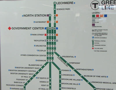

The project began this morning at Government Center. In addition to the new Silver Line route (fun fact: Next month the Silver Line will be missing a line just like the Green Line, with the elimination of the 3; its routes will be the 1, 2, 4 and 5), the maps also show connecting bus lines at a number of stations.
Among the maps to go: 40-year-old neighborhood maps at Government Center, Copley and Bowdoin, which now show numerous buildings that no longer exist - or were never built (along with a certain elevated highway):
Where's the police station next to the Garden?

Mythical Boston where there's an office building instead of a Holocaust Memorial and a pedestrian bridge across Congress:

Like the job UHub is doing? Consider a contribution. Thanks!
Ad:
Comments
Where's the Tip Building?
By Ron Newman
Mon, 09/21/2009 - 11:57am
If you mean the Tip O'Neill Federal Building, that would be well outside the frame of your photo, on Causeway Street. (Does the full map show the Hotel Manger at that location?)
Waste?
By DVDWow
Mon, 09/21/2009 - 11:59am
Am I the only one who thinks it's a bit ridiculous to spend $500,000 to update maps which will only be valid a couple of years with the upcoming Green Line extension?
Awesome
By Michael
Mon, 09/21/2009 - 12:06pm
Best laugh I've had all day. Thanks.
You are very, very
By anon
Mon, 09/21/2009 - 12:08pm
You are very, very optimistic if you think the new branch will be done in a couple of years. Maybe they'll restore the temporarily (25 years) suspended E line to Forest Hills!
they'll do that....
By Sarcastic Sam
Mon, 09/21/2009 - 2:02pm
...right after they take down the Temporary tolls on the Pike and repeal the Temporary state income tax.
-----------------------------------------
who and the what now?
That's a good point, but
By shai
Mon, 09/21/2009 - 12:09pm
That's a good point, but actually that sounds like a pretty good investment considering that the maps include major bus lines. My guess is that the savings / extra income that result from people taking the bus instead of the subway from time to time will more than offset the costs.
extra income?
By Pat
Wed, 12/30/2009 - 2:51pm
The bus is cheaper than the subway. If anything, it would be lost revenue. But this novel idea of providing passengers with information is quite groundbreaking.
28X
By Arborway
Mon, 09/21/2009 - 12:15pm
Not to mention the 28X Silver Line extension.
The 28x is not proposed as a
By anon
Mon, 09/21/2009 - 12:27pm
The 28x is not proposed as a Silver Line extension, just an updated version of the 28 that will still go from Ruggles to Mattapan
The optimistic opening date
By anon
Mon, 09/21/2009 - 12:23pm
The optimistic opening date for Green Line to Somerville is 2014. 2017 will probably be more like it.
IMO, the "C goes to North Station" and "E goes to Lechmere"
By roadman
Mon, 09/21/2009 - 12:34pm
features of the new Green Line maps just underscores how T management doesn't really care about improving the quality of service for people east of Government Center.
I picture a future T planning meeting going something like this:
"We've been getting requests from Somerville and Cambridge city officials that we should run additional trains from lines other than the E out to Lechmere."
"Oh, we could never do that. Think of all the brand new station maps we'd have to replace."
I have to say, I really like
By HenryAlan
Mon, 09/21/2009 - 12:42pm
I have to say, I really like these maps, with a few minor and ultimately pointless quibbles. Why do we get the Worcester line all the way out to Auburndale, but not a single in Boston station on the Needham line? There are also some buses that they should add, but overall, I give a big thumbs up for the inclusion of any bus lines. Next step, turn those suckers into trolley lines, and we'll have quite the system.
And $500,000 actually seems pretty inexpensive to me.
Oh, great
By Eighthman
Mon, 09/21/2009 - 1:18pm
So now that shower curtain is out of date?
So where can we buy those sweet old maps?
By greenlinetobrooklyn
Mon, 09/21/2009 - 1:36pm
I'd love to have one...
I hope we shouldn't be worried....
By Charlotte k
Mon, 09/21/2009 - 1:54pm
...by the very limited buses displayed. I wonder why they selected those particular buses. Or do they plan to cancel all the rest of them??? I guess they made an attempt to include the ones that cover broad territory, which really is a good idea, but it will confuse some people.
I love that they have retained the description "Mattapan High Speed Line"
Key bus routes
By alex
Mon, 09/21/2009 - 2:26pm
Bus routes with high ridership and high frequency
http://en.wikipedia.org/wiki/Key_MBTA_bus_routes
Downtown Crossing could use some help
By adamg
Mon, 09/21/2009 - 2:04pm
Shot today:
Except for the E li(n)e,
By ckd
Tue, 09/22/2009 - 3:59pm
Except for the E li(n)e, that map is actually not too out of date. It has the Alewife extension (1985?), the Southwest Corridor section of the Orange Line (1987), and Andrew shown as accessible (1990?).
You could probably date it more precisely by looking at the now-accessible stations like Airport, Charles/MGH, and North Station.
Very interesting. The bus
By J
Mon, 09/21/2009 - 2:21pm
Very interesting. The bus lines at first seem to have crowded the map, but on second glance theyve been done very well. Im always shocked by how few people in Boston know about any bus line except for the one that passes in front of their door.
Someone asked why those. A casual glance indicates that they did the top 15 lines by ridership. I would know. I made a google map with the most used bus lines and those are the one I mapped. The crosstown routes are absent, because they dont get as many riders.
Yawkey station wasnt included (its on the old maps(and I wonder why)
Other than that, the Sl4-SL5 thing is very confusing, and I also thought that 28x would be an extension of the silver line. The fact that SL3 is dead forever but they didnt use that number is amusing (they had no problem using the dead SL4 number)
I dont like the new map showing where each branch of the green goes, mostly because it prevents them from changing that.
Im also pretty surprised theyre doing this now, and not waiting to put in the expanded green line.
As for the neighborhood maps....Ill miss them. Theyre like little history lessons. Are they being replaced or just removed?
Neighborhood maps
By adamg
Mon, 09/21/2009 - 2:29pm
Sorry for not being clear: They're being replaced with updated maps, not eliminated (for example, the one now at Government Center shows the Greenway, not the Central Artery).
Thats good. Now email the T
By J
Mon, 09/21/2009 - 2:43pm
Thats good.
Now email the T and tell them that Kenmore should have a handicap sign, as theyve forgotten to include it. And I want Yawkey in there too.
Also, it appears that Silver line 4/5 service will not take you from south station to the green line, but youll have to transfer to another bus....
A great place for the SL3...
By Cleary Squared
Mon, 09/21/2009 - 8:55pm
...would be to replace the Route 32 between Wolcott Sq and Forest Hills, instead of squishing everyone onto those narrow 40 foot buses. Hyde Park Ave, almost the entire route save a couple of places where the road narrows, is a prime spot for Bus Rapid Transit, as between Walk Hill St and Metropolitan Ave, Hyde Park Ave is four lanes.
The Route 32 bus between Forest Hills and Cleary Square would still exist, but the Wolcott Sq route would finally get the extra room it needs. And, if the T were super-ambitious, they'd extend the SL3 through to Dudley, and perhaps route it all the way to Back Bay Station via Columbus Avenue.
Just a thought.
The map has been updated
By J
Sat, 03/12/2011 - 1:22am
The map has been updated again. The SL4 line is much less confusing, as it's no longer a triangle. Yawkey was added, and Kenmore, Arlington and Copley have wheelchair logos.
Old-new map can be seen here
http://www.boston.com/news/local/massachusetts/art...
New-new map can be seen here
http://mbta.com/schedules_and_maps/subway/
Im sure the more obsessive could point out further tweaks.