By adamg on Mon., 8/22/2016 - 10:22 am
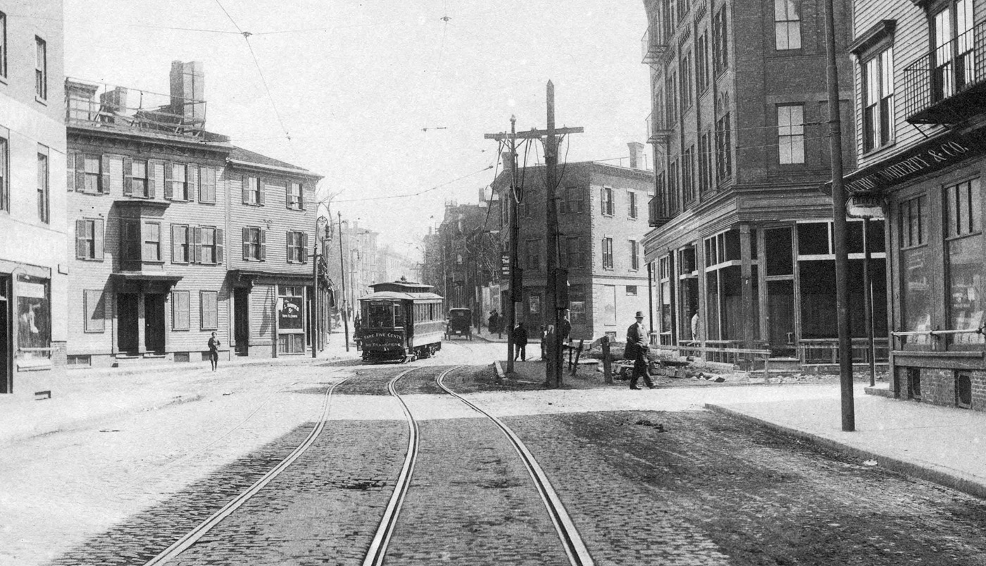
The folks at the Boston City Archives wonder if you can place this scene. See it larger.
Topics:
Neighborhoods:
Like the job UHub is doing? Consider a contribution. Thanks!
Ad:
The folks at the Boston City Archives wonder if you can place this scene. See it larger.
Like the job UHub is doing? Consider a contribution. Thanks!
Ad:Help keep Universal Hub going. If you like what we're up to and want to help out, please consider a (completely non-deductible) contribution.
Comments
Charlestown?
By bibliotequetres...
Mon, 08/22/2016 - 10:53am
There's a paywall stopping me from absolutely confirming this, but Doherty & Co seems to have been in Charlestown in 1915
It does look like where Main St. Forms
By anon
Mon, 08/22/2016 - 11:52am
Like Warren and Main.
Huntington Ave?
By Former South Ender
Mon, 08/22/2016 - 10:57am
Huntington Ave ? Last week?
West End?
By Nate
Mon, 08/22/2016 - 11:03am
Leverett & Barton St in the (now razed) West End around 1900?
toward city square? naaah
By scollaysq
Mon, 08/22/2016 - 11:18am
Patrick Doherty's liquor store is listed at 13 Chelsea Street, Charlestown. But if that's the area, it's beyond unrecognizable.
Definitely looks like
By DTP
Mon, 08/22/2016 - 11:57am
Definitely looks like Charlestown... my guess is maybe Warren & Park, looking south down Warren? Street grid seems to match.
Records and Archives In the News
By theszak
Mon, 08/22/2016 - 2:14pm
RAINbyte
Records and Archives In the News
http://paper.li/RAINbyte/rainbyte?edition_id=6a463...
You're all wrong, it's a trick question
By Imma Dork
Mon, 08/22/2016 - 3:37pm
The catch is, the description says that a mass transportation vehicle arrived "on time!"
The Answer
By Boston City Archives
Mon, 08/22/2016 - 4:14pm
Thanks for playing, folks! This is Chelsea St at Foss St in Charlestown. The date is May 10, 1920.
Where was or is Foss Street?
By Ron Newman
Mon, 08/22/2016 - 5:26pm
None of the online mapping services I tried can find Foss Street in Charlestown. Has it been renamed to something else? Is it in the Navy Yard?
Per the Boston Horse and
By DTP
Mon, 08/22/2016 - 6:44pm
Per the Boston Horse and Street Railroad Guide, page 197, Foss St intersected Chelsea St somewhere around where the portal to the route 1 City Square Tunnel is now. Nearest extant streets are Chestnut and Henley, and it was between them and City Square.
Said book was published in 1887, for reference.
Interesting... never heard of
By anon
Mon, 08/22/2016 - 6:57pm
Interesting... never heard of this book. Thanks for mentioning it!
Sam Walter Foss
By theszak
Mon, 08/22/2016 - 7:39pm
Sam Walter Foss, former Librarian of the Somerville Public Library
https://books.google.com/books?id=tJ-N5uvGaNcC&pg=...
1922 Real Estate Atlas link
By Charles Bahne
Mon, 08/22/2016 - 8:48pm
Here's a link to a 1922 Real Estate Atlas of Charlestown, courtesy of the Massachusetts State Library:
https://www.flickr.com/photos/mastatelibrary/sets/...
Foss Street and Chelsea Street are on Plate 2 of the atlas. Go to the above link, then click on the image of Plate 2 to get an enlargement. Wooden buildings are shown in yellow, brick ones in red.
The photo is looking northeast on Chelsea Street (to the right on the atlas plate), with Foss Street coming in on the right. Henley Street comes in on the left, in front of the two wooden buildings.
Prior to the construction of the City Square Tunnel (Central Artery North Area or CANA) in the 1990s, Chelsea Street was further north than it is today, roughly where the highway leading to the Tobin Bridge is now. This photo would have been near the present-day condos on modern Chelsea Street, between City Square and the Navy Yard.
Chestnut Street, as shown on the atlas plate, still mostly exists, except that the southernmost 2 or 3 houses were removed to make way for the Tobin Bridge. The street has since been rerouted into a U shape, looping back north to Adams Street.
The only part of Henley Street that survives today is the segment between Main and Warren streets. As you'll see from the atlas plate, it used to extend across Warren Street, across Park Street, and across Chelsea Street, ending at Gate 2 of the Navy Yard (which still exists).
Water Street, at the bottom of the plate, is now part of Constitution Road.
According to the street numbers on the atlas plate, Doherty's store was at 61 Chelsea Street. Maybe they had moved up the street since the earlier reference. The 1918 "Boston Register and Business Directory" (available from Google Books) shows Doherty at 61 Chelsea, with number 13 Chelsea (and several adjoining stores) listed as vacant.
Here's more or less a current Google Street View, except that the road used to be maybe 150 feet off to the northwest, or to the left as you see it here:
https://goo.gl/maps/9qhe3mDh7Kn
Add comment