Hey, there! Log in / Register

On the impossibility of mapping Boston neighborhood lines
By adamg on Thu, 10/10/2019 - 11:23am
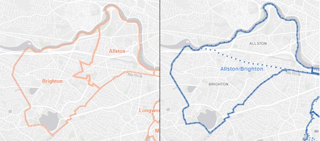
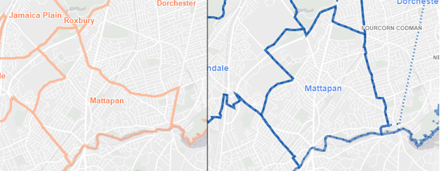
BPDA's version of Allston/Brighton on the left, DND's on the right.
One of the things that will drive any Boston reporter or editor insane over the years is trying to figure out just where the lines are between Boston neighborhoods. Is the Hotel Alexandra in Roxbury or the South End? Would the proposed Roxbury Prep school be in Roslindale or West Roxbury? Where, exactly, does Comm. Ave. stop being Allston and start being, um, whatever that thin strip is that connects it to the rest of Boston?
City planners face the same exact problem.
Some folks at the Department of Neighborhood Development created an interactive map that lets you see the differences between what DND considers the borders of a particular neighborhood and what the Boston Planning and Development Agency consider its borders.
The DND staffers created the map as they were geocoding their data so that they could meet requests for neighborhood data that matched up with both agencies' definitions of where one neighborhood ends and another begins.
Also see Bostonography's attempt to crowdsource Boston neighborhood lines.
Neighborhoods:
Ad:
Support Universal Hub
Help keep Universal Hub going. If you like what we're up to and want to help out, please consider a (completely non-deductible) contribution.
Comments
allston/brighton
I've always understood it to be like this: Allston is a subset of Brighton basically centered around the strip of Harvard Ave that goes from Comm Ave up to N Beacon.
Wherever the line between
Wherever the line between Allston and Brighton is, Brighton Ave./North Beacon definitely isn't it. DND's map puts Great Scott in Brighton and the Brighton IHOP in Allston. BPDA's map, with the line along Everett/Warren/Kelton, is much closer to something residents would agree with, at least for A/B.
Pushing the AllBright concept
As a former resident of Allston, I never understood the desire for people and institutions to meld Allston together with Brighton. They really are quite different. The DND map pushes this to the extreme, with a lazy, "Ehh, it's all the same thing" attitude.
Because Brighton used to be a separate town
with boundaries approximately the same as today's Allston-Brighton. Allston began as a section of Brighton with its own separate post office.
Considering that I have a bit
Considering that I have a bit of skin in the game, and considering that Allston is named after Washington Allston, one of the best, if not the best, American painters of his time (look it up, and then look up the MFA's first acquisition) I propose the perverse idea of walking through Allston and Brighton, and calling the areas where art exists, Allston, and the boundaries where it does not, Brighton. I think the map would like different from these. But one is shrinking faster than the other.
The BPDA's map of Allston
The BPDA's map of Allston-Brighton matches what I always thought it was, more or less.
Yup
I lived on Gordon Street in Brighton for a few years. The line runs down the middle of Gordon Street, from Camelot Court up, the west side is in Brighton but the east side is in Allston.
From Camelot Court down, both sides of the street are Brighton, and if you live there you will have to trek all the way up to Brighton Center to retrieve undelivered packages from the post office.
And yes, try explaining this to Verizon, because their computer says the whole thing is Allston.
The DND’s maps look completely off.
Just at first glance, what the DND considers to be Mattapan, Dorchester and Roxbury are completely off. How can these two agencies have such different interpretations of neighborhood boundaries? Can’t we just go by the postal zip codes?
Anything but Zip codes
Take 02121. Dorchester or Roxbury?
Back in the day, when we lived in Brighton, our Zip code was 02146, which was Brookline (but we had to get a Brighton parking permit, voted in Boston elections, etc., so, yeah, we were Bostonians). There's still a similar issue for "Chestnut Hill," which covers parts of Brookline, Newton and West Roxbury (and so you have Harvard Vanguard West Roxbury changing its name to Harvard Vanguard Chestnut Hill/West Roxbury even though they're still in the same building).
Brighton zip codes
They fixed that business with parts of Brighton using the Brookline zip code a number of years ago (late 90s? Early 00s?) when they built the new Brighton post office. Since it was larger than the previous post office, it could handle more mail, so they switched the zip code boundary to the city/town boundary.
Should zip codes follow political boundaries?
I can't think of any particular operational reason why zip codes and mail sorting ought to follow political boundaries. If it's operationally better to deliver mail to parts of Brighton out of a post office building that happens to be located in Brookline, why not?
Agreed. However...
If someone lives in Brighton, it's very confusing to everyone, including insurance companies and ambulances if your mail says Brookline. My mail can come via Timbuktu, but it better have the correct city name on it when it arrives at my door.
Historically 5-digit zip
Historically 5-digit zip codes were mapped to USPS delivery routes. Today for a given street address, the zip code and the associated city-name are almost arbitrary.
Actually, not exactly.
Actually, not exactly.
At the edges the PO used streets as boundaries not the town line
so Corey Rd., not the Brookline line is the boundary.
So on the hill, Brighton neighbors between the town line and Corey
still have a Brookline zip (but now it's 02446) and down the hill closer to Beacon,
some Brookline neighbors have a Brighton zip when the town line moves vs Corey.
(And I remember when there were Brighton (zone 35) & Chestnut Hill (zone67 )slots in the Brookline PO when they handled that mail. Zones preceded Zip codes.)
The swanky part of Brighton
Some of the houses overlooking the Chestnut Hill Reservoir are actually in Boston, not Newton, along with a few addresses on adjacent side streets.
02467
Chestnut Hill is literally the 02467 zip code, and only that. That's where it comes from. I used to be a letter carrier there, and the history told at the post office was that it was developed at the behest of BC, which possibly helped fund its creation.
I'd take that with several pounds of salt, knowing the way mailmen gossip and spin tales, but either way, the zip code is a pretty clear dividing line. People and businesses outside 02467 want to claim Chestnut Hill for the cachet, but it was never really an organic neighborhood. I remember actual debates about whether the use of the name could be controlled.
It was an endlessly entertaining place to be a working-class stiff.
the power of mapping
And that's how the South End stole Lower Roxbury - with merely a drawn line.
many elections have been determined
with mere drawn lines. ask tom finneran.
Going by this Bostonography survey
...the boundaries between neighborhoods are, shall we say, hazy.
http://bostonography.com/2013/neighborhoods-as-seen-by-the-people/
This is an old problem. At
This is an old problem. At this point the City Council should just pass an ordinance setting legal neighborhood boundaries and work with the USPS to associate those boundaries with addresses. If not that, then the city needs a map with overlapping boundaries for all city agencies to reference.
allston
Allston is between the River and Brookline, as far west as the Warren Ave T stop. Everything to the east of Warren Ave that is in Boston, is Allston. Everything West of it is Brighton.
Go by the maps of the towns
Go by the maps of the towns/villages prior to annexation by Boston.
Not always helpful
Allston was part of Brighton, and never a separate town.
Jamaica Plain was part of Roxbury (and then, for a while, mostly part of West Roxbury), and never a separate town.
Roslindale was part of Roxbury, and then part of West Roxbury, and never a separate town.
Mattapan was part of Dorchester, and never a separate town.
South Boston was never a separate town; I think a piece of it was annexed from Dorchester, and another part was part of Boston from the very beginning (though much of it was once water)
Boston begins at copley sq
Boston begins at copley sq and ends in govt center. The rest is suburbs or other.
Except for how no
Most of the voters and BPS students live in the other neighborhoods. Enough with this "Boston is synonymous with downtown" crap.
The weirdest part of that comment
is that Stevil didn't bother logging in to post it under his user name.
Old City Boundaries
Allston/Brighton and Dorchester/Mattapan are hazy because they were previously part of the same municipalities. The Town of Brighton and the Town of Dorchester. Neither Allston or Mattapan had a separate existence. Roxbury boundaries are clear cut because it was the Town of Roxbury. Just as Hyde Park was the Town of Hyde Park. But the Real Estate people always try to up sell to the “tonier” address.
Partially agree
Yes, the boundary between, say, Dorchester and Roxbury is easy, since that boundary existed until 1870 as a town line.
That said, Allston does think of itself as separate from Brighton, and three parts of the Town of West Roxbury are satisfied that they are Jamaica Plain, Roslindale, and West Roxbury themselves. Then there's the case of Mattapan, which is no longer claimed by Dorchester except for some (but certainly not all) old timers. In those cases, I would say the zip code boundary lines should be the go to lines of demarcation.
Jamaica Plain
never an independent town of its own, was split in two when West Roxbury seceded from Roxbury, only to be reunited a few decades later after Boston annexed first Roxbury and then West Roxbury.
I disagree
Jamaica Plain was a part of the Town of Roxbury from 1851 to 1874. While people have muddied the boundary between JP and Roxbury, when in doubt a 1870 map will set you straight.
1872 map of Boston
Here's an 1872 map of Boston. Most of what we now call Jamaica Plain is in the still-separate Town of West Roxbury. However, Centre Street from Hyde Square to Jackson Square is in Boston (annexed as part of the former City of Roxbury).
Well, yeah
So we go to the second default, and the people of Roxbury can stew that a section of their neighborhood was swiped from them.
As a former resident of
As a former resident of Allston and Brighton, I've always understood the dividing line to generally go along Kelton/Warren/Sparkhawk St, with Market Street from Sparkhawk to the Charles serving as the remaining divider. As I understand it, that's the general ballpark where 02134 turns into 02135.
market and sparhawk are
100% brighton, both sides.
Impossible?
Nah. Any realtor can tell you what side of the line this stuff is on without a second thought. Whichever side is worth more.
Original boundary of Roxbury
Roxbury originally extended north all the way to the Charles River, encompassing the Muddy River and Gravely Point. Just take a look at any of the maps from the 1800's. For example, 1849 and 1888. It wasn't until the Back Bay was filled that the boundary of Roxbury started to move south, away from the newly established neighborhood of the Back Bay. And then Boston annexed Roxbury.
Here’s a useful source:
Here’s a useful source: Directory map showing small annexations, 1883. | Library of Congress
https://www.loc.gov/resource/g3764b.ct005985/?
r=-0.175,0.006,1.354,1.352,0.
where is 1888 map?
Despite being highlighted as a link, nothing happens when I click on "1888".
i always use then
i always use then interchangeably.
There are the legal
There are the legal boundaries recognized and recorded at registry of deeds.
Then there are the “fluid” boundaries that are more circumspect to suit realtors marketing plans, zip code boundaries (which only have to do with mail routes) empowerment zones, politics and development etc.
For instance - TOWNSEND street where Boston Latin Academy is now located is in Dorchester, “Towns-End” Street being where Dorchester ended and Roxbury began.
Mission Hill is Roxbury.
The Alexandra is most definitely in Roxbury as Mass Ave is the dividing line but real estate agents have been calling it Lower South End? Or something like it.
Dorchester is not split into North and South. It is just Dorchester - and guess what - the South Station Post Office is located on Dorchester Ave. One used to be able to drive from the beginning of Dot Ave (border w milton) to the the end where it hits Congress Street right near The Beaver (aka Boston Tea Party Ship). Not sure when that stopped but my parents used to use it as a cut through to avoid highway traffic.
Adding on
Boundaries that are in the grey area are either one locale by voting ward and precinct or a different locale per the DPW (at least back in 2001). Imagine the consternation when we looked up our trash/recycling day, put things out for what we thought was our area, was in fact not. A phone call to the DPW put that to rights and we were finally able to get our overflowing barrels emptied. Thankfully, now you can look these things up by exact address rather than just the street name.
Mass Ave and Washington St was always Boston
See the 1883 map that Byron Rushing posted above. On that map, Mass. Ave. was still Chester Park. Roxbury started about seven short blocks southwest of there.
Maybe on a new-fangled 1883
Maybe on a new-fangled 1883 map the Alexandra would've been in the South End, but in Colonial Times, Boston Neck started roughly at East Berkeley St. and the Alexandra would've been in the swampy no-man's-land between the Boston city gate and the Roxbury fortifications.
http://fredlanga.blogspot.com/2014/01/exploring-boston-mapping-lost-bost...
Point: things change. Also, there are lots of great old maps of this area.
I shall withhold judgement until hearing from
thezak.