Hey, there! Log in / Register

Rising sea levels can't sink waterfront homes that float: Developers propose replacements for decaying Navy Yard pier
By adamg on Sun, 02/14/2021 - 4:09pm
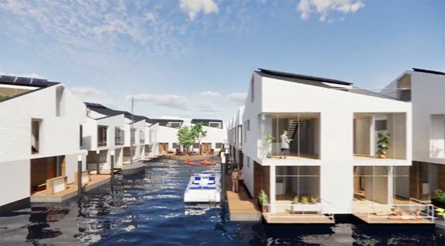
Water-line living, from Navy Blue proposal.
Three developers have proposed replacing a long unused and decaying pier at the Charlestown Navy Yard with housing and various public amenities. Two proposed what would be Boston's first floating neighborhood - a series of homes on floating platforms connected to a new pier that would double as a pedestrian walkway - while the third proposed dealing with higher sea levels by building a higher pier, topped by a building with affordable apartments.
The BPDA, which acquired most of the Navy Yard decades ago, began work on an RFP for what to do with Pier 5 in 2019, a year after concluding that the pier, which dates to 1912, was no longer usable or even repairable.
The agency says it will now take a more in-depth look at the proposals before picking a finalist. At a meeting last week, BPDA planners said they never even thought of floating buildings when it first began looking at doing something with the old pier, and cautioned, "it is very likely that there are numerous regulatory factors that would need to be addressed for such a use to be achieved."
Navy Blue, a consortium of Charlestown Marina, Urban Spaces and Parent + Diamond proposed a series of "live aboard vessels," floated into place and then connected to a pedestrian-only pier with a scenic overlook at the end - with places for residents to dock small boats. Each unit would have solar panels on the roof, with a series of pipes and conduits underneath to provide water and electricity and to collect sewage and rainwater.
Navy Blue proposal (12.8M PDF).
6M Development of the North End also proposed floating units, but eight larger, multi-family platforms, with small canals flowing between the platforms. In addition to housing units, each platform would also have a "pocket park."
Instead of a single long pier, the development would have several pier segments, with bridges connecting them over the canals.
A cafe would sit at the end of the pier system, overlooking a waterfront parklet and the harbor.

6M proposal (50M PDF).
The third proposal, from Urbanica, General Air and the NHP Foundation, takes a more traditional Boston-style approach with its proposed waterfront residences: A more permanently built wharf-like pier - with a higher elevation than the current one - with residential units built atop that, similar to existing wharf units across the harbor in the North End.
The first floor of its proposed building would include a grocery store, space for several smaller shops, a restaurant, a gym and room for the Courageous Sailing Center.
Some 89 apartments would be on the two floors above that, with 66 units rented to people making between 30% and 80% of the Boston area median income. The remaining 23 units would be rented to people making no more than 120% of that amount. Urbanica would team with the non-profit NHP Foundation, which currently manages 25,000 affordable housing units across the US, to run the housing portion of the proposal.
The roof would be divided between a public park and a community garden. The end of the pier would include a small park and an observation platform that would rise and fall with the tides.

Urbanica proposal (30M PDF).
Neighborhoods:
Topics:
Free tagging:
Ad:
Support Universal Hub
Help keep Universal Hub going. If you like what we're up to and want to help out, please consider a (completely non-deductible) contribution.
Comments
Floating community
Boston already has a floating community... Constitution Marina has over 100 boats being lived on with people, singles, couples, children & pets.
They got the right idea.
They got the right idea. Complete with internet and full bar.
Great idea in isolation
Not going to be terribly useful if any roads to it are flooded.
Water taxi
Water taxi
You can pick up a cheap rowboat
for a couple hundred dollars.
Where we're going - we don't need roads!
The broader system seems doable.
In addition to boats, since it's not a long walk to the high ground of Bunker Hill, in principle you could just make the pedestrian walkway longer. Of course if the Navy Yard was constantly flooded that would make this a pretty unappealing place to live, but there's a lot of incremental things you could do to prevent flooding in that area that this would complement. (Of course, if they built more on the high ground that be the simpler way to do this.)
floating this concept
Hurricanes will be interesting.
Hurricanes influence? Not So Much
More like noreasters.
Hurricanes approach from the south. Hence hurricane barriers on south facing harbors such as Providence and New Bedford and places lacking them like Marion and Falmouth take the brunt of hurricanes.
New York - which had to be special and get hit with "Super Storm" Sandy, because you know no ordinary hurricane would hit precious cool New York, they had to feel special to themselves and get hit with, you know, a Super Storm; i.e. a hurricane, also faces south and has no barriers. Hence Lower Manhattan got hit bad, as did the nearby beach communities in North Jersey.
Boston Harbor which faces east, as do harbors, in Portsmouth, Scituate, Plymouth, Salem, and others gets noreasters with more effect. Luckily we have islands which breaks wave motion action, though flow of water still comes in but with a reduced velocity.
Storm Surge is still a thing
Causeway street flooded three times in the last three years.
Why haven't I noticed that?
Why haven't I noticed that? I work across from Hub and haven't seen flooding.
One example of Causeway flooding
In 2018.
Easy
You had a snow day/storm day.
North Washington Street and Causeway
Floods over by the dam.
The state was leasing space at 239 Causeway and let the lease go due to the flooding.
Storm surge,
Meet floating house.
Not sure I understand what you're saying
Maybe I misread your post, but I think it's confusing, and forgive me if I'm saying the obvious.
Yes, hurricanes approach from the south, but wind direction is dependent on how the low pressure tracks. Since the air moves counter-clockwise in a low pressure system north of the equator:
If the low goes offshore (east), then Boston ends with a noreaster.
When the low goes inland, like Irene, we end up with southerly winds.
So, like you said, the Boston area gets hammered with noreasters, while the south coast gets hammered with southerlies.
Magoo sez
Magoo really really likes this idea. In the morning when Magoo has to go pee pee Magoo can just step outside and go pee pee in the ocean. It’s kind of like at the beach when Magoo has to go pee pee Magoo walks into the water about waste deep puts Magoo’s hands on Magoo’s hips and causally looks around and then Magoo proceeds to pee pee. Magoo.
Yeah but the Mold...
A family I know has a summer cottage by the sea and goes boating. The downside to an aquatic lifestyle is that a lot of stuff gets moldy really quickly; the family keeps few books or nice things at the cottage. How the Marina folk deal with this, I'm not sure.
Damp rid. It comes in
Damp rid. It comes in canisters that can be placed around the boat. People probably use dehumidifiers as well.
Mold = ICK (sniffle)
I had the chance to stay on a houseboat in the harbor several years ago, and it was FILLED with mold. Thankfully, my friends were able to get their money back for their stay.....
Oooh floating city
A fine solar punk trope.
If the price is right, I might be into this - I'd love to live in/retire to a coastal property but it seemed too much like a wealth mandala.
I'd be happy to hang out on my deck on my floating city, grilling up some vat burger, watching the sun set.
At that location you can hear
At that location you can hear a blast every night at sunset!
Indeed!
I used to work in the old infirmary/laundry building!
"Floating Community" a sham
6M's and Navy Blue's claim that their luxury residential development of 138 and 122 floating housing units, respectively, is a "marina" and a "water-dependent use," is a sham. Their true intent is to bypass set-back, open space and affordable housing requirements under Chapter 91. While these floating housing units are water-adjacent, they are not water-dependent. Their very viability, in fact, is predicated on being safely and permanently tethered to land, including the fact that all essential utilities serving these buildings, including electricity, gas, water, sewage and waste removal are land-dependent.
Moreover, under BPDA's RFP, developers have to pay $3.40 per square for development on the pier, compared to just $0.76 per square foot for use of the watersheet as a marina. By calling a residential development a marina, they try to cheat the city out of legitimate revenues and the community out of public benefits.
The BPDA should issue a finding against such a blatant attempt to usurp a public good (a historical pier and its adjoining water sheet) for private gain.
The Navy Yard
was built over 200 years ago. Any person with a Osiris of eyeballs that work can go there in a super moon tide and see the water comes nowhere close to flooding over the granite walls or the Dry docks. So let's stop with the Ark building headlines.
How weird!
:0