Hey, there! Log in / Register

A haven under the elevated highway
By adamg on Tue, 11/30/2021 - 10:39am

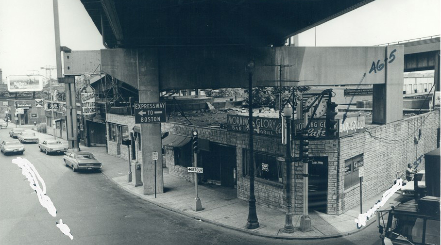
The folks at the Boston City Archives wonder if you can place this photo (yes, part of the photo is whited out so you don't just see the street name written on it). See it larger.
Neighborhoods:
Topics:
Ad:
Support Universal Hub
Help keep Universal Hub going. If you like what we're up to and want to help out, please consider a (completely non-deductible) contribution.
Comments
Neponset Circle?
One of only two places I can think of where the Southeast Expressway crosses over a commercial street.
The other is Dorchester Avenue just south of Andrew Square, but I don't think a sign there would say "To Boston".
Hints
It's not the Expressway.
That particular piece of road no longer exists
Photo in Question - NE corner of City Sq Charlestown
This was the corner to the diagonal right of the old Y in City Sq, Charlestown, along Chelsea Street. The overhead expressways are the on and off ramps to the then Mystic River Bridge, now the Tobin. In the 60's, as a kid, used to shine shoes along this bar route, hitting the Y first, then walking into these bars from The Moring Glory north to the Blue Mirror, outside of the Navy Yard's gate 1. My shoeshine gold mine used to be Scally's, catching it on time for the Daily Double horse race.
Earlier in the day I used to start at the old Horse Shoe Tavern on Bunker Hill Street work the bars up BH till Kelly's then over the hill to the "spud" and close my Saturday along this strip of bars. At .25c/shine I would make anywhere form $18-$24 on a Saturday, not bad for a 9 yo "project" kid ;)
city square
charelstown
winter hill gang hangout
looks like there weren't many places to grab a drink around there.
Corner of Chelsea St and Rutherford Ave
nfm
Charles River Avenue
I think Rutherford started on the other side. Charles River Avenue was the road that was parallel to the east side of the bridge.
You can just make out the furniture warehouse in the back where Lt. Stephen Minehan died in 1994. http://www.pictureboston.com/blog/2019/06/24/boston-firefighter-steven-m...
Site of a gang murder back in the day
https://en.wikipedia.org/wiki/Bernie_McLaughlin
Interesting
Charlestown
today's view...
https://goo.gl/maps/mbTZcQEu5h5w8jnZA
Cool
When I commute, that's part of my bike commute. Links the bike lanes up with the bridge.
Charlestown
That looks like City Square in Charlestown before the CANA Project that pre-dated the Cental Artery Project.
4 Places to Get Booze
There are what, 4 bars between Grove Hall and Mattapan now and here we get 3 bars and a packie in 600 feet?
The City has changed just a bit.
This is Chelsea Street in City Square.
Bars and Liquor Stores
Every single establishment in the picture is a bar or a liquor store. That makes me want to say South Boston, but it looks more like Charlestown.
Keep in mind…..
…that the Charlestown Navy Yard & Hood’s were nearby and supplied steady clientel for all that booze. My father worked at Hood’s a couple of summers in high school, called the Morning Glory “a bucket of blood” and told about workers mobbing it and the others at shift changes- both those ending their shift and those beginning. As he put it- “Things could go south fast on a daily basis because everyone was half in the bag by breakfast.” Lots of alcohol-fueled brawls, particularly among the Navy Yard crews, during his time there
The former
Dudley Square
Charlestown corner of Chelsea and Rutherford
Found this "So of course there's got to be a Charlestown connection to Whitey and the Winter Hill Gang. Here it is, in brief. In the 1960s, there was a war between the McLaughlin Gang of Charlestown and the Winter Hill Gang, after Georgie McLaughlin made a move on the girlfriend of Winter Hill Gang member Alex Rocco. McLaughlin was beaten. His brother Bernie paid a visit to James "Buddy" McLean, then-head of the Winter Hill Gang, wanting information on who did the deed. When McLean refused, the McLaughlins tried to wire a bomb to his wife's car. In retaliation, McLean shot and killed McLaughlin coming out of the Morning Glory bar in Charlestown. The Morning Glory is a legendary spot because of that battle. Today, Max and Dylan's Restaurant stands in roughly the same spot where the bar used to be, on Chelsea Street at the corner near City Square."
And Alex Rocco became an actor
Best known for playing Moe Greene in The Godfather
outta City Square=
McAvoy's under the old ramp up to the Tobin Bridge towards Terminal Street by the Projects at Decatur and Vine Streets
That's an interesting
That's an interesting integration of an elevated highway and a neighborhood business. Which was built first?
If we have to have an elevated road, this is much better than putting a parking lot or bare concrete area under it, like we do today: https://goo.gl/maps/GeoBGVfBdPqip89v5
Why don't we tuck buildings
Why don't we tuck buildings under highways anymore? We all bemoan the loss of grit and this is a way to provide it instantly, by allowing shiny new buildings to get a layer of grime not seen since the bad old days. All that currently vacant land could be generating tax dollars to boot! Perhaps all the business patrons can participate in an annual lottery to see who gets murdered, as a sacrifice to the Gods of Cred. Ben Affleck and Marky Mark can show up in a fake mustaches and quiz the audience on who they think did the deed, then an adolescent imitating Howie Carr can talk incessantly about The Lottery on AM radio all year until the next one.
Maybe constant noise and
Maybe constant noise and vibration will damage the buildings? It will make repairing highway and buildings more difficult?
Fire?
I think modern fire codes - if the restaurant burns down it can take out the highway as well. (and concrete falling off a highway could damage a building I suppose)
Its the south station cafe ,
Its the south station cafe , the lil one that stays open 24hrs a day.
The Answer!
Thanks for playing, folks! This photo shows the intersection of Chelsea and Chamber Sts at City Square in Charlestown on July 28, 1972.
Thank you Boston City
Thank you Boston City Archives. This one was fun and educational.