Hey, there! Log in / Register

What happened to Marker 123?
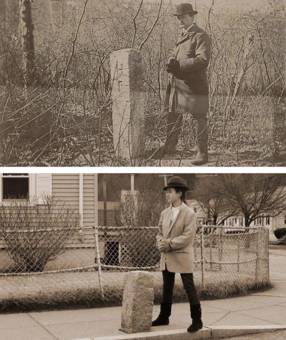
By adamg on Sun, 03/04/2012 - 5:42pm
While perusing the city's photos of boundary checking in 1896, I noticed several were of markers with "HP" on one side, from back when Hyde Park was still an independent town. Hmm, could they have a photo of the one a couple blocks away from us?
Sure enough, they did, but it seemed a lot taller than I remembered it. So today, the kidlet and I went down to Dale Street to check out Marker 123. And as you can see from the photos, it is, indeed a lot shorter than it used to be.
One assumes granite doesn't just shrink like that, so what's the deal? A possible clue is on the map showing the marker in 1896: It features a creek running on the other side of Dale (down to Stony Brook on the other side of the train tracks), a small tributary just near the marker and marshes on either side of the street.
So no doubt when Windham and Sherrin streets were built, they first dumped several feet of fill in the land around the marker. Now, a 1912 map of Hyde Park, after it became part of Boston, doesn't show those streets. So when they were built, Hyde Park was part of Boston and there was no longer any need for a boundary marker and yet, the marker was left in place, albeit a few feet lower than it used to be.
Top photo from the City of Boston Archives. Posted under this Creative Commons license.
Neighborhoods:
Ad:
Support Universal Hub
Help keep Universal Hub going. If you like what we're up to and want to help out, please consider a (completely non-deductible) contribution.
Comments
Readville
Across from the Readville train station on W. Milton Street where the welcome to HP/Readville sign is, there is a marker showing the distance to Boston and Providence...is one of these markers what you are talking about?
No. That was put in place
No. That was put in place just a few years ago when they reworked that intersection and added the flower bed where the 'marker' sits.
Haven't You Ever Heard of Sinkage?
When the street was improved the grade may have been brought up around the sign for purposes of leveling.
Awesome.
This is too cute.
Also, since I have nothing better to do with my Sunday evening, I'm making a Google Map with the locations of all the monuments, so peoples don't have to go cross-referencing streets. I'll post it when I'm finished.
I've been poking around
I've been poking around looking for the markers. Did you ever make your map?
Marker on River Street
Google maps says it's near 637 River Street. About a 10 minute walk from Mattapan Square.
https://img.skitch.com/20120305-csmmgixhe7pipayuwm...
Oh, wow, how have I missed that one?
I guess I'm always just so awestruck by the World's Best Food market right next to it to notice it (I mean, come on, it has the world's best food!).
Double Haar
Been there...unless you're looking for canned Caribbean espresso, "world's best" is a highly diluted slogan.
I. Love. This.
Awesome photo update. Love it.
Finished map!
Alrighty, I approximated the location of the stones. Let's see how many of them are actually still there.
MAP.
Marker 121
I came across what I presume was marker #121 when I was looking at properties back in July. It was in the rear yard of the last house on the left Hallron St.
Marker 17 somehow got moved out of position on your map
It belongs somewhere in Charlestown, but the map has it up in Malden.
Fixed!
Fixed it. Careful when you're moving things, folks!
You've started an addictive trend, Gaffin
On my run today, I passed by Monument 115. God only knows I've been by it before, but today I knew I was hitting the town line and BAM, there it was, in all its D/B glory.
Keep up the good work.
White Boston Street signs
What I've been looking for are the white-with-black-lettering signs that are still up around Boston - the ones left over from the late '60s-early '70s. The most prolific ones I've found are...
- Baker and Temple Street in West Roxbury
- Farragut Place in West Roxbury;
- Grove Street on the West Roxbury/Dedham line with Bussey St
- Anawan Avenue near the Bellvue train station (a little rusted, though)
- Brookline Avenue at the Boston/Brookline border
- St. Mary's Street near the C-line T stop
I think there were a few in Mattapan, but I don't know if they still exist.
The other interesting thing about the signs
Are the interesting brackets used to connect them to the posts.
There is one of those street
There is one of those street signs at the corner of Clifrondale St and Rosecliff in Roslindale. I hope they never replace it. Its looking a bit old but it still reads well.... it says Cliftondale St.
Couldn't find markers 9 through 15
Markers 9 through 15 delineate the Boston-Somerville border just west of Sullivan Square, so I went off looking for them this afternoon. Either I didn't recognize them, or they are too badly eroded for me to see what they are, or they're just gone.
Marker 12?
If you look on Google Maps street view, it appears to have been incorporated into a masonry wall. I didn't know this from street view, but because a friend lived on the Boston side of the line in that neighborhood.
UPDATE: Yep - it is there!
1. Go to http://maps.google.com/maps/place?ftid=0x89e370c49...
2. Pick "street view"
3. rotate the compass so that "N" is in the 3 o'clock position
The granite marker can be seen sticking out of the concrete retaining wall!
OK, I'll take another look tomorrow
There are a lot of broken stone fragments all over the areas surrounding these marker sites, which makes me wonder if I might be looking at fallen remnants of some of the markers.
Marker 12 - maybe, maybe not
I went there and looked for any obvious sign (such as etching) that this was an old boundary marker, but couldn't find any. If it is the old marker, it has been moved from its original position, as the entire width of Crescent Street (though not the east sidewalk) is in Somerville.