Hey, there! Log in / Register

A triple decker on wheels
By adamg on Thu, 06/26/2014 - 10:17am

The folks at the Boston City Archives wonder if you can place this photo.
Neighborhoods:
Topics:
Free tagging:
Ad:
Support Universal Hub
Help keep Universal Hub going. If you like what we're up to and want to help out, please consider a (completely non-deductible) contribution.
Comments
Something to do with the
Something to do with the southwest corridor/inner belt fiasco?
Nice front windows !
Nice front windows !
Old School
The owner was so hard core THEIR HOUSE DOUBLE PARKED AND NEEDED A SPACE SAVER!
my first thought was
my first thought was Frankfort street/Neptune road in in east boston, but judging by the hats/cars this photo was about 20 years before that
East Boston?
I was thinking East Boston/Airport Expansion, too. But, also question the timing due to the clothes.
Neptune road East Boston ,
Neptune road East Boston , House being moved by truck, by emminent domain , early stages of Logan Airport expansion, looks like the 1940's according to the humphry Bogart apparel & hats the men are wearing.
Wasn't Neptune Rd a Boulevard?
Could this be around the corner on Saratoga St.?
Now that's what I call a mobile home
n/t
On the inside, they did look like trailers
At least the ones that friends lived in in the 1980s, where they had been infected with wood paneling.
Is that a dirt road?
Is that information useful in guessing the location?
Dorchester Avenue At The Southeast Expressway?
From the clothes, I think the date was the early 1950's. No triple-deckers like these in the path of the Tobin Bridge or the Fitzgerald Expressway, but this looks very much like Dorchester Avenue, where the Southeast Expressway was being constructed at that time.
Google Maps Streetview
Pre-Vinylization
Look how great these streets were before vinyl enveloped every surface. The difference is just stunning to see.
Nice Palladian windows
A lot of that crappy-looking vinyl siding is installed to encapsulate the hideous and costly to remove asbestos siding installed in the 1940's and 1950's. If this house is still standing I'll bet they've covered over the asbestos by now.
That and lead paint.
That and lead paint. Abatement was too costly and risky for many families so they did the cheap and simple thing which was to install vinyl siding to contain it all.
No idea, but...
I suspect that the house is being moved to the lot on the right side of the photo, about where the steel beams are. The telephone lines in the foreground haven't been moved out of the way, as they would most likely have been if the house was proceeding any further.
Is this possibly Centre St
Is this possibly Centre St/Hyde Sq in Jamaica Plain? The wall in the background looks like it may belong to Angel Memorial
i don't think it's centre st
i don't think it's centre st in hyde sq.
Andrew Square?
Looks like Southampton Street looking into the square. Has to be early 50's.
Sachem Street , Mission hill
Sachem Street , Mission hill 1940's.....
The Answer!
Thanks for playing folks! This house is being moved from #408 Frankfort Street to #2 Milton Street in East Boston. The date is Sept 13, 1950
huh?
where is milton street in east boston?
i don't know if it...is this correct?
Now Horace Street
I got curious and did some research. It looks like these houses on Frankfort were moved to make way for access to the train tracks from Bennington Street to create Wood Island station. Apparently for some time Horace St. was called Milton St. (In 1912 it was Horace, in 1922 it was Milton, now it is Horace again). You can see this one and its transplanted neighbors lined up on Horace St. in East Boston.
Yes, I Think You're Right! - #4 Horace Street
I was just as curious and have been searching it out myself too. This HistoricAerials.com comparison shows what happened when the Blue Line and Wood Island Stations were built through that neighborhood. What is now called Horace Street didn't exist in 1938, but did in 1955.
The house at #2 Horace Street today, is definitely not the house being moved. However if Milton Street had odd and even numbers on the same side, then #2 Milton would be #4 Horace today:

Google Maps Streetview
If you stroll down the Streetview, all of the houses in that stretch appear have been moved there as well. Alas, none of their Palladian windows remain.
Same neighborhood, different house
Here's another photo: 426 Frankfort to 10 Milton St.
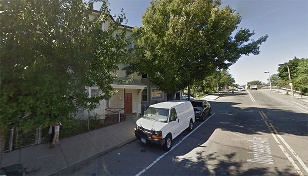
408 Frankfort today
One house all alone:
https://maps.google.com/maps?q=408+frankfort+street,+east+boston&ll=42.3...
It looks like this lonely building _could_ be the house you see at the left side of the moving house photo....
Not Today
That google image looks like it was taken in the fall. Massport bought that 3 decker in the past few months and razed it in April.
Looks like it was well-kept up...
... sort of sad.
Any idea why?
There's a housing shortage in this city. Why has Massport been buying residential properties and razing them? Unless there are concrete plans for that property, it seems like an awfully wasteful practice.
Really, Massport did not
Really, Massport did not swallow up that house, looks like a great setting for a Movie..or a TV sitcom..
Get off my lawn
Resident parking only sign and all
Triple decker being moved
I couldn't believe my eyes today when I stumbled across this photo. I grew up in this house. The house was originally located on Pope Street and was moved to 409 Frankfort street to make way for the route 1 highway. My father moved into this house when he was 16 years old after my grandfather bought it in 1932. He inherited this house and lived in it until he died at the age of 91 in 2007.
My parent used to talk about the evening when there was a knock on the door after they had just finished dinner. A surveyor from the MBTA told them that there house was in the path of the Blue Line expansion and would be taken by eminent domain and moved. They were forced to sell to the MBTA with the option of buying it back after the move to Horace Street. After World War ll, there was a housing shortage, so houses had to be moved instead of torn down. My older sister was a three month old infant at this time and I was to be born three years later at the Horace Street location. This house was moved twice.
The MBTA surveyor told my father that although he did not realize it at the time, that he was among the lucky ones who would escape this area. The above ground railroad split the street into two sections and the remaining houses had railroad tracks in their backyard. Some houses had a view of the train platform from their windows.
My parents always spoke fondly of their time on Frankfort Street as at one time this area that included the Neptune Road area was one the the most beloved and prestigious areas of the city.
As time passes fewer and fewer can remember the recreational area and the harbor. Frederick Law Olmsted designed Wood Island park with it beaches and boating and hatch shell like the one on the esplanade. There are currently no houses left in this neighborhood and the park is a runway and the harbor has been filled.
Thanks so much....
... for sharing your memories!