Hey, there! Log in / Register

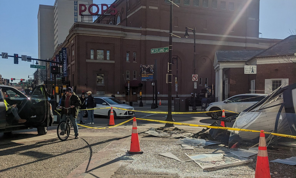
How fast do you have to be going to take out the tall map kiosk thing behind Symphony Hall?
By adamg on Sat, 12/16/2023 - 9:47pm

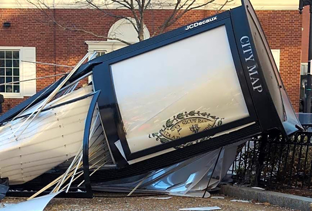
The remains of the kiosk on the right. See it larger.
Marcos surveyed the damage at Massachusetts and Westland avenues in the Fenway, after somebody slammed into the Boston map kiosk that had long stood there early this morning:
Safer streets and concrete protected bike lanes needed. This area especially has high foot and bike traffic. I walk and bike in this area every day. There is glass everywhere. Not good to have a giant pickup blocking the sidewalk also.
Somebody filed a 311 report at 9:53 a.m.:
Glass everywhere 50+ feet up mass ave , 9 ft kiosk toppled, laying on sidewalk and street.
Another person filed a similar report at 7:45 a.m.
Neighborhoods:
Topics:
Free tagging:
Ad:
Support Universal Hub
Help keep Universal Hub going. If you like what we're up to and want to help out, please consider a (completely non-deductible) contribution.
Comments
Dangerous spot
I'm surprised there aren't more accidents there. It can be an odd intersection to navigate, and dangerous with so many pedestrians, but there isn't a whole lot you can do about it, given the layout.
Bollards!
That is a pretty sketchy intersection.
Bring on the bollards!
Sure there is
Don't drive in Boston. Walk, bike, or find some other way to get there.
Ramming speed.
When you're a kiosk...(you know the rest)...
The officer investigating the crash will make an estimate
And the attorney for the driver will get an analysis saying they were going the speed limit. Then all charges will be dismissed.
Or is that just the case for failed politicians?
That thing was always in the
That thing was always in the way!
I bet the GPS is to blame.
I bet the GPS is to blame.
No snark tag?
GPS doesn't drive the car. The driver is to blame.
good!
The map kiosk was useless. The map orientation was completely confusing to anyone looking at it for directions. It should not be reinstalled until they figure out a way for the map to actually be useful to people who need help.
Looking for Falmouth Street
At Symphony Hall station on the outbound side, there is (or was) a sign directing people to Falmouth Street, a street that was eliminated thanks to the construction of the expansion of the Christian Science Plaza in the 1970s. I can imagine a resident or two looking for that street on the map.
More Massholery, 'tis the
More Massholery, 'tis the season.
Maybe they were late for
Maybe they were late for something?
How are they gonna blame this
How are they gonna blame this one on the road diet?
Alabi
Where exactly was Kendra Lara at that time?
Thankful nobody was injured
This is a high traffic area - with lots of pedestrians and bikes - I cross that street on a regular basis. This could have been a tragic incident.
A pedestrian struck last night in Back bay
On St. James and Clarendon. People are driving like crazies.
This driver did us all a favor
I hate those f*cking ad kiosks.
How long is "long standing"?
It wasn't there in the 2000's was it? I used to hang out with friends down there. When was it installed?
Looking at Google Street view
Looking at Google Street view it was put up in 2016, although before that it was a smaller billboard that had a map on one side at least some of the time.